Sold20241821 Woodbridge Map of Asia and Australia -- AsiaTitle: 1821 Woodbridge Map of Asia and Australia -- Asia Cartographer: W. Woodbridge Year / Place: 1821, Hartford Map Dimension (in.): 8.7 X 10.3 in. This is an excellent map of Asia with Australia inSee Sold Price
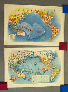
Sold20231831 Woodbridge Map of North America, Europe, Asia and on verso Map of Pacific Ocean -- PolarTitle: 1831 Woodbridge Map of North America, Europe, Asia and on verso Map of Pacific Ocean -- Polar Projection of North America and Asia [verso] Pacific Ocean with a View of Australia and Polynesia CSee Sold Price
Sold20221831 Woodbridge Map of North America, Europe, Asia andTitle: 1831 Woodbridge Map of North America, Europe, Asia and on verso Map of Pacific Ocean -- Polar Projection of North America and Asia [verso] Pacific Ocean with a View of Australia and Polynesia CSee Sold Price
Sold2018SDUK: Map of Asia & Australia on Gnomonic ProjectionTitle/Content of Map:'WORLD ON GNOMONIC PROJECTION, IV, Asia.' Cotidal lines are marked on the map. ASIA AUSTRALIA. On Gnomonic Projection. China Indian Ocean. Date Printed: 1846 Image Size: Approx 32See Sold Price
Sold20191845 Lizars Map of Asia and Australia -- AsiaReserve Reduced! Title/Content of Map: 1845 Lizars Map of Asia and Australia -- Asia Date: 1845 c., Edinburgh Cartographer: D Lizars Size: 10.8 X 9.2 in. This is very nice map of Asia and Australia wiSee Sold Price
Sold2020Cooke, George 1801 Antique Map of Asia & AustraliaShowing New Holland in bottom right. Copper Engraved Map Published 1801-07 by Macdonald & Son, London for "Modern and Authentic System of Universal Geography" By George A. Cooke. Folds as issued. PapeSee Sold Price
Sold2022Asia, Australia & New Zealand. Commercial. Import & export routes 1925 old mapTITLE/CONTENT OF MAP: 'Asia and Australia and New Zealand - Commercial Development' DATE PRINTED: 1925 IMAGE SIZE: Approx 50.0 x 37.5cm, 19.75 x 14.75 inches (Large); Please note that this is a foldinSee Sold Price
Sold2017Antique framed map of Indian Ocean, Asia, AustraliaTitle/Content of Map: Antique framed map of Indian Ocean, Asia, Australia Date Printed: 1713 Cartographer: Aa, Pieter van der Size (in): 11 x 8 Very attractive framed copper-engraved antique map by PiSee Sold Price
Sold20201750s Map of Asia and Australia -- A Map of Asia fromTitle/Content of Map: 1750s Map of Asia and Australia -- A Map of Asia from the Latest and Best Authorities Cartographer: Anonymous Year/Place: late1740s to late 1770s, London Size: 9.9 X 7.9 in. ThisSee Sold Price
Sold20211806 Cary Map of Asia and Australia -- A New Map ofTitle: 1806 Cary Map of Asia and Australia -- A New Map of Asia, from the Latest Authorities Cartographer: J Cary Year / Place: 1806, London Map Dimension (in.): 18.1 X 20.5 in. This is an excellent,See Sold Price
Sold2021Group of vintage mapsSemi contour North America, Asia and Australia, multiple maps on one roll, map of LaSalle countySee Sold Price
Sold2024Brockhaus (Pub) 1880's Lot of 21 Antique MapsIncl Balkans, World, Switzerland, Italy, Great Britain, France, Germany, Ethnographic Maps, Europe, Africa, Australia/Polynesia, Asia, South America, Hungary, Scandinavia and others. Lithograph Maps PSee Sold Price
Sold2020SDUK: South Asia, Australia and Oceania (2 sheets)The highly detailed gnomonic projection two-page map of South Asia (from the Arabian Peninsula to Indonesia), Australia, and Oceania engraved by J. & C. Walker and published by Charles Knight for theSee Sold Price
Sold2017Severin (Marc F 1906-1987) Imperial Airways EuropeSeverin (Marc F 1906-1987) Imperial Airways Europe Africa Asia Australia, poster brochure for all Classes of Air Liners, cutaway views, Map of Empire Routes, printed by Ben Johnson May 1934 - 75 x 50See Sold Price
Sold2021Covarrubias Pacific Asia Pictorial Maps (2)Maps of the Pacific, Golden Gate International Exposition. NY, 1942. Miguel Covarrubias (1904-1957). 2 Maps: Peoples and Economy. Australia, Hawaii, Asia, Americas. .See Sold Price
Sold2022Ratzel, Friedrich 1898 Lot of 5 Ethnographic MapsIncl Oceania/Australia, Africa, America, Asia/Europe. Lithograph Maps Published 1896-98, London for "The History of Mankind" by Professor Friedrich Ratzel. Translated by A. J. Butler. Reverse side blaSee Sold Price
Sold2016Asia and Australia by FinleyOriginal engraving by Young & Delleker, published by Anthony Finley, 1826. Nice original color, clean bright map sheet. Dimensions 10" x 14". No Reserve Buyer pays shipping - ships from Ocean View, DESee Sold Price
Sold2017Mitchell: Rare Antique Map of Asia, 1848Scarce 1848 Mitchell map of Asia. Vivid original hand coloring. Inset of Australia. Shows the entire breadth of Asia. Mitchell maps of the mid-to-late 1840s were some of the better maps produced in AmSee Sold Price
Sold2016Anthony Finley: Asia, 1829Map: Asia Maker: Anthony Finley Date: 1829 Size: Quarto, 13.8 inches high x 18.4 inches wide All of Asia including Japan and Australia. Please note that this lot has a reserve. When you leave a bid inSee Sold Price
Sold2019Maps 19th Century Mixed Lot of 15Incl Asia Minor, Asia, Europe, Denmark, Manchester, Australia, Canada, USA, North America, UK, Germany, World Rainfall & Vegetation, Syria, Europe, Asia, and Nubia/Abyssinia. Lot of 15 sheets of MapsSee Sold Price
Sold2021Tirion 1733 Map of AsiaDESCRIPTION: Map by Isaac Tirion, engraved by Jacob Keyser. Titled "Nieuwe Kaart van Asia na de alderlaatste Ontdekking int licht gebracht." Depicts Japan, Kamchatka Peninsula, Australia's northern coSee Sold Price
Sold2021Visscher 1698 Map of Asia & the East IndiesFeatures discoveries of Tasman, Janszoon, and Cartensz with Australia and New Guinea. Includes compass rose, dedicated coat of arms of D. Henrico Spiegel, and title cartouche surrounded by allegoricalSee Sold Price
Sold2017Asia (showing 'New Holland,' or Australia) MapAsia (showing 'New Holland,' or Australia), 17 x 13.75 in, c. 1850, Thomas Cowperthwait Please note that this lot has a confidential reserve. When you leave a bid in advance of the auction, submit youSee Sold Price
Sold20211847 Map of AsiaAuthor: Cowperthwait Title: 1847 Map of Asia Medium: Ink on Paper Dimensions: 17"X14" Map of Asia dated 1847. Engraved by Thomas Cowpertwait in Philadelphia. Lower left inset of Australia. Color codedSee Sold Price
7 days LeftTrillium Antique Prints & Rare BooksOxley - Map of the New South Wales, Australia (New Holland)US$100
7 days LeftTrillium Antique Prints & Rare BooksPrevost - Chart of the South Pacific Ocean with part of New Holland (Australia), New Zealand, andUS$75
7 days LeftTrillium Antique Prints & Rare BooksPrevost - Chart of the Pacific Ocean with part of the Americas, China, and New Holland (Australia)US$75
3 days LeftJasper5211x13mm Golden South Sea Pearls- Pink Edison - 18 kt. Yellow gold - NecklaceUS$500
7 days LeftTrillium Antique Prints & Rare BooksDe Jode, Rare, pub. 1593 - Map of Asia (Tertiae Partis Asiae)US$100
5 days LeftNY Elizabeth 1760 WORLD'S HISTORY ON OLD GERMAN VELLUM, ILLUSTRATED WITH A MAP OF CENTRAL ASIAUS$100
4 days LeftJasper52WORLD 1910. Colonial possessions. Africa Asia India West/East Indies 1917 mapUS$15
Freeman's | Hindman[MAPS-THE AMERICAS]. 11 maps, incl. [Herrera y Tordesillas]. Descripcion de las Yndias Ocidentales. US$250
7 days LeftTrillium Antique Prints & Rare BooksHarris - Map of India and East Indies Islands (Part of China & East Asia)US$75
3 days LeftJasper521696 SYRIA Asia Minor & Syrian-Arabic region HISTORY antique ILLUSTRATED vellumUS$340
5 days LeftForum AuctionsCartography.- Cary (John) A New Map of England...1821, hand-coloured engraved map, 1823 & others£50


![1831 Woodbridge Map of North America, Europe, Asia and on verso Map of Pacific Ocean -- Polar: Title: 1831 Woodbridge Map of North America, Europe, Asia and on verso Map of Pacific Ocean -- Polar Projection of North America and Asia [verso] Pacific Ocean with a View of Australia and Polynesia C](https://p1.liveauctioneers.com/5584/285598/150695018_1_x.jpg?height=310&quality=70&version=1681855790)
![1831 Woodbridge Map of North America, Europe, Asia and: Title: 1831 Woodbridge Map of North America, Europe, Asia and on verso Map of Pacific Ocean -- Polar Projection of North America and Asia [verso] Pacific Ocean with a View of Australia and Polynesia C](https://p1.liveauctioneers.com/5584/231769/120064716_1_x.jpg?height=310&quality=70&version=1641336545)


![[MAPS-THE AMERICAS]. 11 maps, incl. [Herrera y Tordesillas]. Descripcion de las Yndias Ocidentales. (1 of 0)](https://p1.liveauctioneers.com/dist/images/placeholder.jpg?height=282&quality=70)


