Sold20211827 Thomson Map of Asia -- AsiaTitle: 1827 Thomson Map of Asia -- Asia Cartographer: J Thomson Year / Place: 1827, London Map Dimension (in.): 20.2 X 23.6 in. This is an excellent, large, double page map of Asia. The Great Wall ofSee Sold Price
Sold2023Thomson, John (Pub) 1825 Map. AsiaCopper Engraved Map Published 1825 by John Thomson, Edinburgh for "The Edinburgh School Atlas" by N. R. Hewitt. Maps Engraved by Hewitt. Original Outline Hand Colour. Rare. Paper Size: 10.5 x 8 inch (See Sold Price
Sold2017Thomson: Map of Russian Empire in Asia & Europe, 1817Title/Content of Map: 'Russian Empire' Russia in Asia & Europe. Siberia Date Printed: 1817 Image Size: Approx 52.0 x 63.5cm, 20.5 x 25 inches (Large); Please note that this is a folding map. Type: AntSee Sold Price
Sold2023Thomson, John (Pub) 1825 Map. Turkey in AsiaCopper Engraved Map Published 1825 by John Thomson, Edinburgh for "The Edinburgh School Atlas" by N. R. Hewitt. Maps Engraved by Hewitt. Original Outline Hand Colour. Rare. Paper Size: 10.5 x 8 inch (See Sold Price
Sold2021Thomson, John (Pub) 1825 Map. Turkey in AsiaCopper Engraved Map Published 1825 by John Thomson, Edinburgh for "The Edinburgh School Atlas" by N. R. Hewitt. Maps Engraved by Hewitt. Engraved Vignette in corner. Original Outline Hand Colour. RareSee Sold Price
Sold2023Chart of the northern passage between Asia & America. Pacific. THOMSON 1830 mapTITLE/CONTENT OF MAP: 'Chart of the northern passage between Asia and America' DATE PRINTED: 1830 IMAGE SIZE: Approx 53.0 x 65.0cm, 21 x 25.5 inches (Large); Please note that this is a folding map. TYSee Sold Price
Sold2021Thomson, John (Pub) 1825 Hand Col Map of AsiaCopper Engraved Map Published 1825 by John Thomson, Edinburgh for "The Edinburgh School Atlas" by N. R. Hewitt. Maps Engraved by Hewitt. Engraved Vignette in corner. Original Outline Hand Colour. RareSee Sold Price
Sold2023Chart of the Northern Passage between Asia & America. THOMSON 1817 old mapTITLE/CONTENT OF MAP: 'Chart of the Northern Passage between Asia & America' DATE PRINTED: Published in 1817. Engraved on 20th September 1816; this date is marked on the map IMAGE SIZE: Approx 52.0 xSee Sold Price
Sold20202 Maps of Asia2 Maps of Asia- 1). John Cary- ''A New Map of China, From the Latest Authorities''- engraved map, 1801, some minor staining in margins. 18 1/2 x 20 1/2'' 2). John Thomson- ''Corea and Japan''- engraveSee Sold Price
Sold2017Thomson: Antique Map of Alaska/Bering Strait, 1816Map: Chart of the Northern Passage between Asia & America Cartographer: Thomson Place & Date: Edinburgh / 1816/1817 Size: 23 1/4" x 19 1/2" Condition: overall age toning; browning and creases along ceSee Sold Price
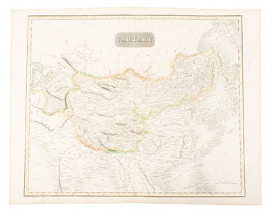
Sold2019Map of Tartary comprising most of AsiaHeading: (Maps) Author: Thomson, John Title: Tartary Place Published: Edinburgh Publisher: Date Published: 1814 Description: Engraved map, hand-colored in outline. 49.8x59.5See Sold Price
Sold2023Corea and Japan by John Thomson. East Asia. Korea 1817 old antique map chartTitle: "Corea and Japan" by John Thomson. East Asia. Korea 1817 old antique map chart Description: Corea and Japan' by Drawn & engraved by John & George Menzies for John Thomson's "New General Atlas"See Sold Price
Sold2022Corea and Japan by John Thomson. East Asia. Korea 1817 old antique map chartTITLE/CONTENT OF MAP: 'Corea and Japan' DATE PRINTED: Published in 1817. Engraved on 16th August 1815; this date is marked on the map IMAGE SIZE: Approx 52.5 x 67.0cm, 20.75 x 26.5 inches (Large); PleSee Sold Price
Sold2022Corea and Japan by John Thomson. East Asia. Korea 1830 old antique map chartTITLE/CONTENT OF MAP: 'Corea and Japan' DATE PRINTED: 1830 IMAGE SIZE: Approx 52.0 x 66.5cm, 20.5 x 26.25 inches (Large); Please note that this is a folding map. TYPE: Antique early 19th century atlasSee Sold Price
Sold2018Damaged Maps 18th-19th Mixed Lot of 11 MapsMixed Lot of 11 - All with faults. Incl Asia, Europe, France, Hastings, London, UK, Palestine, Glasgow, and France. Examples Gall & Inglis, Ordnance Survey, Charles Copley, Guthrie, Thomson and othersSee Sold Price
Sold2023Beeton, Samuel 1868 Pair of Maps. Asia & Asia MinorLithograph Maps Published 1868, London for "Beeton’s Dictionary Of Geography" by Samuel Orchart Beeton. Folds as issued. Paper Size: 10 x 8 inch (26 x 20cm) Good ConditionSee Sold Price
Sold2024Nicolas Sanson - Map of Asia / Asia divided into its Principal RegionsCopper engraving, 1600s/1700s, "Asia divided into its Principal Regions." By Mr. Sanson, Geographer Ordinary to the King. Size: 58 cm x 88 cm.See Sold Price
Sold20241630 Mercator Map of Asia -- AsiaTitle: 1630 Mercator Map of Asia -- Asia Cartographer: G Mercator Year / Place: 1630, Amsterdam Map Dimension (in.): 7.3 X 10 in. This is an excellent smaller map of Asia. This map still show many mytSee Sold Price
Sold20181787 Sayer Map of Asia -- Asia and Its IslandsTitle/Content of Map: 1787 Sayer Map of Asia -- Asia and Its Islands According to D'Anville; Divided Into Empires, Kingdoms, States, Regions &ca... Date Printed: 1787, London Cartographer: R Sayer SizSee Sold Price
Sold20221744 Homann Map of Asia -- Asia Secundum Legitimas Projectionis Stereographicae Regulas et JuxtaTitle: 1744 Homann Map of Asia -- Asia Secundum Legitimas Projectionis Stereographicae Regulas et Juxta Recentissimas Observationes... / Carte de l'Asie Projettee Stereographiquement Tiree des RelatioSee Sold Price
Sold20241842 Arrowsmith Map of Asia -- AsiaTitle: 1842 Arrowsmith Map of Asia -- Asia Cartographer: J Arrowsmith Year / Place: 1842, London Map Dimension (in.): 18.7 X 23.8 in. This is an attractive, highly detailed double-page map of Asia. EuSee Sold Price
Sold20201858 Blackie Map of Asia -- AsiaTitle/Content of Map: 1858 Blackie Map of Asia -- Asia Date: 1858, London Cartographer: W Blackie Size: 14.2 X 19.2 in. This is a large attractive map of the continent. Plenty of detail is offered asSee Sold Price
Sold20211855 Colton Map of Asia -- AsiaTitle: 1855 Colton Map of Asia -- Asia Cartographer: J Colton Year / Place: 1855, New York Map Dimension (in.): 12.3 X 14.5 in. A very nice continental map of Asia. Plenty of topographical, river, lakSee Sold Price
Sold20181834 Malte-Brun Map of Asia -- AsiaTitle/Content of Map: 1834 Malte-Brun Map of Asia -- Asia Date Printed: 1834, Boston Cartographer: M. Malte-Brun / S. Walker Size: 9.3 x 7.5 in. An attractive and highly detailed map with topographicaSee Sold Price
3 days LeftAlbion AuctionsMarmocchi, F. C. 1845 Hand Col Map. Asia Minor. Macedonia Greece CyprusUS$5
3 days LeftAlbion AuctionsPrichard & Walker 1844 Hand Colored Map. Ethnological Map of AsiaUS$15(2 bids)
Featured16 hrs LeftJasper52Mitchell’s Map of Asia showing travel routes London, India, China & Japan, 1860US$45
2 days LeftOriental Art AuctionsAL-IDRISI AND ROGER II, A MAP OF ASIA IN NUZHAT AL-MUSHTAQ, 17TH CENTURY€4,000
Featured16 hrs LeftJasper52Turkey in Asia, Persia & Arabia by Alvin Jewett Johnson, 1862.US$75(1 bid)