20201836 Map of AmsterdamAuthor: Walker Title: 1836 Map of Amsterdam Medium: Ink on Paper Dimensions: 16"X14" Map of the city of Amsterdam dated 1836. Drawn by W.B. Clarke and engraved by H.R. Davies. Published by Baldwin andSee Sold Price
Sold20201838 Map of AmsterdamAuthor: Walker Title: 1838 Map of Amsterdam Medium: Ink on Paper Dimensions: 16"X14" Map of the city of Amsterdam dated 1836. Drawn by W.B. Clarke and engraved by H.R. Davies. Published by Baldwin andSee Sold Price
Sold20221836 Map of 25 Miles Round The City Of New-York.Historic Maps 1836 "Map of the Country Twenty Five Miles Round The City Of New-York." Published by D.S. Stone November 11, 1836-Dated, Hand-Colored Map titled, "Map of the Country Twenty Five Miles RoSee Sold Price
Sold20231836 map of North America1836 map of North America, engraved by Illman & Pilbrow in 1836 for Southern District of New York, in old frame, overall 18"T x 15"WSee Sold Price
Sold20211836 Map of Dublin, IrelandDESCRIPTION: Drawn by W. B. Clarke, engraved by E. Turrell, and published by Baldwin & Cradock. Conservation framed. MEASUREMENTS: Map 11" high x 15" wide; overall with frame 20-1/2" high x 23-1/2" wiSee Sold Price
Sold2018Antique French Copper Engraved Colored Map, Amsterdam18th century antique French copper engraved and hand colored maps of Amsterdam, Netherlands titled "Lemouicum, Auctore Jo. Faiano M.L. - Lymosin [on sheet with] Topographia Limaniae, Auctore GabrieleSee Sold Price
Sold20201836 Map of Durham Railway IllustratedA English county map of Durham circa 1860 with illustrations in the corners. Also marking railway stations. By tHomas Moule. Fine, light loss t lower left corner. Fine. Measures 10.5 x 8.5". Reserve:See Sold Price
Sold20221836 Map of Rahway, NJ by Tho & Hughes 23"x21"1836 Map of Rahway, NJ by Tho & Hughes 23"x21"See Sold Price
Sold2022Linschoten, Delineatio orarum maritimarum 1596LINSCHOTEN, Jan Van (1563-1611). Delineatio orarum maritimarum, terrae vulgo indigetatae terra do Natal. Engraved map. Amsterdam, 1596. 15 5/8" x 22 1/4" sheet. Comparable: Swann Galleries, 2013 - $2,See Sold Price
Sold2016CARTE PARTICULIERE DE VIRGINIE, MARYLAND, PENNSYLVANIA;CARTE PARTICULIERE DE VIRGINIE, MARYLAND, PENNSYLVANIA; ALEXIS-HUBERT JAILLOT (1632-1712), ENGRAVED HAND COLORED MAP, AMSTERDAM AND PAIRIS, PIERRE MORTIER, C.1693-1710 (AN IMPORTANT CHART OF THE MID-ASee Sold Price
Sold2017William Faden 1796 Map Eastern US, North AmericaFaden, William (BRITISH, 1749-1836); Map of the Eastern United States, North American with British Territories and Those of Spain according to the Treaty of 1784 (from a larger atlas), 1796; handcolorSee Sold Price
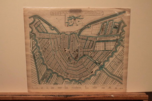
2019AMSTERDAM antique town city map plan. Inset AmsterdamTITLE/CONTENT OF MAP: 'AMSTERDAM.; inset environs of Amsterdam' DATE PRINTED: This map was originally published by Baldwin & Cradock in 1835; this date is printed on the map. This edition of the map wSee Sold Price
Sold2017SDUK: Antique City Map Plan of Amsterdam, 1847Title/Content of Map: 'AMSTERDAM.; inset environs of Amsterdam' Date Printed: 1847 Image Size: Approx 34.5 x 40.5cm, 13.5 x 15.75 inches (Large) Type: Antique steel engraved map with original outlineSee Sold Price
Sold20191937 Suchy Map of Historical Cleveland as it was inTitle: 1937 Suchy Map of Historical Cleveland as it was in 1836 -- Map of Cleveland and Ohio City… Date: 1937, Rochester Cartographer: A Suchy Size: 15 x 18.7 in. Additional Information: This is a vSee Sold Price
Sold2019Guillaume de Lisle (French, 1675-1726) - Orbis RomaniGuillaume de Lisle (France, 1675-1726) - Orbis Romani descriptio seu divisio per themata sub Imperatoribus Constantinopolitanis post Heraclii tempora facta Map, Amsterdam, 1742. Published by Covens anSee Sold Price
Sold2019Amsterdam, 1844Title/Content of Map: Amsterdam, 1844 Date Printed: 1844 Cartographer:Davies Material/Medium: Steel engraving Size: 13.5" x 16" City map of Amsterdam features drawings of the facades of important builSee Sold Price
Sold2019Group of Three WWII U.S. Pilot Escape Silk Maps, "Group of Three WWII U.S. Pilot Escape Silk Maps, " Amsterdam, Hamburg, Berlin, Warsaw on reverse Vilnyus, and Minsk," H. - 24 in., W. - 30 in.; " Stalingrad on reverse Stepnoy," H. - 22 in., W. - 20 iSee Sold Price
Sold202216TH C. MAP OF AMSTERDAM BY BRAUN & HOGENBERG"Amstelredamum, Nobile Inferioris Germaniae Oppidum (..)" by Frans Hogenberg (1535-1590) / Georg Braun (1541-1622). Handcolored copperplate engraving, perspective map with buildings, from the first paSee Sold Price
Sold20171836 Sduk Map Of LondonMap: SDUK, C.1836, London, 15.5 x 25.5 in. Please note that this lot has a confidential reserve. When you leave a bid in advance of the auction, submit your maximum. Jasper52 will bid on your behalf aSee Sold Price
Sold20181836 Tanner Map of IowaTitle/Content of Map: 1836 Tanner Map of Iowa -- Iowa Date Printed: 1836, Philadelphia Cartographer: H S Tanner Size: 15 x 12.8 This great map of Iowa Territory depicts just a handful of color-coded cSee Sold Price
Sold20171836 Tanner Map of West IndiesTitle: 1836 Tanner Map of West Indies -- West Indies Cartographer: H S Tanner Origin/Date: 1836, Philadelphia Size: 11 inches x 14 inches This highly informative map of the West Indies provides considSee Sold Price
Sold2016Dutch Hand colored Map of AmsterdamCirca 1650 titled: "Amsterdam aan de waterkant van t'Y te sien" previously framed, ghosting around image. center scratch, good margins. overall measurement: 23" x 12"See Sold Price
Sold2017Village of Auburn Map, 1836Map of village of Auburn. Published by Hagaman & Markham.1836. Ilustrated with The Auburn Prison; 18in. X 28in.See Sold Price
Sold2016Framed Map Of Amsterdam Joannem de RamAmstelodami Veteris et Novissimi Delineatio per Joannem de Ram - de Ram J. Frame: 34.25" x 31" image: 20.5" x 18"See Sold Price
Featured6 days LeftJasper521866 Johnson Map of Holland and Belgium - Johnson's Holland and BelgiumUS$40
6 days LeftJasper521772 GREEK BIBLE NEW TESTAMENT antique BIBLIA LATIN text MAP NOVUM TESTAMENTUMUS$360
May 24Marques Dos Santos, LdaF.DE WIT - 'Regni Poloniae et Ducatus Lithuaniae Voliniae, Podoliae...'€300
2 days LeftTrillium Antique Prints & Rare BooksAudubon, Amsterdam Edition - Marsh Hawk. 356US$100(1 bid)
May 30NY Elizabeth D. BLONDEL GENEALOGIAE FRANCICAE VELLUM ANCIENT FOLIO MAPS 1654 HISTORY OF FRANCEUS$50
2 days LeftTrillium Antique Prints & Rare BooksAudubon, Amsterdam Edition - Large-billed Puffin. 293US$100
2 days LeftTrillium Antique Prints & Rare BooksAudubon, Amsterdam Edition - Common Merganser. 331US$100


![Antique French Copper Engraved Colored Map, Amsterdam: 18th century antique French copper engraved and hand colored maps of Amsterdam, Netherlands titled "Lemouicum, Auctore Jo. Faiano M.L. - Lymosin [on sheet with] Topographia Limaniae, Auctore Gabriele](https://p1.liveauctioneers.com/6377/128239/65869733_1_x.jpg?height=310&quality=70&version=1540604375)


