Sold20201838 Map of AmsterdamAuthor: Walker Title: 1838 Map of Amsterdam Medium: Ink on Paper Dimensions: 16"X14" Map of the city of Amsterdam dated 1836. Drawn by W.B. Clarke and engraved by H.R. Davies. Published by Baldwin andSee Sold Price
Sold20191838 Map of Italy and SicilyCarte de L'Italie Ancienne and de L'Illyrie et de La Sicilie par Delamanche 1838See Sold Price
Sold2020Hall, Sidney 1852 Lot of 4 Maps - ContinentsIncl Asia, Africa, Europe and South America. Steel Engraved Map Published 1852, London for "A Grammar of General Geography" by the Rev. Goldsmith. Engraved by Sidney Hall. Folds as issued. Paper Size:See Sold Price
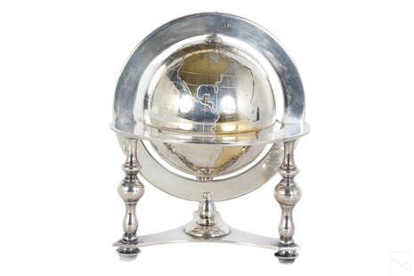
Sold2023Bulgari Sterling Silver & Vermeil Table Globe 805gA Bulgari Italian sterling silver table globe sculpture. Classical style design with spinning world map globe set within a round tri legged ring stand. Map continents finished in gold vermeil, and surSee Sold Price
Sold2023Collection of MapsCollection of maps including; 1.) Travel Map of Massachusetts, Connecticut and Rhode Island published by B. Brown & Parsons, Hartford, Connecticut, 1838. Map measures 14.5" x 20". Map exhibits some spSee Sold Price
Sold2021Glass World Globe PaperweightClear glass globe with textured and shaded world map continents. Measures 3 x 3.25 in. Desktop items, Paper & table accessories, home accents and decor, Art glass paperweight, globe paperweight, worldSee Sold Price
Sold2017Mallet: Antique Map of Antarctica, 1683Title/Content of Map: 'Continent Meridional Austral ou Antarctique' ANTARCTIC: Australia/New Holland incomplete. Unknown lands. Date Printed: 1683 Image Size: Approx Overall page size 13 x 21cm approxSee Sold Price
Sold20201838 Tanner Map of Louisiana -- A New Map of LouisianaTitle: 1838 Tanner Map of Louisiana -- A New Map of Louisiana with Its Canals, Roads & Distances from Place to Place, Along the Stage & Steam Boat Routes Date: 1839, Philadelphia Cartographer: H TanneSee Sold Price
Sold2023Scarce 1838 Smiley map of Middle StatesThomas T. Smiley atlas maps are extremely scarce, as they were produced only for a few short years in the 1830s and 1840s. Examples are extremely difficult to find. This one of the Middle States showsSee Sold Price
Sold20211838 Bradford Map of Indiana -- IndianaTitle: 1838 Bradford Map of Indiana -- Indiana Cartographer: T Bradford Year / Place: 1838 Boston Map Dimension (in.): 14.2 x 11 in. This is a nice and highly detailed state map. The counties are coloSee Sold Price
Sold20191838 Arrowsmith Map of Coastal China from the GreatTitle/Content of Map: 1838 Arrowsmith Map of Coastal China from the Great Wall to Macau -- The Maritime provinces of China with the Track of a Voyage from Canton to Shan-tung and Back Performed by W.HSee Sold Price
Sold20181838 SDUK Map of Southern Ireland -- IrelandTitle/Content of Map: 1838 SDUK Map of Southern Ireland -- Ireland Date: 1838, London Cartographer: SDUK Size: 12.3 X 18.3 in. This map is the southern portion of Ireland, Dublin and south. This is aSee Sold Price
Sold20211838 Italy MapAuthor: Delamarche Title: 1838 Italy Map Medium: Ink on Paper Dimensions: 13"X19" Description: Italy map dated 1838. Engraved by Delamarche. Part of Atlas de la Geographie. Published in Paris. CopperSee Sold Price
Sold2022Times Atlas 1895 Lot of 4 Continents MapsIncl Europe, Asia, North America and South America. Lithograph Map Published 1895, London for "The Times Atlas" Centre fold as published. Paper Size: 21.5 x 16 inch (54 x 41cm) Good ConditionSee Sold Price
Sold20165 maps (1838): VA, MD, DE, Balt., 4 cities.[United States/Virginia/MD/DE/DC] 5 Maps. Maps 6 and Maps 23-26 from T. G. Bradford, “An Illustrated Atlas, Geographical, Statistical, And Historical, Of The United States, And Adjacent Countries,��See Sold Price
Sold2016(4) 1838 BRADFORD Maps: NC, SC, GA, FL.[United States/South] 4 Maps. ++ NORTH CAROLINA. ++ SOUTH CAROLINA. ++ GEORGIA. ++ FLORIDA. ++ +Maps 28, 30, 31, 32 from T. G. Bradford, “An Illustrated Atlas, Geographical, Statistical, And HistoriSee Sold Price
Sold2016(4) 1838 BRADFORD Maps: OH, IN, MI, TN[United States/Near West] 4 Maps. ++ OHIO. ++ INDIANA. ++ MICHIGAN. [With inset of upper peninsula.] ++ TENNESSEE. ++ Maps 19, 20, 22, 29 from T. G. Bradford, “An Illustrated Atlas, Geographical, StSee Sold Price
Sold2021Tallis, John (Pub) 1852 Map. Asia ContinentSteel Engraved Map with Original Outline Hand Color Published 1852-56 by John Tallis, London for "The Universal Pronouncing Dictionary" by Thomas Wright. Drawn & Engraved by John Rapkin. Centre fold aSee Sold Price
Sold2022Barclay, James C1800 Hand Col Map. Asia ContinentHand Colored Copper Engraved Map Published C1800 Halifax & Newcastle, England for "Barclay's Universal English Dictionary…" by James Barclay. Maps Engraved by Clerk, Milton and others. Paper Size: 1See Sold Price
Sold2021Tallis, John (Pub) 1852 Map. Africa ContinentSteel Engraved Map with Original Outline Hand Color Published 1852-56 by John Tallis, London for "The Universal Pronouncing Dictionary" by Thomas Wright. Drawn & Engraved by John Rapkin. Centre fold aSee Sold Price
Sold2021Guthrie, William 1798 Map. Asia ContinentCopper Engraved Map Published 1798, London for "A New Geographical, Historical and Commercial Grammar..." by William Guthrie. The maps are by John Senex, Thomas Kitchin and others. Folds as issued. PaSee Sold Price
Sold2021Bartholomew, John 1889 Lot of 5 Continents MapsCommercial Continent Maps of Asia, Africa, Europe, North & South America. Lithograph Maps Published 1889, Cambridge for "Atlas of Commercial Geography" by John George Bartholomew. Paper Size: 12 x 10See Sold Price
Jun 12Dan Morphy AuctionsPHELPS’S TRAVELERS GUIDE THROUGH THE UNITED STATES; CONTAINING UPWARDS OF SEVEN HUNDREDUS$1,000
7 days LeftJasper52SIBERIA AND CHINESE TARTARY. Manchuria Mongolia Korea China. SDUK 1848 old mapUS$20
7 days LeftJasper52SIBERIA & CHINESE TARTARY Manchuria Mongolia Korea China East Asia SDUK 1844 mapUS$20
7 days LeftJasper52SIBERIA AND CHINESE TARTARY. Manchuria Mongolia Korea China. SDUK 1844 old mapUS$20
7 days LeftJasper52CENTRAL ASIA.Western Siberia, Khiva Bukhara. Independent Tartary SDUK 1844 mapUS$20
7 days LeftJasper52CENTRAL ASIA.Western Siberia, Khiva Bukhara. Independent Tartary.SDUK 1844 mapUS$20
7 days LeftJasper52CENTRAL ASIA.Western Siberia, Khiva Bukhara. Independent Tartary.SDUK 1844 mapUS$20
7 days LeftJasper52SIBERIA AND CHINESE TARTARY. Manchuria Mongolia Korea China. SDUK 1844 old mapUS$20
7 days LeftJasper52BUKHARA KABUL & BALUCHISTAN.Afghanistan Khorassan Sinde Pakistan.SDUK 1844 mapUS$40
6 days LeftThomaston Place Auction GalleriesFRAMED HANDCOLORED MAP OF AUSTRALIA BY JOHNSON & WARD, 1863US$150
Featured6 days LeftJasper521740. Map of Isle de Juan Fernandes ''Robinson Crusoe Island'', Chile. George AnsonUS$130
5 hrs LeftOriental Art AuctionsA RARE NON COLORED PRINTED FRENCH MAP OF THE ARABIC WORLD DURING THE OTTOMAN EMPIRE (ARABIA€1,000
12 hrs LeftPotter & Potter AuctionsGEESINK, Joop (1913 – 1984). Europa. 1957. Netherlands: KLM...US$100
1818 AuctioneersMusic. Rodwell, Anne - The Juvenile Pianist, or a Mirror of Music for Infant Minds. London:£14
3 days LeftTrillium Antique Prints & Rare BooksDavid Roberts - The Hypaethral Temple at Philae, Called the Bed of PharaohUS$200


![5 maps (1838): VA, MD, DE, Balt., 4 cities.: [United States/Virginia/MD/DE/DC] 5 Maps. Maps 6 and Maps 23-26 from T. G. Bradford, “An Illustrated Atlas, Geographical, Statistical, And Historical, Of The United States, And Adjacent Countries,��](https://p1.liveauctioneers.com/179/85723/44107992_1_x.jpg?height=310&quality=70&version=1456876561)
![(4) 1838 BRADFORD Maps: NC, SC, GA, FL.: [United States/South] 4 Maps. ++ NORTH CAROLINA. ++ SOUTH CAROLINA. ++ GEORGIA. ++ FLORIDA. ++ +Maps 28, 30, 31, 32 from T. G. Bradford, “An Illustrated Atlas, Geographical, Statistical, And Histori](https://p1.liveauctioneers.com/179/85723/44107998_1_x.jpg?height=310&quality=70&version=1457209205)
![(4) 1838 BRADFORD Maps: OH, IN, MI, TN: [United States/Near West] 4 Maps. ++ OHIO. ++ INDIANA. ++ MICHIGAN. [With inset of upper peninsula.] ++ TENNESSEE. ++ Maps 19, 20, 22, 29 from T. G. Bradford, “An Illustrated Atlas, Geographical, St](https://p1.liveauctioneers.com/179/85723/44107994_1_x.jpg?height=310&quality=70&version=1457208874)


![[MAP]. ORTELIUS, Abraham. Aevi Veteris, Typus Geographicus. 1601. (1 of 3)](https://p1.liveauctioneers.com/197/329395/177650532_1_x.jpg?height=282&quality=70&version=1715364962)
![[MAP]. ORTELIUS, Abraham. Romani Imperii Imago. 1592. (1 of 2)](https://p1.liveauctioneers.com/197/329395/177650537_1_x.jpg?height=282&quality=70&version=1715364962)


![[MAP]. ORTELIUS, Abraham. Africae Tabula Nova. 1592. (1 of 2)](https://p1.liveauctioneers.com/197/329395/177650533_1_x.jpg?height=282&quality=70&version=1715364962)


