Sold2015Morse's North American AtlasNew York: Harper and Brothers, 1842 (actually 1845), Sabin 50969, with 36 hand-colored maps (complete), bound in leather-backed marbled flexible boards, 17-1/4 x 13-3/4 in., maps have small amounts ofSee Sold Price
Sold2024Tanner's North America independent TexasHeading: (North America) Author: Tanner, Henry Schenck Title: North America Place Published: Philadelphia Publisher: Date Published: 1836-[1845] Description: Engraved map, hand-coloSee Sold Price
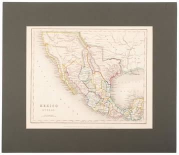
Sold2020Mexico with a large independent Texas, c.1845 mapHeading: Author: Gilbert, James Title: Mexico & Texas Place Published: London Publisher:Grattan & Gilbert Date Published: c.1845 Description: Engraved map, hand-colored in outliSee Sold Price
Sold2020North America with independent TexasHeading: Author: Dufour, Adolphe Hippolyte Title: [Amerique du Nord] Place Published: [Paris] Publisher:Imp. de N. Rémond Date Published: c.1845 Description: Engraved map, hand-See Sold Price
Sold2020Tanner's North America independent TexasHeading: (Texas) Author: Tanner, Henry Schenck Title: North America Place Published: Philadelphia Publisher: Date Published: 1836-[1845] Description: Engraved map, hand-coloSee Sold Price
Sold2023Historical Collections of New York, 1845New York State. - John W. BARBER & Henry HOWE. Historical Collections of the State of New York. New York: 1845. Octavo. 1 folding map (hand-colored I outline), plates, numerous illustrations. (ToningSee Sold Price
Sold2018Levasseur's decorative North AmericaHeading: Author: Levasseur, Victor Title: Amérique Septentrionale Place Published: Paris Publisher:A. Combette Date Published: [c.1845] Description: Steel-engraved map, hanSee Sold Price
Sold2022Early Nineteenth Century Map of Texas.Early 19th century hand colored map of Texas published by C.S. Williams, NE Corner of Market and 7th St., Philadelphia, 1845. Map engraved by J.H. Young exhibits previous folds and has been laid down.See Sold Price
Sold2018Meyer: South Carolina with Charleston InsetReserve Reduced! The beautifully detailed and colored map of South Carolina "with its canals, streets, steamship routes and distances between main towns" from the 1845 edition of Meyer's Hand-Atlas. ISee Sold Price
Sold2020Map of Mexico and Texas c.1845Heading: (Texas) Author: Wyld, James Title: Republic of Mexico and Texas Place Published: London Publisher: Date Published: c.1845 Description: Engraved map, with Mexico portionSee Sold Price
Sold2017History of Wyoming - William Miner 1845History of Wyoming in a Series of Letters from Charles Miner, to His Son William Penn Miner, Esq. Map of Wyoming present. Hand colored. Author: Charles MinSee Sold Price
Sold2024Marmocchi, F. C. 1845 Hand Col Map. Mediterranean"Carta dell' Italia dell' Africa della Numidia?." Folio Hand Colored Etching/Engraving Published 1845, Florence for "Atlante di Geografia-Storica Universale" by Francesco C. Marmocchi. Centre fold asSee Sold Price
Sold2024Marmocchi, F. C. 1845 Hand Col Map. Ancient Italy"L'Italia Antica" Folio Hand Colored Etching/Engraving Published 1845, Florence for "Atlante di Geografia-Storica Universale" by Francesco C. Marmocchi. Folds as issued. Paper Size: 27.5 x 21 inch (71See Sold Price
Sold2024Marmocchi, F. C. 1845 Hand Col Map. Arabia, Syria, Cyprus, Crete, Egypt"Siria Cipro, Creta Egitto Cirenaica Marmarica ed Arabia Carta di Geografica Antica" Folio Hand Colored Etching/Engraving Published 1845, Florence for "Atlante di Geografia-Storica Universale" by FranSee Sold Price
Sold2024Marmocchi, F. C. 1845 Hand Col Map. Egypt Pharaoh Empire, David SalomonFolio Hand Colored Etching/Engraving Published 1845, Florence for "Atlante di Geografia-Storica Universale" by Francesco C. Marmocchi. Paper Size: 17 x 11 inch (43 x 28cm) ome toning, otherwise Good CSee Sold Price
Sold2024Marmocchi, F. C. 1845 Hand Col Map. Holy Land. Canaan. Israel PalestineFolio Hand Colored Etching/Engraving Published 1845, Florence for "Atlante di Geografia-Storica Universale" by Francesco C. Marmocchi. Paper Size: 17 x 11 inch (43 x 28cm) Good ConditionSee Sold Price
Sold2024Marmocchi, F. C. 1845 Hand Col Map. Greek Colonies. Ancient Greece"Carta delle Colonie Greche" Folio Hand Colored Etching/Engraving Published 1845, Florence for "Atlante di Geografia-Storica Universale" by Francesco C. Marmocchi. Paper Size: 17 x 11 inch (43 x 28cm)See Sold Price
Sold2024Marmocchi, F. C. 1845 Hand Col Map. Greece - Ancient Attica & LaconiaFolio Hand Colored Etching/Engraving Published 1845, Florence for "Atlante di Geografia-Storica Universale" by Francesco C. Marmocchi. Paper Size: 17 x 11 inch (43 x 28cm) Good ConditionSee Sold Price
Sold2024Marmocchi, F. C. 1845 Hand Col Map. Holy Land. Persia Empire, Alexander the GreatFolio Hand Colored Etching/Engraving Published 1845, Florence for "Atlante di Geografia-Storica Universale" by Francesco C. Marmocchi. Paper Size: 17 x 11 inch (43 x 28cm) Good ConditionSee Sold Price
Sold2024Marmocchi, F. C. 1845 Hand Col Map. Europe Political Map"Prospetto Geografico Politico della Gallia della Germania della Bretagna della Ibernia" Folio Hand Colored Etching/Engraving Published 1845, Florence for "Atlante di Geografia-Storica Universale" bySee Sold Price
Sold2024Marmocchi, F. C. 1845 Hand Col Map. Asia Minor. Macedonia Greece CyprusFolio Hand Colored Etching/Engraving Published 1845, Florence for "Atlante di Geografia-Storica Universale" by Francesco C. Marmocchi. Paper Size: 17 x 11 inch (43 x 28cm) Good ConditionSee Sold Price
Sold2024Marmocchi, F. C. 1845 Hand Col Map. Ancient Greece"La Grecia Antica" Folio Hand Colored Etching/Engraving Published 1845, Florence for "Atlante di Geografia-Storica Universale" by Francesco C. Marmocchi. Paper Size: 17 x 11 inch (43 x 28cm) Very minoSee Sold Price
Sold2024Marmocchi, F. C. 1845 Hand Col Map. Holy Land. Israel, Jerusalem insetFolio Hand Colored Etching/Engraving Published 1845, Florence for "Atlante di Geografia-Storica Universale" by Francesco C. Marmocchi. Paper Size: 17 x 11 inch (43 x 28cm) Good ConditionSee Sold Price
Sold2024Marmocchi, F. C. 1845 Hand Col Map. Ancient World"Mondo Conosciuto dagli Antichi" Folio Hand Colored Etching/Engraving Published 1845, Florence for "Atlante di Geografia-Storica Universale" by Francesco C. Marmocchi. Folds as issued. Paper Size: 22See Sold Price
2 days LeftEarly American History Auctions1836 Hand-Colored Map, Country Twenty Five Miles Round The City Of New-York Published by D.S. StoneUS$260
3 days LeftWorthington GalleriesFirst Edition Hand-colored Map THE NORTH RIDING OF YORKSHIRE by Robert MordenUS$50
2 days LeftEarly American History Auctions1776 Map, PARTIE ORIENTALE DU CANADA, AVEC LA NOUVELLE ANGLETERRE, L'ACADIE... by P. Santini, FramedUS$950
2 days LeftConnoisseur AuctionsRare 19thc Colton Map, Argentine Republic, Chile, Uruguay, PataguayUS$50
20 hrs LeftHolabird Western Americana CollectionsPyramid Lake Print Pair & 1885 NM & UT Territory Map [179398]US$150


![Tanner's North America independent Texas: Heading: (North America) Author: Tanner, Henry Schenck Title: North America Place Published: Philadelphia Publisher: Date Published: 1836-[1845] Description: Engraved map, hand-colo](https://p1.liveauctioneers.com/642/319971/171838592_1_x.jpg?height=310&quality=70&version=1708136548)
![North America with independent Texas: Heading: Author: Dufour, Adolphe Hippolyte Title: [Amerique du Nord] Place Published: [Paris] Publisher:Imp. de N. Rémond Date Published: c.1845 Description: Engraved map, hand-](https://p1.liveauctioneers.com/642/174090/87617771_1_x.jpg?height=310&quality=70&version=1595023143)
![Tanner's North America independent Texas: Heading: (Texas) Author: Tanner, Henry Schenck Title: North America Place Published: Philadelphia Publisher: Date Published: 1836-[1845] Description: Engraved map, hand-colo](https://p1.liveauctioneers.com/642/171046/86179542_1_x.jpg?height=310&quality=70&version=1591835061)

![Levasseur's decorative North America: Heading: Author: Levasseur, Victor Title: Amérique Septentrionale Place Published: Paris Publisher:A. Combette Date Published: [c.1845] Description: Steel-engraved map, han](https://p1.liveauctioneers.com/642/127929/65081039_1_x.jpg?height=310&quality=70&version=1537227236)


![[Maps & Atlases] Speed, John: Spaine (1 of 2)](https://p1.liveauctioneers.com/65/332523/179335175_1_x.jpg?height=282&quality=70&version=1717622830)


![[Maps & Atlases] Seutter, Matth(ias).: Novus Orbis sive America... (1 of 2)](https://p1.liveauctioneers.com/65/332523/179335174_1_x.jpg?height=282&quality=70&version=1717622830)
![Sutro Tunnel Map, 1866 [181624] (1 of 1)](https://p1.liveauctioneers.com/2699/331499/178846256_1_x.jpg?height=282&quality=70&version=1717355721)
![Pyramid Lake Print Pair & 1885 NM & UT Territory Map [179398] (1 of 2)](https://p1.liveauctioneers.com/2699/331495/178785761_1_x.jpg?height=282&quality=70&version=1717094933)


![[Maps & Atlases] Speed, John: The Turkish Empire (1 of 2)](https://p1.liveauctioneers.com/65/332523/179335176_1_x.jpg?height=282&quality=70&version=1717622830)


