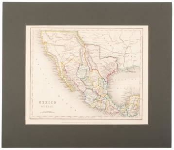
Sold2020Map of Mexico and Texas c.1845Heading: (Texas) Author: Wyld, James Title: Republic of Mexico and Texas Place Published: London Publisher: Date Published: c.1845 Description: Engraved map, with Mexico portionSee Sold Price
Sold2020Mexico with a large independent Texas, c.1845 mapHeading: Author: Gilbert, James Title: Mexico & Texas Place Published: London Publisher:Grattan & Gilbert Date Published: c.1845 Description: Engraved map, hand-colored in outliSee Sold Price
Sold20201854 Black's Map of Mexico, Texas and California --Title/Content of Map: 1854 Black's Map of Mexico, Texas and California -- Mexico, California, Texas Date: 1854, Edinburgh Cartographer: A & C Black Size: 10 X 14.5 in. This is a very nice map of MexicSee Sold Price
Sold2021Tallis, John (Pub) 1852 Map. Mexico, California & TexasSteel Engraved Map with Original Outline Hand Color Published 1852-56 by John Tallis, London for "The Universal Pronouncing Dictionary" by Thomas Wright. Drawn & Engraved by John Rapkin. Centre fold aSee Sold Price
Sold2017J. H. Colton: Map of Mexico & Texas, 1854.Mexico (includes part of Texas). J. H. Colton, 1854. 12.75 x 16. From the 1856 second edition of Colton’s Atlas of the World. Nice color and good impression. Clean. Hint of edge toning at sides. TwoSee Sold Price
Sold2020CAREY, HENRY CHARLES; and LEA, ISAAC. Geographical,CAREY, HENRY CHARLES; and LEA, ISAAC. Geographical, Statistical, and Historical Map of Mexico. Double-page engraved map of Mexico, Texas, and parts of the southwestern United States with border panelsSee Sold Price
Sold2022MEXICO CALIFORNIA TEXAS. Gold rush district. TX Republic.TALLIS/RAPKIN 1851 mapTITLE/CONTENT OF MAP: 'Mexico, California & Texas' The map indicates the gold country of the California gold rush which had started 2 years earlier. The key indicates that "the newly discovered Gold dSee Sold Price
Sold2023CARL FLEMMING (c. 1840-1879) A REPUBLIC OF TEXAS MAP, "Mexico, Mittel America, Texas," GLOGAU, CIRCACARL FLEMMING (c. 1840-1879) A REPUBLIC OF TEXAS MAP, "Mexico, Mittel America, Texas," GLOGAU, CIRCA 1846, a German lithograph on paper with hand color showing territories claimed by the Republic of TSee Sold Price
Sold2024Map of Mexico (California & Texas) by John Tallis, 1851Title/Content of Map: Map of Mexico (California & Texas) by John Tallis, 1851 Date Printed: 1851 Cartographer: John Tallis Material/Medium: Engraving Size: 11 x 14" John Tallis was a British map publiSee Sold Price
Sold2017Meyer: Antique Map of Mexico & Independent Texas, 1845Map: Neueste Karte von Mexico Cartographer: Bibliographischen Instituts. Place & Date: Hildburghausen / 1845 Size: 14 1/8" x 11 3/8" Condition: original outline color; overall age toning; water stainsSee Sold Price
Sold20211863 Map of Mexico including TexasBeautiful example of Johnson’s 1863 map of Mexico which includes nearly the full state of Texas. Bright and clean with decent margins. Vivid original hand coloring. New Mexico and Arizona are in earSee Sold Price
Sold2023Williamson, Lieut. R. S. 1856 Map. California, New Mexico, Texas, Mexico"United States & Mexican Boundary Survery" Lithograph Map Published 1853-61, Washington for "Reports of explorations and surveys, to ascertain the most practicable and economical route for a railroadSee Sold Price
2022Scarce 1833 Finley map of Mexico – fine exampleExtremely scarce map of Mexico depicting Texas territory just three years before it gained its independence. Shows major portion of western America still belonging to Mexico, including New Albion andSee Sold Price
Sold2023Scarce 1833 Finley map of Mexico – fine exampleExtremely scarce map of Mexico depicting Texas territory just three years before it gained its independence. Shows major portion of western America still belonging to Mexico, including New Albion andSee Sold Price
Sold2022JOHN TALLIS (1817-1876) A 'GOLD RUSH' MAP, "Mexico,JOHN TALLIS (1817-1876) A 'GOLD RUSH' MAP, "Mexico, California and Texas," LONDON, EDINBURGH AND DUBLIN, CIRCA 1851, hand-colored lithograph on paper, "The Illustrations by H. Warren & Engraved by J.See Sold Price
Sold20231814 map of Mexico showing Provincia Texas, M. CareyExtremely scarce and desirable map of Mexico or “New Spain” from Mathew Carey’s rare 1816 General Atlas. One of the earliest maps of Mexico published in America. Shows “ProvinSee Sold Price
Sold20231842 Greenleaf Map of Texas, Mexico and Central America -- The United States of MexicoTitle: 1842 Greenleaf Map of Texas, Mexico and Central America -- The United States of Mexico Cartographer: J Greenleaf Year / Place: 1842, Brattleboro, VT Map Dimension (in.): 12.4 X 10.7 in. This isSee Sold Price
Sold2018Spanish North America. THOMSON. Texas, Mexico &TITLE/CONTENT OF MAP: 'Spanish North America [northern part]' A large map of Texas, Mexico and the American Southwest, published in Edinburgh by John Thompson, based on the explorations of Humboldt anSee Sold Price
2024Spanish North America. THOMSON. Texas, Mexico & Southwestern USA 1817 mapTITLE/CONTENT OF MAP: Spanish North America [northern part] A large map of Texas, Mexico and the American Southwest, published in Edinburgh by John Thompson, based on the explorations of Humboldt andSee Sold Price
Sold2023Spanish North America. THOMSON. Texas, Mexico & Southwestern USA 1830 mapTITLE/CONTENT OF MAP: Spanish North America [northern part] A large map of Texas, Mexico and the American Southwest. There are extensive observations of Native American Indian settlements and huntingSee Sold Price
Sold2022(REPUBLIC OF TEXAS.) John M. Niles; and Lorraine T. Pease. A Map of Mexico and the Republic of(REPUBLIC OF TEXAS.) John M. Niles; and Lorraine T. Pease. A Map of Mexico and the Republic of Texas. Hand-colored engraved map of Mexico, an independent Texas, and part of the American southeast. 13&See Sold Price
Sold20221747 Mexico, California, New Mexico, Texas Original Antique Map by Emanuel Bowen1747 Mexico, California, New Mexico, Texas Original Antique Map by Emanuel BowenSee Sold Price
Sold20171835 MAP OF MEXICO SHOWING PROVINCE OF TEXASFramed map of "Mexico & c.", "Published by Henry Fisher, Caxton , London, c. 1835", "Jas. Bingley, sculp", hand colored Mexican states including Texas shown as part of the "Internal Provinces", sight:See Sold Price
Sold2018LaPie / Tardieu: Antique Map of US, Texas, Mexico, 1809Map: Mexique Cartographer: P. LaPie / Tardieu Place & Date: Paris / 1809/1812 Size: 11 7/8" x 8 3/4" Condition: outline color; light overall age toning, otherwise beautifully preserved A detailed mapSee Sold Price
Jun 12Dan Morphy AuctionsBRUE'S MONUMENTAL WALL MAP OF TEXAS, UPPER CALIFORNIA & MEXICO, C. 1845US$500
Jun 02Schilb Antiquarian Rare Books1848 RARE Halls of Montezumas MEXICO Texas America War Zachary Taylor BattlesUS$1(1 bid)
6 days LeftJasper521887 Cram Map of Texas [verso] Indian Territory [verso] Arkansas -- Texas [verso] Indian Ty. [verso]US$95
6 days LeftJasper521898 Rand McNally Map of Texas [verso] Indian Territory and Oklahoma -- Texas [verso] Oklahoma andUS$70
11 hrs LeftRail & Road AuctionsEight Southwestern Railroad 1912 Annual Passes - Trinity & Brazos Valley, Kansas City Southern, FortUS$50
May 16Potter & Potter AuctionsSTORM, Mark. Official Texas Brags Map of North America. 194...US$200(1 bid)
Jun 02Schilb Antiquarian Rare Books1849 TEXAS 1ed Mexican War Porter Annexation Mexico Americana Peace TreatiesUS$2(2 bids)
May 17LEAP Auctions40 West Texas & New Mexico Authentic Arrowheads & Bird Point Artifacts in Display CaseUS$20(1 bid)
4 days LeftSchilb Antiquarian Rare Books1848 Halls of Montezumas MEXICO America War Zachary Taylor Texas Alamo RAREUS$82(5 bids)


![Spanish North America. THOMSON. Texas, Mexico &: TITLE/CONTENT OF MAP: 'Spanish North America [northern part]' A large map of Texas, Mexico and the American Southwest, published in Edinburgh by John Thompson, based on the explorations of Humboldt an](https://p1.liveauctioneers.com/5584/132181/67157544_1_x.jpg?height=310&quality=70&version=1543975692)
![Spanish North America. THOMSON. Texas, Mexico & Southwestern USA 1817 map: TITLE/CONTENT OF MAP: Spanish North America [northern part] A large map of Texas, Mexico and the American Southwest, published in Edinburgh by John Thompson, based on the explorations of Humboldt and](https://p1.liveauctioneers.com/5584/320546/172232524_1_x.jpg?height=310&quality=70&version=1709072904)
![Spanish North America. THOMSON. Texas, Mexico & Southwestern USA 1830 map: TITLE/CONTENT OF MAP: Spanish North America [northern part] A large map of Texas, Mexico and the American Southwest. There are extensive observations of Native American Indian settlements and hunting](https://p1.liveauctioneers.com/5584/309982/165835454_1_x.jpg?height=310&quality=70&version=1700599538)


![1887 Cram Map of Texas [verso] Indian Territory [verso] Arkansas -- Texas [verso] Indian Ty. [verso] (1 of 3)](https://p1.liveauctioneers.com/5584/328338/176911685_1_x.jpg?height=282&quality=70&version=1715113718)
![1898 Rand McNally Map of Texas [verso] Indian Territory and Oklahoma -- Texas [verso] Oklahoma and (1 of 2)](https://p1.liveauctioneers.com/5584/328338/176911581_1_x.jpg?height=282&quality=70&version=1715113718)


