Sold20181850 MAPS Atlas Geography Illustrated Jerusalem CHINA1850 MAPS Atlas Geography Illustrated Jerusalem CHINA 8v Malte-Brun Conrad Malte-Brun was a French geographer and cartographer known for his impressive journal-like atlases and geography books. UnfortSee Sold Price
Sold20181850 McDowall Diamond Maps ATLAS Geography England1850 McDowall Diamond Maps ATLAS Geography England Scotland Ireland World Color A collection of 19th-century McDowall maps. These four maps are extremely desirable, hand-colored views. Maps include: �See Sold Price
Sold20181805 ATLAS Maps Universal Geography William Guthrie Ill1805 ATLAS Maps Universal Geography William Guthrie Illustrated Navigation Asia William Guthrie was well known during the mid-18th-century for his many contributions to world history, especially throuSee Sold Price
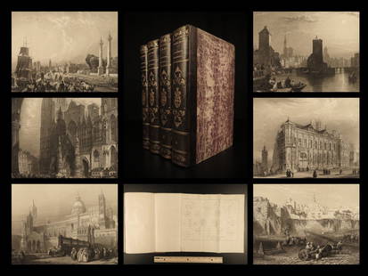
Sold20191843 Geography WORLD VIEWS Atlas Illustrated Jerusalem1843 Geography WORLD VIEWS Atlas Illustrated Jerusalem Israel India 6v Malte-Brun Conrad Malte-Brun was a French geographer and cartographer known for his impressive journal-like atlases and geographySee Sold Price
Sold20191752 INDIA Voyages MAPS Atlas Asia JAPAN China1752 INDIA Voyages MAPS Atlas Asia JAPAN China Philippines Geography The ‘General History of Voyages’ by abbe Prevost is one of the largest and most impressive collections of stories of expeditionSee Sold Price
Sold20181768 Geography ATLAS MAPS California Island Asia China1768 Geography ATLAS MAPS California Island Asia China 17 MAPS A rare 18th-century geographical treatise by Jean Baptiste Gibrat. This work features 17 impressive folding, engraved maps. Little is knoSee Sold Price
Sold20201752 Voyages INDIA MAPS Atlas JAPAN China Asia1752 Voyages INDIA MAPS Atlas JAPAN China Asia Philippines Geography Prevost The ‘General History of Voyages’ by abbe Prevost is one of the largest and most impressive collections of stories of exSee Sold Price
Sold2023Britannica International Atlas 1966, illustrated, Geography, History, Maps"Encyclopaedia Britannica International Atlas. Political-Physical Maps, World Distributions and World Political Geography, Geographical Summaries, Geographical Comparisons, Glossary and Index to PolitSee Sold Price
Sold20191766 Geography ATLAS Maps La Croix Francois & Blanchard1766 Geography ATLAS Maps La Croix Francois & Blanchard Illustrated A fine collection of 18th century geography texts – famous works by Blanchard, Abbe Francois, and De La Croix. This lot includes iSee Sold Price
Sold20181747 Voyages ATLAS MAPS Caribbean AFRICA Slavery1747 Voyages ATLAS MAPS Caribbean AFRICA Slavery Prevost Illustrated Geography The ‘General History of Voyages’ by abbe Prevost is one of the largest and most impressive collections of stories ofSee Sold Price
Sold2022Petermann, Augustus 1850 Physical Map. Ethnographic MapSteel Engraved Map Published 1850, London for "The Atlas of Physical Geography" by Augustus Petermann and Thomas Milner. Paper Size: 14.5 x 10.5 inch (37 x 27cm) A few minor marks in margin. Good CondSee Sold Price
Sold2022Petermann, Augustus 1850 Physical Map. British IslesSteel Engraved Map Published 1850, London for "The Atlas of Physical Geography" by Augustus Petermann and Thomas Milner. Paper Size: 14.5 x 10.5 inch (37 x 27cm) Good ConditionSee Sold Price
Sold2022Petermann, Augustus 1850 Physical Map. Palestine & Adjacent CountriesSteel Engraved Map Published 1850, London for "The Atlas of Physical Geography" by Augustus Petermann and Thomas Milner. Paper Size: 14.5 x 10.5 inch (37 x 27cm) Good ConditionSee Sold Price
Sold20181759 Barrow Geography Dictionary ATLAS MAPS Syria1759 Barrow Geography Dictionary ATLAS MAPS Syria Africa Coffee Tobacco HUGE FOLIO John Barrow was an 18th-century English naval historian remembered for his illustrated dictionaries. This tome from BSee Sold Price
Sold20221887 Mitchell ATLAS 23 MAPS America Color Illustrated Pennsylvania Geography1887 Mitchell ATLAS 23 MAPS America Color Illustrated Pennsylvania Geography The name Mitchell has long been synonymous with 19th-century maps; in fact, Mitchell maps are often considered the best ofSee Sold Price
Sold20221841 BEAUTIFUL Geography by Malte-Brun Illustrated1841 BEAUTIFUL Geography by Malte-Brun Illustrated Jerusalem Edinburg Ruins 4v Conrad Malte-Brun was a French geographer and cartographer known for his impressive journal-like atlases and geography boSee Sold Price
Sold20201857 ATLAS Colton Fitch COLOR MAPS School Geography1857 ATLAS Colton Fitch COLOR MAPS School Geography Cotton Slavery Illustrated “Colton and Fitch’s Modern School Geography” is an interesting school text for children to teach geography of the dSee Sold Price
Sold20191866 MAPS Atlas Appleton Companion Travel Handbook1866 MAPS Atlas Appleton Companion Travel Handbook Geography United States Color A rare and finely illustrated atlas companion by Richards and Appleton. This Civil War-era work features four enormousSee Sold Price
Sold2023THE ROYAL ILLUSTRATED ATLAS OF MODERN GEOGRAPHYTHE ROYAL ILLUSTRATED ATLAS OF MODERN GEOGRAPHYIntroduction by Dr. N. Shaw, Secretary to the Royal Geographical Society, A. Fullarton & Co., London and Edinburgh, circa 1862. Numerous maps. Tooled andSee Sold Price
Sold2016G.H. SWANSTON MAP OF BRITISH WEST INDIES 1872From The Royal Illustrated Atlas Of Modern Geography, 1862.1st edition 1864; published in 27 parts 1854-62. The date of 1872 is estimated by the Australia map; all the maps are undated and probably daSee Sold Price
Sold20181882 Hardesty Atlas of the USA, Bible Geography andTitle/Content of Map: 1882 Hardesty Atlas of the USA, Bible Geography and Lawrence Co., Ohio -- Historical Hand-Atlas Illustrated, Containing Large Scale Copper Plate Maps of Each State… Together wiSee Sold Price
Sold2019Tallis & Rapkin Map of The British IslesJ. & F. Tallis (Fl 1850's). The British Isles. Engraved map with hand color in outline from the Illustrated Atlas. London, Edinburgh & Dublin, c. 1851. 10 1/2" x 14 7/8" sheet.See Sold Price
Sold2019Blackie & Weller 1882 Pair of Maps of China"China" and "The Chinese Empire and Japan" Lithograph Maps Published 1882 by Blackie & Son, London for "The Comprehensive Atlas & Geography of the World" by W. G. Blackie. Maps by Edward Weller. CentrSee Sold Price
Sold20211882 Map of ChinaTitle: 1882 Map of China Author: Blackie Medium: Ink on Paper Dimensions: 15"X22" Description: Map of China dated 1882. Part of the Comprehensive Atlas & Geography of the World. Engraved by Edwin WellSee Sold Price
4 days LeftJasper521896 STANFORD'S COMPEDIUM of GEOGRAPHY & TRAVEL ASIA 2 VOLS. antique ILLUSTRATEDUS$220
May 17Albion AuctionsBlackie (Pub) 1882 Folio Map. Canada - Quebec, Nova Scotia, New Brunswick, Prince EdwardUS$5