Sold2016Antique Hand Colored Map - Carte D'AfriqueParisian hand colored map of Africa 1772; 20in. X 25.25in.See Sold Price
Sold2021Framed MapFramed map "CARTE / D" AFRIQUE....". Sight 19 1/2" x 25 1/2", frame overall 21 1/2" x 27 1/2".See Sold Price
Sold2019Charles Francis de Beaupre (1766-1854, Paris), "CarteCharles Francis de Beaupre (1766-1854, Paris), "Carte Geographique, Statistique, et Historioque de Porto-Rico et lies Vierges Louis Guillaume (extensive history)," 1822, H. -20 3/4 in., W. - 27 in.See Sold Price
Sold2020Grp: 3 Maps of the Coast of AfricaGroup of three maps of the west coast of Africa by Guillaume Rouille (ca. 1518–1589): "Carte Reduite des Costes Occidentales d'Afrique," 1753; "Carte Generale de la Coste de Guinee," 1750; andSee Sold Price
Sold20221770 Bonne Map of Northern Africa -- Carte De La Partie Septentionale D'Afrique, ou De La Barbarie;Title: 1770 Bonne Map of Northern Africa -- Carte De La Partie Septentionale D'Afrique, ou De La Barbarie; Contenant Les Royaumes De Tripoli, De Tunis, D'Alger, De Fez Et De Maroc Cartographer: R BonnSee Sold Price
Sold2024Coste Occidentale d’Afrique…' Namibia South Africa Angola coast BELLIN 1746 mapCAPTION PRINTED BELOW PICTURE: Carte de la Côte Occidentale d’Afrique depuis le Xle. degré de Latitude Meridionale, jusqu’au Cap de Bonne Esperance, Tirée de la Carte de l'OSee Sold Price
Sold20211787 Bonne Map of Barbary AfricaCarte De La Partie Septentrionale D'Afrique, ou de la Barbarie…, by Rigobert Bonne, published in Paris in 1787. Folding map, Very Good. Measures 15.5 x 10". Reserve: $20.00 Shipping: Domestic: Flat-See Sold Price
Sold2016Map of Asia. 1854.Print of hand colored steel engraving titled „Carte Physique & Politique de L’Asie“.Drawn by L. Dussieux.Engraved by unknown.From „Atlas General De Geographie physique, politique et historiqueSee Sold Price
Sold2016Map of Europe. 1854.Print of hand colored steel engraving titled „Carte de L’Europe”.Drawn by L. Dussieux. Engraved by unknown.From „Atlas General De Geographie physique, politique et historique par L. Dussieux.See Sold Price
Sold2016Map of the Arabs. 1854.Print of hand colored steel engraving titled „Carte pour servir a L’histoire des Arabes“.Drawn by L. Dussieux.Engraved by unknown.From „Atlas General De Geographie physique, politique et histoSee Sold Price
Sold2016Map of Roman Empire. Europe. 1854.Print of hand colored steel engraving titled „Carte de L’Empire Romain”.Drawn by L. Dussieux. Engraved by unknown.From „Atlas General De Geographie physique, politique et historique par L. DusSee Sold Price
Sold2016Map of Empire of Charlemagne. Europe. 1854.Print of hand colored steel engraving titled „Carte du Partage de L’Empire de Charlemagne“.Drawn by L. Dussieux.Engraved by unknown.From „Atlas General De Geographie physique, politique et hisSee Sold Price
Sold2016Map of Italy. Europe. 1854.Print of hand colored steel engraving titled „Carte pour servir a l’histoire del’Italie“.Drawn by L. Dussieux.Engraved by unknown.From „Atlas General De Geographie physique, politique et hisSee Sold Price
Sold20201782 Bonne Map of Eastern Africa and Madagascar --Title/Content of Map: 1782 Bonne Map of Eastern Africa and Madagascar -- Partie De La Cote Orientale D'Afrique avec l'Isle de Madgascar et le Cartes particulieres des Isles de France et de Bourbon . .See Sold Price
Sold2023Original Civil War CDV Photograph 1st Lieut. J. KINSERThese cartes de visite (CDV) photographs were usually an albumen print mounted on a card and measured about 2 ½ wide x 4” high. First patented in 1854, these photos became very popular duSee Sold Price
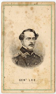
Sold2023Original Civil War CDV Photograph Gen. R. E. LEEThese cartes de visite (CDV) photographs were usually an albumen print mounted on a card and measured about 2 ½ wide x 4” high. First patented in 1854, these photos became very popular duSee Sold Price
Sold2023Original Civil War CDV Photograph Military Ident.These cartes de visite (CDV) photographs were usually an albumen print mounted on a card and measured about 2 ½ wide x 4” high. First patented in 1854, these photos became very popular duSee Sold Price
Sold2023Original Civil War CDV Photograph Gen. R. E. LEEThese cartes de visite (CDV) photographs were usually an albumen print mounted on a card and measured about 2 ½ wide x 4” high. First patented in 1854, these photos became very popular duSee Sold Price
Sold2023Original Civil War CDV Litho M. Gen. W. S. ROSECRANZThese cartes de visite (CDV) photographs were usually an albumen print mounted on a card and measured about 2 ½ wide x 4” high. First patented in 1854, these photos became very popular duSee Sold Price
2021KAWS - Untitled IX (Urge)Artist: KAWS Title: Untitled IX (Urge) Year: 2020 Dimensions: 17 1/2in. by 12in. Edition: From the Rare Limited Edition of 250 Suite: Urge Medium:See Sold Price
2021Georges Braque - Choucas Filet NoirArtist: Georges Braque Title: Choucas Filet Noir Year: 1962 Dimensions: 18 5/8in. by 14 1/4in. Edition: From the Rare Limited Edition of 70 Publisher: Louis BrSee Sold Price
Sold2022Platinum diamond ring set 7 large brilliant cut diamonds: Total carat weight of diamonds 2.3ct, eachPlatinum diamond ring set 7 large brilliant cut diamonds: Total carat weight of diamonds 2.3ct, each stone measuring 4.46mm wide. Gross weight 10.1g, UK ring size M.See Sold Price
Sold2022Ottilie Reylaender(1882 Wesselburen/Holstein - 1965 Berlin) attr.; Mädchen im Teufelsmoor und Frau hinter Birken Doppelseitiges, um 1900 in Worpswede entstandenes Gemälde. Ab 1898 war Reylaender iSee Sold Price
Sold2018CONTINENTAL PORCELAIN URNS, LOT OF TWOCONTINENTAL PORCELAIN URNS, LOT OF TWO, having ornately painted polychrome hunting scenes including one scene with a boar below flared rims, molded ram's head on handles, lacking bolts for raised squaSee Sold Price
5 days LeftJasper52Carte d'Afrique. Africa Soudan Zanzibar. LAPIE 1831 old antique map plan chartUS$80
5 days LeftJasper52Carte de L'Algérie et de la Régence de Tunis' ANDRIVEAU-GOUJON Algeria 1850 mapUS$100
5 days LeftJasper52Carte de la partie septentrionale d'Afrique, ou de la Barbarie… BONNE 1780 mapUS$25
5 days LeftJasper52Coste Orientale d’Afrique…' South Africa. Mozambique channel. BELLIN 1746 mapUS$25
5 days LeftJasper52Coste Orientale d’Afrique'. South Africa Mozambique BELLIN/SCHLEY 1747 mapUS$25
5 days LeftJasper52Coste Occidentale d’Afrique…' Arguin Bay Cap Blanc Mauritania. BELLIN 1746 mapUS$30
5 days LeftJasper52Coste Occidentale d’Afrique'. Bay of Arguin, Mauritania. BELLIN/SCHLEY 1747 mapUS$30
Featured5 days LeftJasper52Coste Occidentale d’Afrique…' Namibia South Africa Angola coast BELLIN 1746 mapUS$45
5 days LeftJasper52Coste Occidentale d’Afrique…' West Africa. Gulf of Guinea. BELLIN 1746 mapUS$55
Featured5 days LeftJasper52Coste Orientale d’Afrique…' East Africa Kenya Tanzania Somalia. BELLIN 1746 mapUS$80
5 days LeftJasper52Partie de la Coste d'Afrique depuis Tanit…' Southern Mauritania BELLIN 1746 mapUS$20
5 days LeftJasper52Partie de la Coste d'Afrique'. Southern Mauritania BELLIN/SCHLEY 1747 old mapUS$20
5 days LeftJasper52Carte du Canal de Mosambique…. Madagascar Bonne Esperance. BONNE 1780 mapUS$30
2 days LeftCarlsen Gallery, Inc.2 CARTE DE VISTES - 1 CIVIL WAR AMPUTEES & VERMONT CAVALRY SOLDIER WITH SABERUS$200(4 bids)
2 days LeftSchilb Antiquarian Rare Books1854 MEDICINE & Surgery Practice of Physic by Thomas Watson Health HygieneUS$26(4 bids)
2 days LeftCarlsen Gallery, Inc.4 CARTE DE VISTE INC. SGND MAJ. PRUYN, NY , WESLEY MERRITT, GEN MCCLELLAN & SGND DAVID W. PAYNESUS$100(1 bid)
2 days LeftCarlsen Gallery, Inc.6 CARTE DE VISTE INC. MAJOR IN NY INFANTRY, CAVALRY MAN W/ TENNESSEE BACK STAMP & OTHER OFFICERSUS$200(1 bid)
2 days LeftCarlsen Gallery, Inc.8 CARTE DE VISITES INC. GRANT, SCOTT, SHERIDAN, KILPATRICK, MCCLELLAN, ETC.US$200