Sold20211855 Map of Charleston and SavannahTitle: 1855 Map of Charleston and Savannah Medium: Ink on Paper Dimensions: 17"X14.5" Description: Map of Charleston and Savannah dated 1855. Printed and published by Colton in New York. Key upper midSee Sold Price
Sold20191855 Colton Map of Charleston and Savannah -- The CityTitle/Content of Map: 1855 Colton Map of Charleston and Savannah -- The City of Savannah Georgia [with] The City of Charleston South Carolina Date: 1855, New York Cartographer: J Colton Size: 11.8 X 1See Sold Price
Sold20202 antique framed Southern maps2 antique framed maps: Map of South Carolina in German dated 1845. Map of Savannah and Charleston published by G.W and C.B Colton & Co and dated 1855. Overall size measures 25 1/2"h x 28"w and the papSee Sold Price
Sold2019Colton's Savannah/Charleston Map [Southern Cities]Colton's Savannah and Charleston Map; Savannah on the left, Charleston on the right. J. H. Colton Cartographer. Published by J. H. Colton, New York. Stamped 'Entered according to Act of Congress in thSee Sold Price
Sold20211855 MAP THE CITY OF CHARLESTON, SOUTH CAROLINAMap of the City of Charleston, South Carolina , published by JH Colton & Co, New York in 1855. Good condition. Paper size 11 1/2"x7". Professionally framed and matted. In frame 11 1/2"x15 1/2"x1". WeiSee Sold Price
Sold2019J. H. Colton (1800-1893), "City of Savannah andJ. H. Colton (1800-1893), "City of Savannah and Charleston," 1855, hand colored, H.- 14 in., W.- 17 1/2 in.See Sold Price
Sold2022ANTIQUE MAPS, 3 PCS, H 6.25"-14.75", CHARLESTON, SAVANNAH & YORKSHIREANTIQUE MAPS, 3 PCS, H 6.25"-14.75", CHARLESTON, SAVANNAH & YORKSHIRE A selection of three antique maps. Includes one hand-colored 'Parts of North and South Carolina' coastal map (H 14.75" x W 13"), oSee Sold Price
Sold20211856 COLTON MAP CHARLESTON SCMap is from Colton's Atlas Of The World published by J.H. Colton And Company, 1856. Map was of Charleston, South Carolina and Savannah, Georgia. Framed with only Charleston showing. Professionally fraSee Sold Price
2021Savannah, Georgia & Charleston, South Carolina antiqueTITLE OF MAP (NOT PRINTED ON THE PAGE):'Colton's the City of Savannah, Georgia and the City of Charleston, South Carolina' The top image on the right hand side shows the entire map. To view a close upSee Sold Price
Sold2024Eleven Port Series Books with Fold Out Maps - No. 9 Through No. 23 - Army Corps of EngineersA group of Port Series books by the War Department US Army Corps of Engineers and Maritime Commission spanning 1932 to 1940. Includes No. 9 Port of Charleston S.C., No. 10 Ports of Savannah and BrunswSee Sold Price
Sold2020SOUTHERN STATES TRADE ROUTE MAPLarge Framed Trade Route Map showing waterways and towns from the Mississippi River to Charles Town. Geographic Area Covered: Southern States, South Carolina,Santee River Valley, Savannah River ValleySee Sold Price
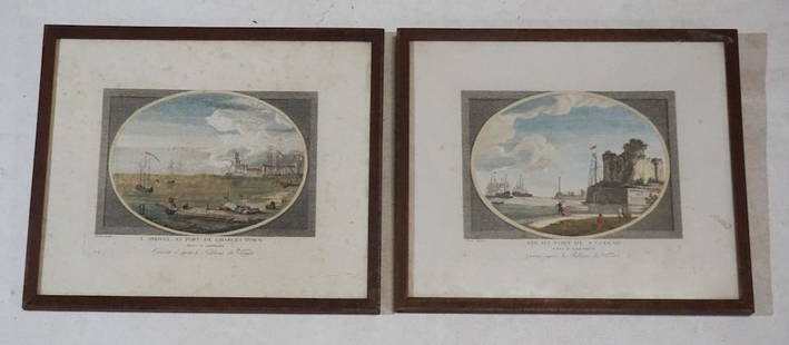
Sold202318th Century Engravings of Charleston & SavannahBy Claude Joseph Vernet engraved in London 1780. Two very nicely rendered and hand colored examples. Each with well defined plate lines and nice bold colors throughout. Framed: H11 1/8" W13 1/4" RecenSee Sold Price
Sold2019Scarce Colton 1855 map of Texas, Johnson/BrowningScarce large map of Texas with 1855 date, but with Johnson & Browning imprint. The Johnson & Browning imprint was found in only the 1859 Colton atlas and 1860 and 1861 Johnson Family atlases. This mapSee Sold Price
Sold2023Scarce 1855 map of U.S. w/large territorial bordersScarce and collectible 1855 example of Cowperthwait, Desilver & Butler map of the U.S., at a time when the west was experiencing some of its most unusual US territorial configurations. Oregon TerritorSee Sold Price
Sold2022Sharp 1855 map of Ireland from J. H. ColtonBeautiful map of the emerald isle from Colton’s first 2-volume edition of his Atlas of the World. Derived from an earlier wall map by Colton and D. Griffing Johnson. Shows the four main provinceSee Sold Price
Sold2019Scarce 1855 map of Calif. – Johnson & BrowningFrom an 1855 edition of Colton’s General Atlas. However, since the imprint of Johnson & Browning appears as publishers of the map, the atlas would have been published no earlier than 1856. Hand coloSee Sold Price
Sold2018Pre Civil War South Carolina Map Charleston 1847Original hand colored map in overall good condition. Not a repro or restrike. Recently matted and framed using conservation materials. Framed dimensions 23 x 19 inches.See Sold Price
Sold20211855 Map of South AfricaAuthor: Colton Title: 1855 Map of South Africa Medium: Ink on Paper Dimensions: 18.5"X16" Map of the South Africa dated 1855. Engraved and published by J.H. Colton in New York. Color coded for territoSee Sold Price
Sold20191807 Map Charleston, South CarolinaPublished Philadelphia by C.P. Wayne. The piece titled ÒPlan of the Siege of Charleston in S. CarolinaÓ. Sight size: H10" W15" (without frame)See Sold Price
Sold20231855 map of N. America showing Discovery, Conquest, ColonizationScarce 1855 Von Spruner map of North America, with particular attention paid to the Discovery, Conquest and Colonization of the region. This Justus Perthes map includes Nation states, European possessSee Sold Price
Sold2022Uncommon 1855 map of Arkansas“A New Map of Arkansas with its Counties, Towns, Post Offices, &c.” pub. by Cowperthwait, Desilver & Butler in their 1855 New General Atlas. Maps by Cowperthwait, Desilver & Butler are theSee Sold Price
Sold20221855 Map of Maine from scarce Cowperthwait atlasHand-colored map of the state of Maine by Thomas, Cowperthwait from the increasingly hard-to-find New Universal Atlas, published 1855 by Cowperthwait, Desilver & Butler. This is the early edition of tSee Sold Price
Sold20191855 Map North America by G. Virtue1855 map of North America by G. Virtue. Measures 13.375 in. x 9.875 in. G-VG/VG. Unframed, loose and not glued or mounted. If lot is absent of a condition report a condition report may be requested viSee Sold Price
Sold20211855 Map of Western Oregon Territory -- Map of theTitle: 1855 Map of Western Oregon Territory -- Map of the Territory of Oregon West of the Cascade Mountains Cartographer: US State Surveys Year / Place: 1855, Salem Map Dimension (in.): 18 X 10.5 in.See Sold Price
Jun 07Freeman's | Hindman[MAP]. SARTINE, Antoine Plan de la Barre et du Havre de Charles-Town...1778. RARE REVOLUTIONARY WARUS$1,000(1 bid)
Jun 23Schilb Antiquarian Rare Books1855 San Francisco 1st ed California Gold Rush Illustrated MAPS Soule IndiansUS$1(1 bid)


![1855 Colton Map of Charleston and Savannah -- The City: Title/Content of Map: 1855 Colton Map of Charleston and Savannah -- The City of Savannah Georgia [with] The City of Charleston South Carolina Date: 1855, New York Cartographer: J Colton Size: 11.8 X 1](https://p1.liveauctioneers.com/5584/138633/70306064_1_x.jpg?height=310&quality=70&version=1553637454)

![Colton's Savannah/Charleston Map [Southern Cities]: Colton's Savannah and Charleston Map; Savannah on the left, Charleston on the right. J. H. Colton Cartographer. Published by J. H. Colton, New York. Stamped 'Entered according to Act of Congress in th](https://p1.liveauctioneers.com/5755/154409/77936944_1_x.jpg?height=310&quality=70&version=1573094011)


![[MAP]. SARTINE, Antoine Plan de la Barre et du Havre de Charles-Town...1778. RARE REVOLUTIONARY WAR (1 of 1)](https://p1.liveauctioneers.com/197/329395/177650540_1_x.jpg?height=282&quality=70&version=1715364962)


