Sold20191859 Beeton Chronological Chart with World Map -- AnTitle/Content of Map: 1859 Beeton Chronological Chart with World Map -- An Historical Chronological Chart with inset of The World in Mercators Projection Date: 1859 c., London Cartographer: S Beeton SSee Sold Price
Sold2020Antique Adams Syn Chronological Map of HistoryAntique Adams Syn Chronological Chart or Map of History Book of Oversized Coated Color Illustrated Cloth Continuous Map of the World with History , Dated 1884. Fifth edition by Colby & Co. Publishers,See Sold Price
Sold2022Adams Syn Chronological Chart/ Map of History, 1976Description: Adams Syn Chronological Chart or Map of History, 1976, printed by 'Strobridge & Co. Lith. Cincinnati, O.', copyright 1876 'Centennial Edition', a chronological chart of ancient, modeSee Sold Price
Sold2022History of Civilization 4 Panel Decoupage ScreenAdams syn chronological chart of map of history. Closed screen measures approx 66H x 17W inches. Wear to piece consistent with use and age. Some peeling of paint and scratches to piece. Screen, room dSee Sold Price
Sold2022A. Dunsford, hand-drawn world map, 1859A. Dunsford, hand-drawn world map, 1859, A. Dunsford (19th c., likely American), ink, gouache and watercolor on paper, mounted on linen, dated "Xmas 1859" and marked "A. Dunsford - Wellington Academy"See Sold Price
Sold20191821 Chart of the World Map This is a mercator'sThis is a mercator's projection of North America by John Purdy, published Jan 1, 1821 by Richard Holmes Laurie, measures 40" wide by 26.5" tall.See Sold Price
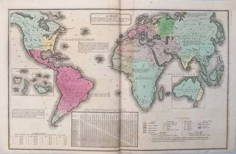
Sold20211835 Smith World Map -- A Chart Exhibiting the ActualTitle: 1835 Smith World Map -- A Chart Exhibiting the Actual and Comparative Size of each Country, Nation, or Kingdom; its Population as a Whole and to a Square Mile. Also the Different States of SociSee Sold Price
Sold2017Smith: Antique Map of the World, 1835Map: 1835 Smith World Map -- A Chart Exhibiting the Actual and Comparative Size of each Country, Nation, or Kingdom; its Population as a Whole and to a Square Mile. Also the Different States of SocietSee Sold Price
Sold2024Henry Bostwick, 1827, bound atlas "A Historical,Chronological and genealogical Chart" exhibiting maps of "Ancient Countries, as well as a new scale of time charts" developed by Bostwick including countries in the Mediterranean, Greece, France, andSee Sold Price
Sold20201855 Johnston World Map with Comperative Chart ofTitle/Content: 1855 Johnston World Map with Comperative Chart of Rivers and Mountains -- The World in Hemispheres, with Comparative Views of the Heights of ths Principal Mountains and Lengths of the PSee Sold Price
Sold20231758 Map Chart of World TradewindsAn Accurate Chart of the World with the New Discoveries....Tradewinds.., by Thomas Kitchin, 1758. Large folding map, measures 17 x 13", Condition issues including creasing and repaired breaks at foldsSee Sold Price
Sold2022AJ Nystrom 2-Sided Chalkboard School Map, US & WorldLarge AJ Nystrom Roll Up 2 Sided Chalkboard Classroom Map Chart, US & World. Wonderful chart has maps of the United States and the World outlined in yellow on a black chalkboard backing. From the RoyaSee Sold Price
Sold2017Rand McNally: Antique World Map, Rivers & MountainsMap: Rand McNally World Map and Comperative Chart of Rivers and Mountains -- The World on Mercator's Projection [verso] Western Hemisphere Cartographer: Rand McNally Year / Place: 1898, Chicago Map DiSee Sold Price
Sold2020Rivers Of Life or Faiths of Man J.G.R. Forlong ChartRivers Of Life or Faiths of Man J.G.R. Forlong Chart Book A huge coloured Chronological Chart of the Religions of the World by James George Roche Forlong. Approximately 25 3/16 x 19 7/16 inches.See Sold Price
Sold2020Philip, George C1900 Mixed Lot of 8 MapsIncl Asiatic Russia, Asia-Physical, France - North, France - Physical, Mediterranean, North Atlantic, Commercial Chart of the World, and Climatological. Lithograph Maps Published C1900, London for "PhSee Sold Price
Sold2023Perry, Matthew 1856 Large Map. Chart of the World. Track of the U.S Steam Ships"Chart of the World showing the Track of the U. S. Steam Frigates Mississippi, Susquehanna, and Powhatan" Large Folio Lithograph Map Published 1856, Washington for "Narrative of the Expedition of an ASee Sold Price
Sold2022WWII Factual Chart of WWII World War Two Asiatic-Pacific Operations MapFACTUAL CHART OF WORLD WAR II Asiatic-Pacific Operations folder and chart / poster with Generals and Admirals. The folder is 14 x 15 inches tall. The folding map poster itself is 38 x 57 inches. 1st eSee Sold Price
Sold2023Thomson, John (Pub) 1825 Map. Chart of the WorldCopper Engraved Map Published 1825 by John Thomson, Edinburgh for "The Edinburgh School Atlas" by N. R. Hewitt. Maps Engraved by Hewitt. Original Outline Hand Colour. Rare. Paper Size: 10.5 x 8 inch (See Sold Price
Sold2021Thomson, John (Pub) 1825 Map. Chart of the WorldCopper Engraved Map Published 1825 by John Thomson, Edinburgh for "The Edinburgh School Atlas" by N. R. Hewitt. Maps Engraved by Hewitt. Engraved Vignette in corner. Original Outline Hand Colour. RareSee Sold Price
Sold2023Russell & Barclay 1832 Hand Col Map. Chart of the WorldHand Colored Steel Engraved Map Published 1823-40, by Fisher & Son, "A Complete Atlas of the World" by John Russell et al. A Very Rare Work which is compiled from the same plates used in different ediSee Sold Price
Sold2023Russell & Barclay C1825 Antique Map. Chart of the World (On Mercator Proj.)Copper Engraved Map Published C1825., by Fisher & Son, "A Complete Atlas of the World" by John Russell et al. The companion Atlas to "A Complete and Universal English Dictionary" by James Barclay. PapSee Sold Price
Sold2019Chart of the World, On Mercators ProjectionTitle/Content of Map: Chart of the World, On Mercators Projection Date: 1815 ca. Cartographer: WYLD/HEWETT Size: 11.4Height - 17.4Width Publisher: JOHN THOMPSON & CO. Only named place in Mid-MississipSee Sold Price
Sold2017Chart of the World On Mercators Projection, 1796Map: Chart of the World On Mercators Projection Maker: Thomas & Andrews, Morse/Doolittle (Sculp) Publisher: Boston, 1796 Size: Quarto - 7.30 H x 10.00 W Inches Small map of the world. Shows LouisianaSee Sold Price
Sold2022Chart of the World on Mercator’s Projection, fromTitle/Content of Map: Chart of the World on Mercator’s Projection Date Printed: 1796 Cartographer: Thomas & Andrew Material/Medium: Engraving Size: 8 1/4 x 11" Description: Rare map by Isaiah ThomasSee Sold Price
7 days LeftJasper521816 MAP NORTHERN PART OF RUSSIA or MUSCOVY in EUROPE copper engraving ANTIQUEUS$35
2 days LeftPotter & Potter AuctionsPan American Airways World System Map. 1956. Art by John Br...US$200
2 days LeftPotter & Potter AuctionsAir France / Reseau Aerien Postal. 1948. Paris: Perceval. L...US$150
1 day LeftOriental Art AuctionsAL-IDRISI AND ROGER II, A MAP OF ASIA IN NUZHAT AL-MUSHTAQ, 17TH CENTURY€4,000
Jun 01Northgate Gallery, Inc.Vintage Baker Furniture George II Style Wing Back Arm Chairs, PairUS$200
3 days LeftAlbion AuctionsCooke, George 1801 Antique Map. World Hemispheres by ArrowsmithUS$20(3 bids)
21 hrs LeftJasper52Scandinavia Russia sea chart. Ports lighthouses. Arctic Ocean Bothnia 1918 mapUS$20
21 hrs LeftJasper52Scandinavia Russia sea chart. Ports lighthouses. Arctic Ocean Bothnia 1916 mapUS$20
2 days LeftPotter & Potter AuctionsSabena Belgian World Airways. 1969. Belgium: Marci/PV Pub. ...US$200
21 hrs LeftJasper52North Sea sea chart. Ports lighthouses mail routes. UK Norway &c LARGE 1952 mapUS$40


![Rand McNally: Antique World Map, Rivers & Mountains: Map: Rand McNally World Map and Comperative Chart of Rivers and Mountains -- The World on Mercator's Projection [verso] Western Hemisphere Cartographer: Rand McNally Year / Place: 1898, Chicago Map Di](https://p1.liveauctioneers.com/5584/108569/55677982_1_x.jpg?height=310&quality=70&version=1504123318)


