Sold20211876 MAPS Traveler’s Handbook in Europe Geography1876 MAPS Traveler’s Handbook in Europe Geography Fetridge Great Britain Russia “Harper’s Hand-book for Travellers in Europe” is a 19th-century travel guide for those touring European countrieSee Sold Price
Sold2023Reclus, Elisee C1880 Lot of 6 Antique Maps of EuropeIncl Belgium/Netherlands, Scandinavia, British Isles, Volcanoes of Central France, Russia, and Central Europe. Lithograph Map Published 1876-94, London for "The Universal Geography" by Elisee Reclus.See Sold Price
Sold2018BAEDEKER'S GUIDE & GUIDE THROUGH EUROPE CIRCA 1900Four antique travel guides complete with maps: Baedeker, Karl. Paris and Its Environs, with Routes from London to Paris, Handbook for Travelers: with 14 Maps and 42 Plans. 18th ed., Karl Baedeker, 191See Sold Price
Sold20191843 Folding Color German World Maps Europe Americas1843 Folding Color German World Maps Europe Americas Geography Austria RARE Three 19th-century world maps published in Vienna in 1843! Published for use in Austrian high schools, this atlas includes fSee Sold Price
Sold20231850s Dufour ATLAS 42 HUGE MAPS Europe ENORMOUS & RARE Geography Cartography1850s Dufour ATLAS 42 HUGE MAPS Europe ENORMOUS & RARE Geography Cartography Adolphe Dufour was a 19th-century French cartographer and map maker known for his highly detailed maps of European cities aSee Sold Price
Sold20171848 Houze ATLAS Geography 101 MAPS Europe Africa1848 Houze ATLAS Geography 101 MAPS Europe Africa America Hand-Colored England A rare 19th-century atlas filled with over 100 full-page maps hand-traced in color. These maps by Antoine Philippe HouzeSee Sold Price
Sold20211790 Geography Dictionary World MAPS Europe History1790 Geography Dictionary World MAPS Europe History French Laurence Echard Laurence Echards Geographic Dictionary is a rare, late 18th-century history of world. This book is organized much like a modeSee Sold Price
Sold20191866 MAPS Atlas Appleton Companion Travel Handbook1866 MAPS Atlas Appleton Companion Travel Handbook Geography United States Color A rare and finely illustrated atlas companion by Richards and Appleton. This Civil War-era work features four enormousSee Sold Price
Sold2019Group of Four Maps by Thomas Bowen (-1790), "A NewGroup of Four Maps by Thomas Bowen (-1790), "A New Acurate Map of North America… For Middleton's Compleat Geography," "Map of Europe," "A New Accurate Map of E. Moscovy or Russia in Europe," 174See Sold Price
Sold20191770 VOYAGES 17 ATLAS Maps Jesuits Asia Africa Europe1770 VOYAGES 17 ATLAS Maps Jesuits Asia Africa Europe USA Astronomy Geography An early printing of a rare geographic atlas filled with 17 folding maps! We do not find any other examples of this same eSee Sold Price
Sold2017Map of EuropeMap of Europe to Illustrate Olney's School Geography circa 1844 Size: 18.75 x 12 in No Reserve: This lot starts at $1 and has no reserve as a courtesy so that collectors can determine the true marketSee Sold Price
Sold20201734 ATLAS Vaugondy MAPS Geography Asia Africa Europe1734 ATLAS Vaugondy MAPS Geography Asia Africa Europe USA France Germany Collectors, of both maps and atlases, agree that Vaugondy maps are among the best and most accurate maps! The collection of 18tSee Sold Price
Sold20181780 VOYAGES 17 ATLAS Maps Geography Asia Africa Europe1780 VOYAGES 17 ATLAS Maps Geography Asia Africa Europe USA Vaugondy Collectors, of both maps and atlases, agree that Vaugondy maps are among the very best and most accurate maps! This collection of 1See Sold Price
Sold20201780 VOYAGES 17 ATLAS Maps Geography Asia Africa Europe1780 VOYAGES 17 ATLAS Maps Geography Asia Africa Europe USA Vaugondy Collectors, of both maps and atlases, agree that Vaugondy maps are among the best and most accurate maps! This collection of 18th-cSee Sold Price
Sold20191780 VOYAGES 17 ATLAS Maps Geography Asia Africa Europe1780 VOYAGES 17 ATLAS Maps Geography Asia Africa Europe USA Vaugondy Collectors, of both maps and atlases, agree that Vaugondy maps are among the very best and most accurate maps! This collection of 1See Sold Price
Sold20151913 Carl Crow “Traveler's Handbook for Chinaâ€,1913 Carl Crow “Traveler's Handbook for Chinaâ€, 1923 Edward Thomas Williams “China Yesterday & Todayâ€, both w/ original folding mapsSee Sold Price
Sold2019Goldsmith 1842 Group of 3 Maps. Europe, Asia, AfricaSteel Engraved Maps Published 1842, London for "Goldsmith's Grammar of Geography" by W. S. Kenny and the Rev. Goldsmith. Folds as issued. Paper Size: 7.5 x 6 inch (19 x 15cm) One with minor toning. TiSee Sold Price
Sold2022Kelly, Christopher 1816 Map. EuropeCopper Engraved Map Published 1816, London for "A New and Complete System of Universal Geography" by Christopher Kelly. Maps Engraved by Findlay, Wallis and others. Folds as issued. Paper Size: 16 x 1See Sold Price
Sold2022Kelly, Christopher 1836 Antique Map. EuropeCopper Engraved Map Published 1836, London for "A New and Complete System of Universal Geography" by Christopher Kelly. Maps Engraved by Findlay, Wallis and others. Paper Size: 10.5 x 8 inch (27 x 20cSee Sold Price
Sold2022Butler, Samuel 1842 Antique Map. EuropeSteel Engraved Map Published 1842, London for "An Atlas of Modern Geography" by Samuel Butler. Drawn & Engraved by Sidney Hall. Centre fold as published. Original outline hand colour. Paper Size: 10.5See Sold Price
Sold2024NAPOLEONIC EUROPE. French Revolution 1793- Bonaparte's abdication 1815 1876 mapCAPTION PRINTED BELOW PICTURE: 'Europe from the Revolution (1793) to the abdication of Napoleon Bonaparte 1815' DATE PRINTED: 1876 IMAGE SIZE: Approx 15.5 x 22.5cm, 6 x 8.75 inches (Medium) TYPE: AntiSee Sold Price
Sold2024Cooke, George 1801 Antique Map. EuropeCopper Engraved Map Published 1801-07 by Macdonald & Son, London for "Modern and Authentic System of Universal Geography" By George A. Cooke. Folds as issued. Paper Size: 12.5 x 10 inch (32 x 26cm) ApSee Sold Price
Sold2021Lochhead (Pub) 1811 Rare Map. EuropeCopper Engraved Map Published 1811 by William Lochhead, Berwick for "Modern Geography: And a Compendious General Gazetteer" Rare. Folds as issued. Paper Size: 12 x 10.5 inch (30 x 27cm) Some tone spotSee Sold Price
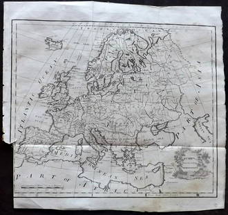
Sold2024Walker, John C1805 Antique Map. EuropeCopper Engraved Map Published C1805, London for "The Universal Gazetteer: Being a Concise Description" [Walker's Geography] by John Walker. Folds as issued. Paper Size: 10 x 8 inch (25 x 20cm) Some wrSee Sold Price
4 days LeftJasper52Europe. Austria-Hungary. East Roumelia. Ticino shown as Italian. HUGHES 1876 mapUS$20
4 days LeftJasper52Europe in the middle of the 16th Century (Period of the Reformation)' 1876 mapUS$20
1 day LeftSchilb Antiquarian Rare Books1869 ATLAS 42 MAPS America Africa Australia GERMANY Switzerland Sydow RAREUS$155(4 bids)
5 days LeftOriental Art AuctionsAL-IDRISI AND ROGER II, A MAP OF ASIA IN NUZHAT AL-MUSHTAQ, 17TH CENTURY€4,000
Featured4 days LeftJasper52EUROPE. Political. Austro-Hungarian Monarchy. Shipping routes. JOHNSTON 1906 mapUS$20
4 days LeftJasper52Decorative copperplate map of EUROPE by George A COOKE with original colour 1817US$60
4 days LeftJasper52South-west & Central Europe. Switzerland includes Haute-Savoie. THOMSON 1830 mapUS$100
4 days LeftJasper52EUROPE. Austrian Empire Prussia Poland. Slave market pic. RAPKIN/TALLIS 1851 mapUS$100


![Walker, John C1805 Antique Map. Europe: Copper Engraved Map Published C1805, London for "The Universal Gazetteer: Being a Concise Description" [Walker's Geography] by John Walker. Folds as issued. Paper Size: 10 x 8 inch (25 x 20cm) Some wr](https://p1.liveauctioneers.com/3952/320085/171971891_1_x.jpg?height=310&quality=70&version=1708266709)


