Sold2019Map of Havana and Havana Harbor showing theTitle: Map of Havana and Havana Harbor showing the fortifications and public buildings. Publication Date: 1898 Cartographer: G.H. Buek Publisher: The Brooklyn Daily Eagle Size: 9.5 X 14.5 Corrected toSee Sold Price
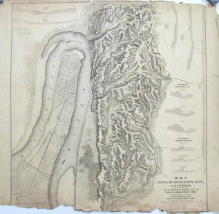
Sold2017Map of the Siege of Vicksburg, MississippiMap: Map of the Siege of Vicksburg, Mississippi Description: This large battle map identifies Union and Confederate entrenchments. It is very detailed, showing the roads, streets, houses, railroads, vSee Sold Price
Sold2020Comparative Map of Cape Cod Harbor Showing PhysicalTitle/Content of Map: Comparative Map of Cape Cod Harbor Showing Physical Changes Publication Date: 1867 Cartographer: GRAHAM, JAMES DUNCAN/BENJAMIN PEIRCE/HENRY L. WHITING Publisher: STATE CAPE COD BSee Sold Price
Sold2023Rare 1925 Map of The Town and Harbor of Nantucket by Phillip L. HallRare 1925 Map of The Town and Harbor of Nantucket by Phillip L. Hall, whimsical map showing the town, harbor, ships, aircraft, and prominent landmarks of the island. Overall 23 in. x 15 in.See Sold Price
Sold2016Map, New York Harbor, G. Mathiot, 1886This map depicts the New York Bay and Harbor area as of 1886, printed with color and with as accurate as possible scaling and measurements of depth given the time period. The top left denotes the yearSee Sold Price
Sold2023[MAP] TACHARD, G. CARTE MARINE [INDIA, ETC.] 1701Tachard Guy. CARTE MARINE Depius Suratte jusqu'au Detroit de Malaca Dressee par le R.P. Tachard de la Compangnie de Jesus... Paris: I.B. Nolin [Jean-Baptiste Nolin], 1701. Map showing India, Ceylon (SSee Sold Price
Sold20201803 Map Plan Harbor of Mahon CandiaEngraved map and Plan showing the Harbor of Mahon and the isle of Candia. Published by Cadell and Davies, London, 1803. Fine, measures 8.25 x 11". Reserve: $20.00 Shipping: Domestic: Flat-rate of $5.0See Sold Price
Sold2021Where not to park in San Francisco BayHeading: (California - San Francisco Bay) Author: Board of State Harbor Commissioners Title: Map showing forbidden anchorage, Bay of San Francisco, Mar. 1910 Place Published: No place Publisher:See Sold Price
Sold2022[MANUSCRIPT MAP-FLORIDA & MISSISSIPPI RIVER] Map Showing Raiford's Proposed Artificial River and[MANUSCRIPT MAP-FLORIDA & MISSISSIPPI RIVER] Map Showing Raiford's Proposed Artificial River and Plan to Continue the Western and Southern Inland System of Navigation to Harbors in the Atlantic. [FernSee Sold Price
Sold2018Map of Charleston Harbor, Showing Fort Sumter and theTitle: Map of Charleston Harbor, Showing Fort Sumter and the Confederate Batteries. Date: 1861-04-27 Cartographer: ANONYMOUS Size: 9.25 X 13.8 Please note that this lot has a confidential reserve. WheSee Sold Price
Sold2017Civil War Era Map of Charleston, SC and EnvironsE & G. W. Blunt's Map of Charleston and Vicinity (New York: E & G. W. Blunt, 1862), a handy map for military purposes showing both land and sea routes in the region. Unframed in a 1950s mailing/storagSee Sold Price
Sold2021Map of proposed S.F. water supply, 1877Heading: (California - San Francisco Water Supply) Author: Title: Map showing sources and lines of water supply proposed for the City of San Francisco, 1877 Place Published: San Francisco Publisher:LSee Sold Price
Sold2019Historical Map of ScotlandTitle: Historical Map of Scotland Publication Date: 1952 Cartographer: BULLOCK, L. G. Publisher: JOHN BARTHOLOMEW & SON Size: 36.5 X 24.25 Vividly colored maps showing historic sites surrounded by armSee Sold Price
Sold2019Cohasset harbor map and chartWAR DEPARTMENT MAP AND CHART OF COHASSET HARBOR. Detailed map of the South Shore from Boston to Cohasset showing harbors and coves including Whitehead, Bailey Creek, Bassing Beach etc.. Framed . DimenSee Sold Price
Sold2016Original Map of Indiana and KentuckyOriginal, early Map showing Indiana and Kentucky in frame. Dimensions: 20" H x 22" WSee Sold Price
Sold20221630 Mercator Map of Catalonia of Spain -- CataloniaTitle: 1630 Mercator Map of Catalonia of Spain -- Catalonia Cartographer: G Mercator Date/Place: 1630, Amsterdam Dimensions: 7.2 X 9.9 in. Description: This is an attractive map showing the province oSee Sold Price
Sold20231832 map showing U.S. expansion westHeading: (United States) Author: Tasso, G. Title: Stati-Uniti dell' America Settentrionale dalle Piu Recenti Mappe... Place Published: Venice Publisher: Date Published: 1832 DescriptionSee Sold Price
Sold2017Hawaiian Islands Map, George Cram, 1906Hawaiian Islands. George Cram. Cram's Unrivaled Family Atlas of the World Indexed. 1906. 14.5 x 12 inches. Inset showing Harbor of Honolulu Please note that this lot has a confidential reserve. When ySee Sold Price
Sold2017Hawaiian Islands Map, George Cram, 1905Hawaiian Islands. George Cram. 1895. Map showing placenames, roads, elevations of mtns. points, bays, etc. Inset: Harbor of Honolulu Island of Oahu. Please note that this lot has a confidential reservSee Sold Price
Sold20191893Crams's Map of New Orleans verso Atlanta -- NewTitle/Content of Map: 1893Crams's Map of New Orleans verso Atlanta -- New Orleans verso Atlanta Date: 1893, New York Cartographer: G Cram Size: 11.3 X 9.4 in. Very nice maps showing streets, steam / hSee Sold Price
Sold20181891 Watson Cram Map of New Orleans, Verso AtlantaTitle/Content of Map: 1891 Watson Cram Map of New Orleans, Verso Atlanta -- New Orleans verso Atlanta1891, Chicago Cartographer: G Cram / Watson & Co Size: 11.3 X 9.4 in. Very nice maps showing streetSee Sold Price
Sold2019U S Coast Survey 1896 LG Map. Gulf Coast. Florida, MI"Sketch Showing Progress of Surveys on the Gulf Coast Lake Pontchartrain Mobile and Pensacola Bays" Detailed map showing New Orleans to Santa Rosa Sound, with inset showing Tortugas Harbor. Large LithSee Sold Price
Sold2019Mexico and Central AmericaTitle/Content of Map: Mexico and Central America Date: 1863 Cartographer: WELL, J./SHERMAN, G.E. Publisher: MCNALLY'S GEOGRAPHY Size: 8.3Height - 10.5Width Map showing southern part of U.S. Arizona isSee Sold Price
Sold2017Robinson / Dilly: Antique Map of Poland, 1785Map: Poland Date Printed: 1785 Cartographer: G. Robinson & C. Dilly Material/Medium: Paper Size: 9 3/4" x 8 1/3" Condition: Excellent Published in London. Showing the changes of Russia, Prussia, & AusSee Sold Price
4 days LeftJasper521902 Cram Map of New York City [verso] Washington DC [verso] Baltimore -- New York [verso]US$60
6 days LeftHolabird Western Americana CollectionsWyoming History (3) 1899 & 1955 Reprints [182275]US$200
BonhamsMajor G. Carmichael Smyth, A History of the Reigning Family of Lahore W. Thacker & Co., Calcutta...£1,200
BonhamsCARADOC PRESS - PRINTED ON VELLUM HOBSON (GEORGE ANDREW, Member of the Institute of Civil Engine...£1,500
BonhamsSTIRRUP (THOMAS) Horometria: Or the Compleat Diallist: Wherein the Whole Mystery of the Art of D...£10
Jun 08Simpson Galleries, LLC.JULIUS BIEN (1826-1909) AN AMERICAN CIVIL WAR RECONNAISSANCE MAP, "Map of Texas and Part of NewUS$100
4 days LeftJasper521893 Civil War Map of Siege of Yorktown, Battle of Siloh and Army of Ohio Operations -- Plan ofUS$55
Jun 08Early American History Auctions1776 Map, PARTIE ORIENTALE DU CANADA, AVEC LA NOUVELLE ANGLETERRE, L'ACADIE... by P. Santini, FramedUS$950
7 days LeftFreeman's | Hindman[MAP]. ORTELIUS, Abraham. Aevi Veteris, Typus Geographicus. 1601.US$150
7 days LeftFreeman's | Hindman[MAP]. SPEED, John. A New Mappe of the Romane Empire. 1676.US$200(1 bid)
Jun 12Dan Morphy AuctionsINDIAN TERRITORY - DEPARTMENT OF THE INTERIOR GENERAL LAND OFFICE, C.1883US$100(1 bid)
7 days LeftFreeman's | Hindman[MAP]. TODESCHI, Pietro. [Nova et Acurata Totius Americae Tabula auct. G.I. Blaeu] America quartaUS$5,000


![[MAP] TACHARD, G. CARTE MARINE [INDIA, ETC.] 1701: Tachard Guy. CARTE MARINE Depius Suratte jusqu'au Detroit de Malaca Dressee par le R.P. Tachard de la Compangnie de Jesus... Paris: I.B. Nolin [Jean-Baptiste Nolin], 1701. Map showing India, Ceylon (S](https://p1.liveauctioneers.com/8124/310027/165853627_1_x.jpg?height=310&quality=70&version=1700184289)


![[MANUSCRIPT MAP-FLORIDA & MISSISSIPPI RIVER] Map Showing Raiford's Proposed Artificial River and: [MANUSCRIPT MAP-FLORIDA & MISSISSIPPI RIVER] Map Showing Raiford's Proposed Artificial River and Plan to Continue the Western and Southern Inland System of Navigation to Harbors in the Atlantic. [Fern](https://p1.liveauctioneers.com/292/250642/130213644_1_x.jpg?height=310&quality=70&version=1654271664)


![1902 Cram Map of New York City [verso] Washington DC [verso] Baltimore -- New York [verso] (1 of 3)](https://p1.liveauctioneers.com/5584/331064/178466310_1_x.jpg?height=282&quality=70&version=1716924723)
![Wyoming History (3) 1899 & 1955 Reprints [182275] (1 of 3)](https://p1.liveauctioneers.com/2699/331494/178785555_1_x.jpg?height=282&quality=70&version=1717094654)


![[First Australian novelist] Grimstone, Mary Leman (1 of 1)](https://p1.liveauctioneers.com/94/330664/178342107_1_x.jpg?height=282&quality=70&version=1716466933)


![[MAP]. ORTELIUS, Abraham. Aevi Veteris, Typus Geographicus. 1601. (1 of 3)](https://p1.liveauctioneers.com/197/329395/177650532_1_x.jpg?height=282&quality=70&version=1715364962)
![[MAP]. SPEED, John. A New Mappe of the Romane Empire. 1676. (1 of 2)](https://p1.liveauctioneers.com/197/329395/177650541_1_x.jpg?height=282&quality=70&version=1715364962)

![[MAP]. TODESCHI, Pietro. [Nova et Acurata Totius Americae Tabula auct. G.I. Blaeu] America quarta (1 of 1)](https://p1.liveauctioneers.com/197/329395/177650542_1_x.jpg?height=282&quality=70&version=1715364962)
![[MAP]. ORTELIUS, Abraham. Romani Imperii Imago. 1592. (1 of 2)](https://p1.liveauctioneers.com/197/329395/177650537_1_x.jpg?height=282&quality=70&version=1715364962)
