Sold20221885 French Map Of The Amazon19th century map of the Amazon by H. A. Coudreau. Dated 1885. 7 1/4 x 19 7/8 inches (sheet size). Four fold creases, as produced, otherwise very good condition.See Sold Price
Sold2020FRENCH DEPARTMENT MAPS, STEEL ENGRAVINGS PAIRFRENCH DEPARTMENT MAPS, STEEL ENGRAVINGS PAIR, 12" X 17" Maps of various provences of France. Published by A. Combette. Circa 1885. Each framed, 23" x 27".See Sold Price
Sold2021Jack & Bartholomew 1885 Mixed Lot of 21 MapsIncl Aral Sea, Cape Colony, French Ports, Alps, Algiers, Central Africa, Azores, Bristol Channel, Brazil, Borneo, Faroe Islands, Egypt, Dutch Guyana, Dublin, Fiji/Cyprus, Crimea, Belfast/Cork, ConstanSee Sold Price
Sold201718th C. French Map w/ Oiled Paper, ex-Sotheby'sEurope, France, map from 1709 CE, oiled paper overlays from 1756 to 1763 CE, owned by Louis-Alexandre Berthier (1753 to 1815 CE), Marshal, Vice-Constable of France, and Chief of Staff (Major general)See Sold Price
Sold2021Antique French Map of MississippiAntique French Map of Mississippi , "Carte Geographique, Statistique et Historique du Mississipi", Paris, Buchon, 1825, sight 21 in. x 27 1/2 in., framed Provenance: Estate of Julia Evans ReedSee Sold Price
Sold2015CIRCA 1885 FRENCH PAIR OF FIGURAL NEW POST LIGHTSCIRCA 1885 FRENCH PAIR OF FIGURAL NEW POST LIGHTS BRONZED SPELTER, PATINATED AND GUILD WITH AUTHENTIC ORIGINAL LEFT AND RIGHT FACING MAIDENS IN CLASSICAL REVIVAL STYLE - 42 INCHES HIGH - MARKET VALUESee Sold Price
Sold2021Antique French Map of United States- Etats-Unis De L'Amerique Septentrionale Avec Les Isles Royale, De Terre Neuve, De St. Jean, L'Acadie &c.; Hand-colored; Ches Boudet Imprimeur du Roi; Paris; undated (circa 1785). One of the early maSee Sold Price
Sold2018Rodolphe Bresdin (1822 - 1885 French)Moulin a eau [Water Mill], 1886 Etching on chine-colle under glass Initialed in the plate lower left: RB, indistinctly inscribed in the plate lower left and lower right, titled in another hand verso,See Sold Price
Sold2022Mannevillette French Map of the Indian Ocean, 1753D'APRES DE MANNEVILLETTE, Jean-Baptiste-Nicolas-Denis (1707-1780). [Indian Ocean] Carte Reduite de l'Ocean Oriental depuis le Cap de Bonne Esperance... Engraved map with original hand color in part. PSee Sold Price
Sold20241812 large French map of Paris plan routier de la Ville et faubourgLarge engraving of Paris and its surrounding area dated 1812 , cooper engraving in the manner of the Turgot map ,Jean Pierre printer , a Paris, chez Jean, Rue St Jean de Beauvais, N° 10, It is thSee Sold Price
Sold20221738 Antique French Map of North America1738 Antique French Map of North America, 1783 - Antique Map of North America, with documentation, This map is 221 years old - it is not a modern reproduction or copy, This map comes from: ATLAS DE TOSee Sold Price
Sold201718th Century French Map of North AmericaL’Amerique Septentrionale. Daniel de la Feuille (1640-1709). Engraved map with hand color in full. Amsterdam, 1702 or 1706. 6 x 8 inches visible, 13 x 14 1/2 inches framed. Nicely colored early 18thSee Sold Price
Sold2022c. 1788 French Map of the Eastern United StatesHistoric Maps c. 1788 Map, "Les Etats Unis de L'Amerique Septentrionale, Partie Orientale" (Eastern Part of the Northern United States of America) by M. (Rigobert) Bonne c. 1788 Map titled, "Les EtatsSee Sold Price
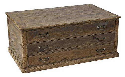
Sold2020Country French Map CabinetThree drawer case in pine with original brass hardware. Drawers pull out from both sides. 49w x 31 1/2d x 20 1/2hSee Sold Price
Sold2023Guillaume De L'Isle Philippe Buache Large Antique French Map of the AmericasImportant map of Guillaume de L'Isle corrected by Philippe Buache and edited by Dezauche in 1800 ,after the conclusion of the American revolutionary war and the treaty of Paris Dezauche updated the neSee Sold Price
Sold20211736 large French map of Paris and surrounding areaLarge engraving of Paris and its surrounding area dated 1736 , cooper engraving in the manner of the Turgot map , name of printer not lisible ,the date is clear . H.23 1/4 x W. 36 , suitable for framiSee Sold Price
Sold202118th C. French Map "Le Noveau Mexique …"Ribobert Bonne (French, 1727-1794). "Le Nouveau Mexique, Avec La Partie Septentrionale De L'Ancien, ou De La Nouvelle Espagne" Published in Paris, 1780. Among the most collected late 18th century mapsSee Sold Price
Sold2021French Map of the World Decorative ArtsFrench Map of the World, piece appears to be hand drawn and colored, inscriptions to piece in French, label to reverse reads ‘Le Normand, Charles 14 x 19 Manuscript World Map’, subject a map of thSee Sold Price
Sold202118TH CENTURY FRENCH MAP OF SOUTHEASTERN USRigobert Bonne (French, 1727-1794). "Carte De la Partie Sud Des Etats Unis De L'Amerique Septentrionale" -circa 1780, engraving. Provenance: From the Lifetime Collection of Billy S. Arant, Jr., ChattaSee Sold Price
Sold2022FRENCH MAP "AFRIQUE" Circa 1720 Color engraving, 8" x 9" sight. Framed 15.5" x 16.5".FRENCH MAP "AFRIQUE"Circa 1720Color engraving, 8" x 9" sight. Framed 15.5" x 16.5".See Sold Price
Sold2018AN 1659 FRENCH MAP OF DENMARK BY NICOLAS SANSONA hand-colored map of Northern Denmark by Nicolas Sanson (1600-1667), signed Sanson and dated with a cartouche on the lower left. Sheet measures 16.25 x 21 inches. Frame measures 20.5 x 26.5 inches. WSee Sold Price
Sold2018Framed 18th C. French Map of Ancient Rome**First Time At Auction** Louis Brion de la Tour (French, 1743-1810) & Louis Charles Desnos (French, 1725-1805), "Suite De L'Histoire De Rome", ca. 1760 to 1770. Copperplate engraved with original hanSee Sold Price
Sold2016French map of U.S. derived from MelishHeading: Author: Buchon, Jean Alexandre Title: Etats-Unis d'Amerique Place Published: Paris Publisher: Date Published: 1825 Description: Copper-engraved map, hand-colored.See Sold Price
7 days LeftThomaston Place Auction GalleriesHAND COLORED MAP OF PERU & COUNTRY OF THE AMAZONS, 1747, BY EMANUEL BOWEN, FRAMEDUS$250
8 mins LeftJasper52Balkans 1878 Treaty of Berlin. Bulgaria Eastern Roumelia Turkey GRAPHIC 1885 mapUS$55
8 hrs LeftOriental Art AuctionsA RARE NON COLORED PRINTED FRENCH MAP OF THE ARABIC WORLD DURING THE OTTOMAN EMPIRE (ARABIA€1,000
8 mins LeftJasper52Operation Dragoon 15 August 1944. Assault. Invasion of South of France 1961 mapUS$30
8 mins LeftJasper52WORLD WAR 2. Siegfried & Maginot line defences. Pre-invasion of France 1940 mapUS$30


![Rodolphe Bresdin (1822 - 1885 French): Moulin a eau [Water Mill], 1886 Etching on chine-colle under glass Initialed in the plate lower left: RB, indistinctly inscribed in the plate lower left and lower right, titled in another hand verso,](https://p1.liveauctioneers.com/255/119809/61041866_1_x.jpg?height=310&quality=70&version=1522368721)
![Mannevillette French Map of the Indian Ocean, 1753: D'APRES DE MANNEVILLETTE, Jean-Baptiste-Nicolas-Denis (1707-1780). [Indian Ocean] Carte Reduite de l'Ocean Oriental depuis le Cap de Bonne Esperance... Engraved map with original hand color in part. P](https://p1.liveauctioneers.com/1968/250616/130196497_1_x.jpg?height=310&quality=70&version=1654190895)