Sold20211886 World Hemispherical MapTitle: 1886 World Hemispherical Map Author: Blackie Medium: Ink on Paper Dimensions: 21"X15" Description: World hemispherical map dated 1886. Part of the Imperial Atlas of Modern Geography. This was tSee Sold Price
Sold20181886 Rand McNally World Map -- Map of the WorldTitle/Content of Map: 1886 Rand McNally World Map -- Map of the World Date: 1886, Chicago Cartographer: Rand McNally Size: 12.8 x 19.5 in. Very nice world map, offering details on topography and settlSee Sold Price
Sold20201886 Map of ItalyAuthor: Watson Title: 1886 Map of Italy Medium: Ink on Paper/Glass/Wood Dimensions: 17"X20" Map of Italy from Watson's Illustrated Atlas of the World dated 1886. Published by Iliff&co. in Chicago. MapSee Sold Price
Sold2021Fascinating Lakes & Islands comparison, 1886Title: Fascinating Lakes & Islands comparison, 1886 Description: Highly unusual and visually pleasing comparative map of the world’s lakes and islands. This pictorial map came from the very scarce CSee Sold Price
Sold20201886 Map of LondonAuthor: Cram Title: 1886 Map of London Medium: Ink on Paper Dimensions: 21.5"X14.5" Map of London dated 1886. Engraved and published by George Cram in Chicago. Part of his World Atlas. Double folio maSee Sold Price
Sold20201886 Map of BostonAuthor: Watson Title: 1886 Map of Boston Medium: Ink on Paper Dimensions: 10.5"X14.5" Map of Boston dated 1886. Part of the Standard Atlas of the World published by Watson in Chicago. Map key locatedSee Sold Price
Sold20211886 Map of MontanaAuthor: Cram Title: 1886 Map of Montana Medium: Ink on Paper Dimensions: 21"X13.5" Map of Montana dated 1886. Printed and published by George Cram in Chicago. Part of his World Atlas. Key lower left.See Sold Price
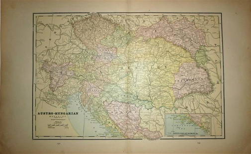
Sold2024Austro-Hungarian Empire 1886Title/Content of Map: Austro-Hungarian Empire 1886 Date Printed: 1886 Material/Medium: paper Size: 13x 21 inches Additional Info: The People's Family Atlas of the World Reserve: $45.00 Shipping: DomesSee Sold Price
Sold2018Cram: Antique Map of Tallest Mountains, Longest RiversTitle/Content of Map: 1886 Cram Map of Tallest Mountains and Longest Rivers -- Principal Mountains of the World and Principal Rivers of the World Date Printed: 1886, Chicago Cartographer: G Cram Size:See Sold Price
Sold2020Oceanica 1886Title/Content of Map: Oceanica 1886 Date Printed: 1886 Material/Medium: Paper Size: approx. 10x 13 inches Additional Info: The People's Family Atlas of the World. Publ. by W.H. Stewart, Rochester, NYSee Sold Price
Sold2020Territorial Growth of the US 1886Title/Content of Map: Territorial Growth of the US 1886 Date Printed: 1886 Material/Medium: Paper Size: approx. 10x13 inches Additional Info: The People's Unrivaled Family Atlas of the World Reserve:See Sold Price
Sold20211886 Map of AfricaAuthor: Watson Title: 1886 Map of Africa Materials: Ink on Paper Size/Dimensions: 14.5"X22.5" Description: Map of Africa dated 1886. Printed and published by Watson in Chicago. Part of his World AtlasSee Sold Price
Sold2020Bird's-Eye-View of the Holy Land 1886Title/Content of Map: Bird's-Eye-View of the Holy Land 1886 Date Printed: 1886 Material/Medium: paper Size: approx. 14x11 inches The People's Family Atlas of the World. Publ. by W.H. Stewart, RochesteSee Sold Price
Sold2020New Hampshire 1886Title/Content of Map: New Hampshire 1886 Date Printed: 1886 Material/Medium: paper Size: 13.5x21 inches Additional Info: he People's Unrivaled Family Atlas of the World. People's Publishing Co, ChicagSee Sold Price
Sold2020California 1886Title/Content of Map: California 1886 Date Printed: 1896 Material/Medium: paper Size: approx. 21.5x13.5 inches Additional Info: The People's Unrivaled Family Atlas of the World. People's Publishing CoSee Sold Price
Sold2020Spain & Portugal 1886Title/Content of Map: Spain & Portugal 1886 Date Printed: 1886 Material/Medium: paper Size: approx. 19x13 inches Additional Info: The People's Unrivaled Family Atlas of the World. People's PublishingSee Sold Price
Sold2020Austro -Hungarian Monarchy 1886Title/Content of Map: Austro -Hungarian Monarchy 1886 Date Printed: 1886 Material/Medium: paper Size: Approx. 13.5x21 inches The People's Unrivaled Family Atlas of the World. People's Publishing Co, CSee Sold Price
Sold20211886 Arizona MapAuthor: Watson Title: 1886 Arizona Map Medium: Ink on Paper Dimensions: 11"X14.5" Map of Arizona dated 1886. Engraved and published by Watson in Chicago. Part of his World Atlas. Key lower left. WithSee Sold Price
Sold2021Africa 1886Title/Content of Map: Africa 1886 Date Printed: 1886 Material/Medium: paper Size: 13x 21.5 inches The People's Family Atlas of the World Reserve: $30.00 Shipping: Domestic: Flat-rate of $15.00 to anySee Sold Price
Sold2020Michigan, Wisconsin 1886Title/Content of Map: Michigan, Wisconsin 1886 Date Printed: 1886 Material/Medium: paper Size: approx 13.5x21 inches Additional Info: The People's Unrivaled Family Atlas of the World. People's PublishSee Sold Price
Sold2020Greece 1886Title/Content of Map: Greece 1886 Date Printed: 1886 Material/Medium: Paper Size: approx. 21x13.5 inches The People's Unrivaled Family Atlas of the World. Reserve: $30.00 Shipping: Domestic: Flat-ratSee Sold Price
Sold20211886 Map of ScotlandAuthor: Cram Title: 1886 Map of Scotland Medium: Ink on Paper Dimensions: 11"X14.5" Map of Scotland dated 1886. Engraved and published by George Cram in Chicago. Part of his World Atlas. Key lower lefSee Sold Price
Sold20211886 Map of SacramentoAuthor: Cram Title: 1886 Map of Sacramento Medium: Ink on Paper Dimensions: 14.5"X11" Map of Sacramento dated 1886. Engraved and published by George Cram in Chicago. Part of his World Atlas. Key locatSee Sold Price
Sold20201886 Map of BermudaAuthor: Watson Title: 1886 Map of Bermuda Medium: Ink on Paper Dimensions: 14.5"X11.5" Map of Bermuda dated 1886. Part of Watson's Standard Atlas of the World. Published in Chicago. Key upper middle.See Sold Price
Sep 29South Jersey Auction by Babington Auction IncLrg. world map decorated trunk style coffee tableUS$100
5 days LeftJasper52Antique Felix Delamarche Vaugondy Mappemonde Double hemisphere world map 1838US$95
4 days LeftJasper521894 Rand McNally Map of British Columbia -- Indexed Atlas of the World Map of British ColumbiaUS$35
4 days LeftJasper52Rand, McNally & Co.'S Indexed Atlas of the World Map of Germany (Western Sheet). | (Eastern Sheet).US$60
4 days LeftJasper52Austria-Hungary Rand, McNally & Co.'S Indexed Atlas of the World Map of Austria-Hungary.US$70
4 days LeftJasper521788 Gravius World Map -- Kaart van de Geheele Wereld na de Alderlaatste OntdekkingenUS$130
15 hrs LeftFine Arts OutletYoung Couple Reviewing a World Map Bronze Statue - Size: 32"L x 47"W x 42"H.US$3,150
5 days LeftForum AuctionsWorld.- Blaeu (Johannes) Nova et Accuratissima Totius Terrarum Orbis Tabula Auctore Joanne Blaeu,£7,000
6 days LeftAlex CooperNicolas Visscher. "Orbis Terrarum Tabula Recens Emendata et in Lucem Edita Per N. Visscher,"US$400