Sold20231891 Mitchell Map of Maryland, Virginia, North Carolina and South Carolina -- Map of Maryland,Title: 1891 Mitchell Map of Maryland, Virginia, North Carolina and South Carolina -- Map of Maryland, Virginia, North Carolina and South Carolina Cartographer: S Mitchell Year/Place: 1891, PhiladelphiSee Sold Price
Sold2016Map of Maryland, Virginia, North & South CarolinaTitle: Map of Maryland, Virginia, North Carolina and South Carolina Maker: S. Augustus Mitchell Date: 1878 No Reserve: This lot starts at $1 and has no reserve as a courtesy so that collectors can detSee Sold Price
Sold20201869 Mitchell Map of Maryland, Virginia, West VirginiaTitle/Content of Map: 1869 Mitchell Map of Maryland, Virginia, West Virginia and North Carolina -- XI Maryland, Virginia, West Virginia and North Carolina Cartographer: S Mithchell Year/Place: 1869, PSee Sold Price
Sold2019Eight (8) Augustus Mitchell MapsCollection of eight maps including New Jersey/Maryland Delaware 1872, Two north and South Carolina 1872 maps (15" x 12"), Minnesota 1890 , Florida and the Carolinas 1860, County map of the state of ArSee Sold Price
Sold2016Large 1862 US Civil War Wall MapColton's Map of the Southern States. Including Maryland, Delaware, Virginia, Kentucky, Tennessee, Missouri, North Carolina, South Carolina, Georgia, Alabama, Mississippi, Arkansas, Louisiana, Texas ..See Sold Price
Sold2023Map of Maryland, Virginia Texas +Map of South Carolina, Georgia, Florida, Alabama, Mississippi, Louisiana, Tennessee and Arkansas PLUS Maryland, Virginia, West Virginia & North Carolina [1 half sheet side] & Texas [1 half sheet side]See Sold Price
Sold2022A MAP OF VIRGINIA, NORTH AND SOUTH CAROLINA, GEORGIA, MARYLAND, WITH PART OF NEW JERSEY, & C, 1755.A MAP OF VIRGINIA, NORTH AND SOUTH CAROLINA, GEORGIA, MARYLAND, WITH PART OF NEW JERSEY, & C, 1755. - 9 x 11 in; frame: 12.5 x 14.5 in.See Sold Price
Sold2022Early 1847 school atlas map of East Coast statesEarly map of Maryland, Virginia, North Carolina and Delaware from Smith’s Quarto Geography published 1848 by Cady & Burgess. Very few railroad lines shown, as the industry was still in its infanSee Sold Price
Sold2017Map of Delaware Maryland Virginia North Carolina, 1860Map of Delaware, Maryland, Virginia, North Carolina. Smith's Geography Atlas. 1860. 9.5 x 11.5 inches. Before West Virginia Split Off Please note that this lot has a confidential reserve. When you leaSee Sold Price
Sold20231755 Robert De Vaugondy Map of North America Large1755 Robert De Vaugondy Map of America. Mid-Atlantic, New York, New Jersey, Pennsylvania Virginia, Maryland, New England, Carolina and Ohio. Partie De L'Amerique Septentrionale. Map in matte is aboutSee Sold Price
Sold20181867 Mitchell Map of North and South Carolina -- CountyTitle/Content of Map: 1867 Mitchell Map of North and South Carolina -- County Map of North and South Carolina Date: 1867, Philadelphia Cartographer: S Mitchell Size: 11.5 x 13.8 in. This is a handsomeSee Sold Price
Sold2022United Virginia, north & South Carolina, Maryland, 1859, by ColtonTitle: United Virginia, north & South Carolina, Maryland, 1859, by Colton Date/Period: 1859 Materials: Hand colored lithographic printing Size: 15 x 12 inches Shows a pre civil war United Virginia, alSee Sold Price
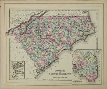
Sold20221877 Mitchell Map of North and South Carolina -- North and South CarolinaTitle: 1877 Mitchell Map of North and South Carolina -- North and South Carolina Cartographer: S Mitchell Date/Place: 1877 Philadelphia Dimensions: 10.5 x 13.5 in. Description: This is an excellent anSee Sold Price
Sold20211887 Mitchell Map of North and South Carolina -- NorthTitle: 1887 Mitchell Map of North and South Carolina -- North and South Carolina Cartographer: S Mitchell Year / Place: 1887, Philadelphia Map Dimension (in.): 11.3 X 14 in. A very nice map of the CarSee Sold Price
Sold20211884 Mitchell Map of North and South Carolina -- NorthTitle: 1884 Mitchell Map of North and South Carolina -- North and South Carolina Cartographer: S Mitchell Year / Place: 1884, Philadelphia Map Dimension (in.): 11.3 X 14 in. This is a very nice map ofSee Sold Price
Sold20181876 Mitchell Map of North and South Carolina -- NorthReserve Reduced! Title/Content of Map: 1876 Mitchell Map of North and South Carolina -- North and South Carolina Date: 1876 Philadelphia Cartographer: S Mitchell Size: 10.5 x 13.5 in. Excellent and hiSee Sold Price
Sold2021Map of Part of Virginia, North Carolina, South CarolinaPublication Date: c1865Title: Map of Part of Virginia, North Carolina, South Carolina & Georgia Cartographer: KEMBLE, W. Publisher: VIRTUE, EMMINS & CO. Height: 9 Width: 5.5 "which were the scenes ofSee Sold Price
Sold20231860 Mitchell Map of Florida, South and North Carolina -- County Map of Florida on page with Map ofTitle: 1860 Mitchell Map of Florida, South and North Carolina -- County Map of Florida on page with Map of South Carolina, on page with County Map of North Carolina Cartographer: S Mitchell Year / PlaSee Sold Price
Sold20201860 Mitchell Map of Florida, South and North CarolinaTitle/Content of Map: 1860 Mitchell Map of Florida, South and North Carolina -- County Map of Florida on page with Map of South Carolina, on page with County Map of North Carolina Cartographer: S MitcSee Sold Price
Sold20211860 Mitchell Map of Florida, South and North CarolinaTitle: 1860 Mitchell Map of Florida, South and North Carolina -- County Map of Florida on page with Map of South Carolina, on page with County Map of North Carolina Cartographer: S Mitchell Year / PlaSee Sold Price
Sold20181863 Mitchell Map of Florida, South and North CarolinaTitle/Content of Map: 1863 Mitchell Map of Florida, South and North Carolina -- County Map of Florida on page with Map of South Carolina, on page with County Map of North Carolina Date: 1863, PhiladelSee Sold Price
Sold20181860 Mitchell Map of Florida, South and North CarolinaTitle/Content of Map: 1860 Mitchell Map of Florida, South and North Carolina -- County Map of Florida on page with Map of South Carolina, on page with County Map of North Carolina Date Printed: 1860,See Sold Price
Sold20201860 Mitchell Map of Florida, South and North CarolinaTitle/Content of Map: 1860 Mitchell Map of Florida, South and North Carolina -- County Map of Florida on page with Map of South Carolina, on page with County Map of North Carolina Date: 1860, PhiladelSee Sold Price
Sold201918th c. Purcell Map, "State of Franklin"Joseph Purcell: A MAP OF THE STATES OF VIRGINIA, NORTH CAROLINA, SOUTH CAROLINA, AND GEORGIA; Comprehending the SPANISH PROVINCES of EAST AND WEST FLORIDA. Scarce Edinburgh, Scotland imprint, circa 17See Sold Price
7 days LeftJasper521878 Mitchell Map of Virginia and West Virginia [verso] New Jersey, Maryland and Delaware -- CountyUS$45
May 24Meander Auctions by Andrew Richmond and Hollie DavisSERIES OF 10 SOLDIER STUDIES BY DON TROIANI (AMERICAN, B. 1949)US$150
4 days LeftBlackstone Valley Auctions & Estates LLCRevolutionary Era War Map of the Attack on Ft. Moultrie.US$275(3 bids)
7 days LeftFreeman's | HindmanGio Ponti (Italian, 1891-1979) Pair of Leggera Hardwood Side Chairs, designed 1952Cassina, ItalyUS$650(3 bids)
12 hrs LeftUniversity ArchivesScarce Early Printing: "An Account of the European Settlement in America in 6 Parts..."US$100
2 days LeftFreeman's | HindmanGuy Arthur Wiggins (American, 1920-2020) The East River from the South Street SeaportUS$2,500
2 days LeftPotter & Potter AuctionsLANGENECKERT. It’s A Dog’s World. 1968. St. Louis: Ralston ...US$100


![Map of Maryland, Virginia Texas +: Map of South Carolina, Georgia, Florida, Alabama, Mississippi, Louisiana, Tennessee and Arkansas PLUS Maryland, Virginia, West Virginia & North Carolina [1 half sheet side] & Texas [1 half sheet side]](https://p1.liveauctioneers.com/5614/289638/153375966_1_x.jpg?height=310&quality=70&version=1684353133)


![1878 Mitchell Map of Virginia and West Virginia [verso] New Jersey, Maryland and Delaware -- County (1 of 2)](https://p1.liveauctioneers.com/5584/329422/177662152_1_x.jpg?height=282&quality=70&version=1715717898)


