Sold2017Pocket Map of Long Beach & Southern California, 19271927 Pocket Map of Long Beach and Southern California. 9 x 12.75 and 8.5 x 12.5 inches. Two-sided pocket map shows Long Beach on one side and a Motor Map of Southern California on the other. PublishedSee Sold Price
Sold2020Rare street map of Hollywood, Cal.Heading: (California - Hollywood) Author: Title: Security-First National Map of Hollywood and Vicinity and Motor Map of Southern California Place Published: Los Angeles Publisher: Date PublishedSee Sold Price
Sold2020Street map of Monrovia in LA CountyHeading: (California - Monrovia) Author: Title: Security-First National Map of Monrovia and Vicinity and Motor Map of California Place Published: Los Angeles Publisher: Date Published: 1930<See Sold Price
Sold2017VINTAGE MAPS AND MOREVINTAGE MAPS - UTAH OIL REFINING COMPANY - WESTERN STATES - SHELL - MAP OF NEVADA/UTAH AND ARIZONA/NEW MEXICO - RPM MOTOR OIL MAP - CALIFORNIA POINTS OF INTEREST AND TOURING MAP - AND MANY MORE - ALLSee Sold Price
Sold2018Bacons Motor Road Map c.1930s: Scotland. On ClothTitle/Content of Map:Bacons Motor Road Map c.1930s: Scotland. On Cloth Date: c.1920s Cartographer: Material/Medium: Folded in boards color map reinforced with original gauze. Size: folder 7.5x4.5x0.5See Sold Price
Sold20222 SEASIDE ADVERTISMENTSSST MOTOR OIL RACK SIGN & PAPER MAP OF CALIFORNIA. SURFACE SCRATCHES, FOLDED CORNERS ON MAP. 15" x 16"See Sold Price
Sold2021Southern California Transportation Ephemera (5)Lot of 5. All related to Southern California, specifically Los Angeles and Orange Counties. Collection consists of Pacific Electric Railway train schedules and route map from 1942 and a AAA map of OraSee Sold Price
Sold2015VTG MAPS & SO.PAC TIME TABLES, ETCVARIOUS VINTAGE EPHEMERA - NOVEMBER 1955 ORIGIN OF PLAYA STONE TRACKS, RACETRACK PLAYA, INYO COUNTY, CALIFORNIA - 1980 SOUTHERN PACIFIC WESTERN DIVISION TIMETABLE 16 - 5 SOUTHERN PACIFIC TIME TABLES -See Sold Price
Sold2023Vintage Souvenir Map of Worlds Fair Sponsor General MotorsGeneral Motors, Highways and Horizons World Fair list of displays, things to see and map. Issued: 1940 Dimensions: 5"L x 7.75"H Country of Origin: United StatesSee Sold Price
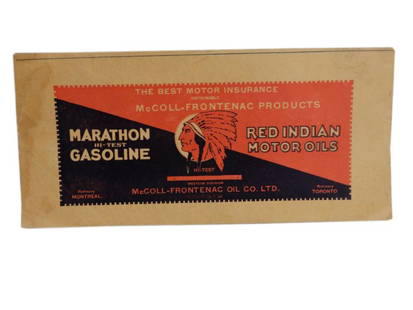
Sold20201933 McCOLL-FRONTENAC SASKATCHEWAN ROAD MAP MAP &1933 McCOLL-FRONTENAC SASKATCHEWAN ROAD MAP MAP & ADVERTISING, SOME STAINING & WEAR, EXCELLENT COVER ADVERTISING RED INDIAN GASOLINE & MOTOR OIL, 11" X 5.25"See Sold Price
Sold2024Carte De La Californie Suivant (early Group of 5 California maps) 1772 [171215]A spectacular set of 5 maps showing California history from 1604 to 1767. Measures 15x12[x=#8221/]. 1) Earliest map (upper right) is based upon a manuscript map by Mathieu Neron Pecci drawn in FlorencSee Sold Price
Sold2020Pictorial Map Southern CaliforniaRadio Comedians Map of Southern California. Radio Stations of Los Angeles and Orange County areas. 2nd Quarter, 20th Century. 11 1/2" x 18".See Sold Price
Sold20211930s Southern California Map -- Road Map SouthernTitle: 1930s Southern California Map -- Road Map Southern section of California Cartographer: Automobile Club of Southern California Year / Place: mid 1930s, Los Angeles Map Dimension (in.): 16.8 X 31See Sold Price
Sold20211920's maps from the Automobile Club of SoCalHeading: (California) Author: Title: Collection of Early 20th century Automobile Club of Southern California maps Place Published: Los Angeles Publisher:Automobile Club of Southern California DaSee Sold Price
Sold20211885 California MapAuthor: Cram Title: 1885 California Map Medium: Ink on Paper Dimensions: 13.5"X21.5" Map of California dated 1885. Printed and published by George Cram in Chicago. Part of his World Atlas. Double foliSee Sold Price
Sold20201892 Map of CaliforniaAuthor: Cram Title: 1892 Map of California Medium: Ink on Paper Dimensions: 14.5"X21.5" Map of California dated 1892. Engraved and published by George Cram in Chicago. Double folio map. Mint conditionSee Sold Price
Sold20211888 Map of CaliforniaAuthor: Cram Title: 1888 Map of California Medium: Ink on Paper Dimensions: 13.5"X21.5" Map of California dated 1888. Printed and published by George Cram in Chicago. Part of his World Atlas. Key loweSee Sold Price
Sold20201884 Map of CaliforniaAuthor: Cram Title: 1884 Map of California Medium: Ink on Paper Dimensions: 13.5"X21.5" Map of California dated 1884. Printed and published by George Cram in Chicago. Part of The People's Family WorldSee Sold Price
Sold20201885 Map of CaliforniaAuthor: Watson Title: 1885 Map of California Medium: Ink on Paper Dimensions: 13.5"X21.5" Map of California dated 1885. Engraved and published by Watson in Chicago. Part of his World Atlas. Double folSee Sold Price
Sold2020Road map of Southern California 1918Heading: (California) Author: Title: Automobile Road Map of Los Angeles, Orange, Riverside and San Bernardino Counties Place Published: Los Angeles Publisher:Security Trust & Savings Bank Date PSee Sold Price
Sold2023Pictorial bird's-eye map of Southern CaliforniaHeading: (California - Southern) Author: Putnam, Claude George, Sr. Title: Ride the Roads to Romance Along the Golden Coast and Thru the Sunshine Empire of Southern California Place Published: No placSee Sold Price
Sold2017Automobile road map of southern California 1928Heading: (California - Los Angeles) Author: Clason Map Co. Title: Security Trust & Savings Bank Automobile Road Map of the Los Angeles Region Place Published: Los Angeles Publisher: Date PublisheSee Sold Price
Sold2017Pictorial map of Southern CaliforniaHeading: (California) Author: Putnam, Claude G. Title: Southern California's Sunshine Empire and Golden Coast (wrapper title) Place Published: San Bernardino, CA Publisher:Southern California TouristSee Sold Price
Sold20201963 Putnam Pictorial Map of Southern California --Title/Content of Map: 1963 Putnam Pictorial Map of Southern California -- Ride the Roads to Romance along the Gold Coast thru the Sunshine Empire of Southern California Cartographer: C Putnam Year/PlaSee Sold Price
Jul 11Dan Morphy AuctionsRARE INDEPENDENT GASOLINE & MOTOR OIL FRAMED GRAPHIC HIGHWAY MAP OF ILLINOIS.US$125
3 days LeftJasper52SOUTH AMERICA. 'La Plata, Chili, Paraguay, Uruguay & Patagonia'. LOWRY 1862 mapUS$35
3 days LeftJasper52ARGENTINA PARAGUAY URUGUAY CHILE BRAZIL. Shows battles/dates.La Plata 1903 mapUS$8
3 days LeftJasper52SOUTHERN CENTRAL AMERICA. Mosquito New Granada Venezuela. ETTLING 1863 old mapUS$35
Jun 23Schilb Antiquarian Rare Books1848 Emory Military Reconnaissance 1ed California MAP Indians Texas New MexicoUS$2(2 bids)
Jun 08Early American History Auctionsc 1730 Hand-Colored Colonial Era Map of the Americas, California shown as an Island, Matted + FramedUS$500(1 bid)
3 days LeftJasper52Spanish North America, southern part by John Thomson. Central America 1817 mapUS$85
Jun 12Dan Morphy AuctionsBRUE'S MONUMENTAL WALL MAP OF TEXAS, UPPER CALIFORNIA & MEXICO, C. 1845US$500
Featured3 days LeftJasper52Americae Australis / Peruana by Bertius / Langenes. South America 1603 old mapUS$280
3 days LeftJasper52SOUTHERN MEXICO & CENTRAL AMERICA. Lighthouses. Key West Yucatan. LETTS 1884 mapUS$15
3 days LeftJasper52SOUTHERN MEXICO & CENTRAL AMERICA. Yucatan Belize Mosquito Coast. SDUK 1846 mapUS$25
3 days LeftJasper52Amér Mér Colombie & Brésil 9 Peru Colombia Amazonas Brazil VANDERMAELEN 1827 mapUS$70
3 days LeftJasper52SOUTH AMERICA SOUTH SHEET. Shows Bolivia claim on Gran Chaco. JOHNSTON 1912 mapUS$8
Featured3 days LeftJasper52SOUTH AMERICA SOUTH SHEET. Shows Bolivia claim on Gran Chaco. JOHNSTON 1913 mapUS$8
3 days LeftJasper52SOUTHERN MEXICO & CENTRAL AMERICA. Lighthouses. Key West Yucatan. LETTS 1883 mapUS$15
3 days LeftJasper52Carte du Paraguay et des Pays voisins'. Uruguay Brazil. BELLIN/SCHLEY 1772 mapUS$70


![Carte De La Californie Suivant (early Group of 5 California maps) 1772 [171215]: A spectacular set of 5 maps showing California history from 1604 to 1767. Measures 15x12[x=#8221/]. 1) Earliest map (upper right) is based upon a manuscript map by Mathieu Neron Pecci drawn in Florenc](https://p1.liveauctioneers.com/2699/324080/174413209_1_x.jpg?height=310&quality=70&version=1711485545)


