Sold20191938 R Taylor White Pictorial Map of Maine -- MaineTitle/Content of Map: 1938 R Taylor White Pictorial Map of Maine -- Maine Date: 1938, Boston Cartographer: Ruth Taylor White Size: 11.6 x 8.5 in. This is Ruth Taylor White's charming pictorial map, orSee Sold Price
Sold20181938 R Taylor White Pictorial Map of CaliforniaTitle/Content of Map: 1938 R Taylor White Pictorial Map of California -- California Date Printed: 1938, Boston Cartographer: Ruth Taylor White Size: 11.6 x 8.5 in. This is Ruth Taylor White's charmingSee Sold Price
Sold20181938 R Taylor White Pictorial Map of Florida -- FloridaTitle/Content of Map: 1938 R Taylor White Pictorial Map of Florida -- Florida Date: 1938, Boston Cartographer: Ruth Taylor White Size: 11.6 x 8.5 in. This is Ruth Taylor White's charming pictorial mapSee Sold Price
Sold20201938 R Taylor White Pictorial Map of Hawaii and SamoaTitle: 1938 R Taylor White Pictorial Map of Hawaii and Samoa -- Territory of Hawaii [with] Samoa Cartographer: Ruth Taylor White Year/Place: 1938, Boston Size: 11.6 x 8.5 in. Description: This is RuthSee Sold Price
Sold20181938 R Taylor White Pictorial Map of Hawaii and SamoaTitle/Content of Map: 1938 R Taylor White Pictorial Map of Hawaii and Samoa -- Territory of Hawaii [with] Samoa Date Printed: 1938, Boston Cartographer: Ruth Taylor White Size: 11.6 x 8.5 in. This isSee Sold Price
Sold20231938 R Taylor White Pictorial Map of Hawaii and Samoa -- Territory of Hawaii [with] SamoaTitle: 1938 R Taylor White Pictorial Map of Hawaii and Samoa -- Territory of Hawaii [with] Samoa Cartographer: Ruth Taylor White Year / Place: 1938, Boston Map Dimension (in.): 11.6 x 8.5 in. This isSee Sold Price
Sold20221938 R Taylor White Pictorial Map of Texas -- TexasTitle: 1938 R Taylor White Pictorial Map of Texas -- Texas Cartographer: Ruth Taylor White Year / Place: 1938, Boston Map Dimension (in.): 11.6 x 8.5 in. This is Ruth Taylor White's charming pictorialSee Sold Price
Sold20211938 R Taylor White Pictorial Map of Texas -- TexasTitle: 1938 R Taylor White Pictorial Map of Texas -- Texas Cartographer: Ruth Taylor White Year / Place: 1938, Boston Map Dimension (in.): 11.6 x 8.5 in. This is Ruth Taylor White's charming pictorialSee Sold Price
Sold20211938 R Taylor White Pictorial Map of the PhilippineTitle: 1938 R Taylor White Pictorial Map of the Philippine Islands -- Philippine Islands Cartographer: Ruth Taylor White Year / Place: 1938, Boston Map Dimension (in.): 11.6 x 8.5 in. This is Ruth TaySee Sold Price
Sold20181938 R Taylor White Pictorial Map of Colorado --Title/Content of Map: 1938 R Taylor White Pictorial Map of Colorado -- Colorado1938, Boston Cartographer: Ruth Taylor White Size: 8.5 11.6 in. This is Ruth Taylor White's charming pictorial map, or caSee Sold Price
Sold20181938 R Taylor White Pictorial Map of the PhilippineTitle/Content of Map: 1938 R Taylor White Pictorial Map of the Philippine Islands -- Philippine Islands Date Printed: 1938, Boston Cartographer: Ruth Taylor White Size: 11.6 x 8.5 in. This is Ruth TaySee Sold Price
Sold20181938 R Taylor White Pictorial Map of Kansas -- KansasTitle/Content of Map: 1938 R Taylor White Pictorial Map of Kansas -- Kansas Date: 1938, Boston Cartographer: Ruth Taylor White Size: 11.6 x 8.5 in. This is Ruth Taylor White's charming pictorial map,See Sold Price
Sold20181938 R Taylor White Pictorial Map of the Caribbean andTitle/Content of Map: 1938 R Taylor White Pictorial Map of the Caribbean and Central America -- This Map locates the Panama Canal Zone, Porto Rico and Virgin Islands in Central America and the West InSee Sold Price
Sold20201938 R Taylor White Pictorial Map of New Jersey -- NewTitle/Content of Map: 1938 R Taylor White Pictorial Map of New Jersey -- New Jersey Cartographer: Ruth Taylor White Year/Place: 1938, Boston Size: 11.6 x 8.5 in. This is Ruth Taylor White's charming pSee Sold Price
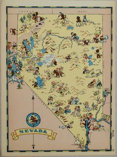
Sold20211938 R Taylor White Pictorial Map of Nevada -- NevadaTitle: 1938 R Taylor White Pictorial Map of Nevada -- Nevada Cartographer: Ruth Taylor White Year / Place: 1938, Boston Map Dimension (in.): 11.6 x 8.5 in. This is Ruth Taylor White's charming pictoriSee Sold Price
Sold20201938 R Taylor White Pictorial Map of Utah -- UtahTitle/Content of Map: 1938 R Taylor White Pictorial Map of Utah -- Utah Date: 1938, Boston Cartographer: Ruth Taylor White Size: 11.6 x 8.5 in. This is Ruth Taylor White's charming pictorial map, or cSee Sold Price
Sold20211938 R Taylor White Pictorial Map of Massachusetts --Title: 1938 R Taylor White Pictorial Map of Massachusetts -- Massachusetts Cartographer: Ruth Taylor White Year / Place: 1938, Boston Map Dimension (in.): 11.6 x 8.5 in. This is Ruth Taylor White's chSee Sold Price
Sold20201938 R Taylor White Pictorial Map of North Carolina --Title: 1938 R Taylor White Pictorial Map of North Carolina -- North Carolina Date: 1938, Boston Cartographer: Ruth Taylor White Size: 11.6 x 8.5 in. Additional Information: This is Ruth Taylor White'sSee Sold Price
Sold20201938 R Taylor White Pictorial Map of Georgia -- GeorgiaTitle/Content of Map: 1938 R Taylor White Pictorial Map of Georgia -- Georgia Cartographer: Ruth Taylor White Year/Place: 1938, Boston Size: 11.6 x 8.5 in. This is Ruth Taylor White's charming pictoriSee Sold Price
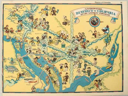
Sold20211938 R Taylor White Pictorial Map of Washington D.C. --Title: 1938 R Taylor White Pictorial Map of Washington D.C. -- Washington District of Columbia the National Capital Cartographer: Ruth Taylor White Year / Place: 1938, Boston Map Dimension (in.): 11.6See Sold Price
Sold20211938 R Taylor White Pictorial Map of the United StatesTitle: 1938 R Taylor White Pictorial Map of the United States -- The United States of America Cartographer: Ruth Taylor White Year / Place: 1938, Boston Map Dimension (in.): 11.6 x 8.5 in. This is RutSee Sold Price
Sold20191938 R Taylor White Pictorial Map of Michigan --Title/Content of Map: 1938 R Taylor White Pictorial Map of Michigan -- Michigan Date: 1938, Boston Cartographer: Ruth Taylor White Size: 11.6 x 8.5 in. This is Ruth Taylor White's charming pictorial mSee Sold Price
Sold20211938 R Taylor White Pictorial Map of Missouri --Title: 1938 R Taylor White Pictorial Map of Missouri -- Missouri Cartographer: Ruth Taylor White Year / Place: 1938, Boston Map Dimension (in.): 11.6 x 8.5 in. This is Ruth Taylor White's charming picSee Sold Price
Sold20211938 R Taylor White Pictorial Map of Kentucky --Title: 1938 R Taylor White Pictorial Map of Kentucky -- Kentucky Cartographer: Ruth Taylor White Year / Place: 1938, Boston Map Dimension (in.): 11.6 x 8.5 in. This is Ruth Taylor White's charming picSee Sold Price
14 hrs LeftPotter & Potter AuctionsBATE, Neel (1916 – 1989). Jimmy and Sally in Mother Goose L...US$200
14 hrs LeftPotter & Potter AuctionsHANDY, R.D. (1879 – 1959). Paul Bunyan’s Pictorial Map of t...US$200(1 bid)
14 hrs LeftPotter & Potter AuctionsLANGENECKERT. It’s A Dog’s World. 1968. St. Louis: Ralston ...US$100
May 24Kinghams AuctioneersMaritime Interest, Cunard White Star Limited, R.M.S. Franconia, a 1938 Log Book, Northern and£40(1 bid)
15 hrs LeftZikorn Arts & History ObjectsThe Soldier in Our Civil War a Pictorial History 1861- 65, 2 VolsUS$200
Jun 29JM Hobby Supply and Railroad Artifact AuctionsMaine Central RR Peter Gray Train Order LampUS$100
May 24Eldred'sRUDOLPH COLAO (Massachusetts/Maine, 1927-2014), Floral still life., Oil on canvas, 30" x 24". FramedUS$200
13 hrs LeftEldred'sCLEMENT ROLLINS GRANT (Massachusetts/Maine, 1848-1893), Interior scene with a young woman windingUS$150
May 24Eldred'sRAYMOND A. EWING (Massachusetts/Maine, 1891-1976), "Burnt Cove Deer Isle, Me.", Oil on masonite, 24"US$275(2 bids)
May 23Luxe Auctioneers, IncPATEK PHILIPPE OBSERVATORY GRADE 21 JEWEL EXTRA GRADE WITH GUILLAUME BALANCE POCKET WATCH, CIRCAUS$3,000
1818 AuctioneersPolar Travel. North-West Passage. Two titles: The Search for Franklin. A Narrative of the American£18(1 bid)
14 hrs LeftPotter & Potter AuctionsPictorial Map of Hollywood and Vicinity / Hollywood Film Ca...US$125(1 bid)
14 hrs LeftPotter & Potter AuctionsWalt Disney World EPCOT Center. 1982. Color pictorial map o...US$125
14 hrs LeftPotter & Potter AuctionsCrosby Service Pictorial Map of Manhattan (New York City). ...US$250
14 hrs LeftPotter & Potter Auctions[NEW YORK CITY – PICTORIAL MAPS]. Group of 3 pictorial maps...US$200(1 bid)
14 hrs LeftPotter & Potter AuctionsDisneyland. 1968. Walt Disney Productions. This 1968 versio...US$125
14 hrs LeftPotter & Potter AuctionsLINDGREN, Jolly (1895-1952). A Hysterical Map of Yellowstone Park and the Jackson Hole CountryUS$125
14 hrs LeftPotter & Potter AuctionsSTORM, Mark. Official Texas Brags Map of North America. 194...US$200(1 bid)
14 hrs LeftPotter & Potter AuctionsRCA Victor Radio, Amusement and Educational Map of the Worl...US$100
14 hrs LeftPotter & Potter AuctionsBOLLMANN, Hermann (1911 – 1971). Map of New York City. 1962.US$100


![1938 R Taylor White Pictorial Map of Hawaii and Samoa: Title: 1938 R Taylor White Pictorial Map of Hawaii and Samoa -- Territory of Hawaii [with] Samoa Cartographer: Ruth Taylor White Year/Place: 1938, Boston Size: 11.6 x 8.5 in. Description: This is Ruth](https://p1.liveauctioneers.com/5584/169916/85621317_1_x.jpg?height=310&quality=70&version=1591137604)
![1938 R Taylor White Pictorial Map of Hawaii and Samoa: Title/Content of Map: 1938 R Taylor White Pictorial Map of Hawaii and Samoa -- Territory of Hawaii [with] Samoa Date Printed: 1938, Boston Cartographer: Ruth Taylor White Size: 11.6 x 8.5 in. This is](https://p1.liveauctioneers.com/5584/117342/60336911_1_x.jpg?height=310&quality=70&version=1520389291)
![1938 R Taylor White Pictorial Map of Hawaii and Samoa -- Territory of Hawaii [with] Samoa: Title: 1938 R Taylor White Pictorial Map of Hawaii and Samoa -- Territory of Hawaii [with] Samoa Cartographer: Ruth Taylor White Year / Place: 1938, Boston Map Dimension (in.): 11.6 x 8.5 in. This is](https://p1.liveauctioneers.com/5584/274166/143946169_1_x.jpg?height=310&quality=70&version=1673389176)


![[NEW YORK CITY – PICTORIAL MAPS]. Group of 3 pictorial maps... (1 of 3)](https://p1.liveauctioneers.com/928/325952/175495562_1_x.jpg?height=282&quality=70&version=1712935174)


