Sold20221942 Official Road Map of WisconsinPublication Date: 1942 Title: 1942 Official Road Map of Wisconsin Cartographer: GOUSHA, H. M. COMPANY Publisher: SKELLY OIL COMPANY Height: 26 Width: 19.25 Double sided road map with Wisconsin city plSee Sold Price
Sold2016Depression Era Southwest MemorabiliaDepression Era Southwest Memorabilia, includes Santa Fe Fred Harvey Dining Car Service Meal Check, Roy Rogers Dale Evens New Museum Brochure, 1942 Official Road Map of New Mexico, 1935 Official New MeSee Sold Price
Sold2020Official Road Map to Disneyland Richfield Guide 1956Rare 1956 Official Road Map to Disneyland Guide. This is a really hard to find brochure.See Sold Price
Sold2023Official Road Map of FloridaPublication Date: 1936 Title: Official Road Map of Florida Cartographer: Mid West Map Co. Publisher: Mid West Mao Co. Height: 20 Width: 16 Front panel imprinted in red, "Compliments of New American HoSee Sold Price
Sold2018Logansport Foundry Industries, Inc. Logansport, Ind.Title: Logansport Foundry Industries, Inc. Logansport, Ind. U.S.A. Official Road Map of the United States Publication Date: c1940 Cartographer: GOUSHA COMPANY Publisher: THE H. M. GOUSHA COMPANY Size:See Sold Price
Sold2018Automobile Road Map of WisconsinTitle: Automobile Road Map of Wisconsin Publication Date: 1937 Cartographer: W.W. HIXSON & CO. Publisher: W.W. HIXSON & CO. Size: 25.5X20.8 Map showing counties, towns, rivers & creeks and shows all hSee Sold Price
Sold2022Collection of (7) Disneyland Brochures.(Disneyland, 1955-61) A collection of (7) Disneyland brochures. These early Park artifacts include a 1955 complimentary "Official Disneyland Road Map," a 1955 informative guide offering main routes anSee Sold Price
Sold2017Cram's Rail Road & Township Map of Wisconsin. 1876[Midwest] Pocket map: CRAM’S RAIL ROAD & TOWNSHIP MAP OF WISCONSIN. Chicago: Geo. F. Cram, 1876. 20 ¾ x 16 in., full hand coloring, original pictorial wrappers. Lower horizontal fold partly split,See Sold Price
Sold20223-1937 Cities Service Road Maps Georgia, Missouri & Wisconsinrated 7, 9"x4.5", all have light soiling.See Sold Price
Sold2022Vintage Railroad CollectiblesClason's 1919 Wisconsin Road Map & Railway Guide. This is a rare and hard to find Clason's 1919 Wisconsin Road Map and Railway Guide. It lists all of the cities and towns in Wisconsin, along with theiSee Sold Price
Sold20211916 Official Large WI Railroad MapThis 1916 official Railroad map of Wisconsin is paper with a canvas backing on a scale of 1 inch=10 square miles. It has come lose in some spots from its wood top bar, and has a little loss to the uppSee Sold Price
Sold2015Official map of the county of San Mateo, California,Official map of the county of San Mateo, California, showing the new boundary line and delineating the lines of cities, towns, private claims, ranchos, water works and rail roads Official Map of the CSee Sold Price
Sold20221940 & 1942 Union Oil Company Road Maps California, Nevadarated 8, 9"x5", both have good color, light wear.See Sold Price
Sold20161959 Official MINNESOTA State Highway Roadmap FoldoutVintage 1959 Official MINNESOTA State Highway Roadmap Map. A nice foldout map that measures 9-1/2" x 4" when folded. Paper is crisp with no writing or staining. Overall excellent+ condition.See Sold Price
Sold2024GROUP OF 6 RARE 1930'S CANADIAN ROAD MAPSGroup of 6 1930's Canadian Highway and Tourist Road Maps. Including 1930 Quebec, 1933 Nova Scotia, 1936 / 1937 Ontario Official Government, 1939 Quebec To Crown Your World's Fair Trip, 1939 Nova ScotiSee Sold Price
Sold20221942 & 1945 Union Oil Co., Golden Gate Exposition Road Mapsrated 7 to 8, 9"x5", or less in size, have light wear and soiling.See Sold Price
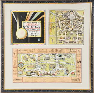
Sold2022Framed Tony Sarg 1939 World's Fair Pictorial MapTony Sarg (American, 1880-1942), "The New York 1939 Official World's Fair Pictorial Map Created by Tony Sarg 25¢" cover and Transportation Zone maps, three pieces matted and under glass in paintedSee Sold Price
Sold2022Vintage map of Wisconsin & Michigan, 1865Johnson and Ward’s dynamic layout showing both of these Great Lakes states. The map includes parts of four of the five Great Lakes. Railroads, roads, coastal features, rivers, lakes, mines, IndiSee Sold Price
Sold2022(KENTUCKY.) J.T. Lloyd. Lloyd's Official Map of the State of Kentucky.(KENTUCKY.) J.T. Lloyd. Lloyd's Official Map of the State of Kentucky. Compiled from Actual Surveys and Official Documents, Showing Every Rail Road & Rail Road Station with the Distances Between EachSee Sold Price
Sold2020New/Old Stock Garden Signs from William L. Spoon EstateTitle: New/Old Stock Garden Signs from William L. Spoon Estate Provenance/Additional Info: William L. Spoon (1862 - 1942), Alamance Co., NC was a map maker, surveyor & supervisor of public roads. ThisSee Sold Price
Sold2024Pair of American Aviation Official Airline Guides - October 1957 and March 1965A pair of Official Airline Guides North American Edition published by American Aviation with airline schedules, fares and information. October 1957 guide with over 650 pages and fold out map, shows moSee Sold Price
Sold2024Three American Aviation Publications - 1953 and 1956 Official Airline Guides and 1948 Air TrafficThree publications from American Aviation including January 1948 Air Traffic Guide with 244 pages and fold out map of United States and Foreign Airline Schedules, Fares and Information, showing mild dSee Sold Price
8 hrs LeftArader GalleriesAsher & Adams First Edition of New Topographical Map of the State of New YorkUS$800
Oct 12JM Hobby Supply and Railroad Artifact AuctionsKenyons Pocket Map and Shippers Guide of Wisconsin-1914US$40
5 days LeftJasper52London Greenwich Chatham Sittingbourne Canterbury Dover OGILBY road map #28 1675US$300
Oct 05Mega International AuctionMEI LANFANG PEONY THREE OFFICIAL MAP VERTICAL AXIS FINE MOUNTEDUS$750
5 days LeftJasper52A Topographical plan of Manchester & Salford 92x105cm LAURENT/STOCKDALE 1793 mapUS$480
5 days LeftJasper52Horwood London D4 Kennington Elephant & Castle Kennington Park Road 1799 mapUS$460
5 days LeftJasper52Horwood London A2 Marylebone Mayfair Hyde Park Bayswater Edgware Road 1794 mapUS$500
1 day LeftSimpson Galleries, LLC.WILLIAM JAMES STONE (1800-1865) A REPUBLIC OF TEXAS OFFICIAL U.S. BOUNDARY MAP, "Map of the riverUS$300
5 days LeftJasper52Chart of the Mediterranean Sea. Marseilles Genoa Gibraltar. THOMSON 1817 mapUS$260
Oct 12JM Hobby Supply and Railroad Artifact AuctionsBlacks Road and Railway Travelling Map of Scotland ca 1865US$30


![Cram's Rail Road & Township Map of Wisconsin. 1876: [Midwest] Pocket map: CRAM’S RAIL ROAD & TOWNSHIP MAP OF WISCONSIN. Chicago: Geo. F. Cram, 1876. 20 ¾ x 16 in., full hand coloring, original pictorial wrappers. Lower horizontal fold partly split,](https://p1.liveauctioneers.com/179/104231/53361918_1_x.jpg?height=310&quality=70&version=1495213319)