Sold2023Four Washington D.C. Related Maps & Prints ca. 19th CenturyGroup of four Washington D.C. related maps & prints, ca. mid to late 19th century. Frame size of "Map of Washington. District of Columbia." are 10 1/2" H x 11 1/2" W x 3/8" D.See Sold Price
Sold2022Framed 1873 Columbia County MapFramed page from Columbia County Atlas, 1873, showing Malden Bridge, East Chatham, Chatham, Chatham Center, New Concord, and Claverack, 13 3/4" x 16 1/2" framed.See Sold Price
Sold2017District of Columbia US Territories Quarters(12) Mint sealed $25 bags, 2009. Including: (2) American Samoa D and P, (2) N. Marina Islands, D and P, (2) US Virgin Islands Dand P, (2) District of Columbia D and P, (2) Puerto Rico D and P, (2) GuaSee Sold Price
Sold2017Various CoinsIncludes: 1831 Morgan Dollar, 1885 Morgan Dollar, 1921 Morgan dollar, 2 2009 District of Columbia proof sets, a Vatican commemorative medallion and a 1997 Inaugural medal.See Sold Price
Sold20222009-2013 US MINT QUARTER PROOF SETS - LOT OF 82009-2013 US MINT QUARTER PROOF SETS - LOT OF 8 Lot of eight United States mint quarter proof set coins, to include: (2) 2009 District of Columbia & U.S. territories quarter proof sets (3)See Sold Price
Sold2015Rare Bolton 1873 Pocket Map of Copper DistrictFull title being: Portion of the Copper District Michigan Lake Superior 1873. Published by Geo. D. Bolton, Calumet, Mich. This fine and rare hand colored pocket map is on polished paper and is 20 x 29See Sold Price
Sold20164 maps: Colonial US, Maryland, DC, Railroads[Railroads/MD/DC] 4 Maps. ++ J.G. Langdon. MAP OF THE DISTRICT OF COLUMBIA 1901… FOR THE PREPARATION OF A PLAN FOR THE IMPROVEMENT OF THE PARK SYSTEM OF THE DISTRICT OF COLUMBIA. NO. D-99. Balt: A.See Sold Price
Sold2021Vintage D. of C. Tokens2-Rolls Vintage District of Columbia CAPITAL TRANSIT TOKEN - One Fare District of ColumbiaSee Sold Price
Sold20213 Antique Columbia County Colored Maps 1873, Hudson NYAntique Lot of Three Columbia County Colored Maps 1873. Maps for Stockport/Stuyvesant Landing, Hudson, and Greenport with plastic covers and cardboard backs. Pink, blue, and yellow colors with detaileSee Sold Price
Sold20156 TRANSPORTATION TOKENS SEE DESCRIPTION SEATTLESEATTLE TRANSIT, W.M. & A MOTOR LINES DISTRICT OF COLUMBIA, 2-MIAMI TRANSIT, INDIANAPOLIS RAILWAYS AND PORTSMOUTH TRANSIT COMPANYSee Sold Price
Sold2023Charles Lanman (NY,DC,MI,1819-1895) oil painting antiqueARTIST: Charles F Lanman (New York, Washington, District Of Columbia, Michigan, 1819 - 1895) TITLE: Coastal Seascape MEDIUM: oil on paper CONDITION: Overall good. Framed under the glass. No visible inSee Sold Price
Sold2022Grouping of United States Silver Coins2 United States Mint 2009 District of Columbia and U.S. Territories quarter silver proof sets, plus one 1993 United States Mint premiere silver proof set. Overall good condition, each in original caseSee Sold Price
Sold2017Civil Defense Fallout Forecast Map c.1960.Civil Defense Fallout Forecast Map c.1960. This large, vintage Fallout Forecast map was issued by the District of Columbia Office of Civil Defense. This map contained vital planning information for AmSee Sold Price
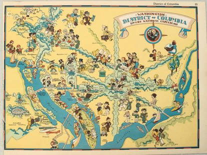
Sold20211938 R Taylor White Pictorial Map of Washington D.C. --Title: 1938 R Taylor White Pictorial Map of Washington D.C. -- Washington District of Columbia the National Capital Cartographer: Ruth Taylor White Year / Place: 1938, Boston Map Dimension (in.): 11.6See Sold Price
Sold2017Levasseur: Map of Corsica, 1854Map: Dept. de la Corse Cartographer: V. Levasseur Place & Date: Paris / 1854 Size: 11 1/2" x 16 3/4" Condition: map in wash color surrounded by b&w vignettes The superbly detailed and decorative CorsiSee Sold Price
Sold20221849 & 1850 GW Boynton Boston Almanac Maps(1) Map of the Vicinity of Boston / Engraved for the Boston Almanac / 1849. Losses right margin, foxing and toning spots, signs of age, etc. Folds as issued 10.25" x 11.25" approx. (2) Map of New EnglSee Sold Price
Sold2021Mid Century Printed Linens / Tablecloths(1) Damask woven tablecloth with Art Deco blue border. Appears in excellent condition. 51" x 51". (2) Map of California tablecloth. Some small stains, toning, etc. 50" x 50' approx. (3) Blue Art DecoSee Sold Price
Sold2024John Cary 1819 Map of North AmericaJohn Cary 1819 Map of North America. 'A New Map of North America from the Latest Authorities' by John Cary, Engraver 1819. Overall Size: 25 x 26 1/2 in. Sight Size: 18 1/2 x 21 in. #1430See Sold Price
Sold2017Visscher: Antique Map of Beloved Land of Canaan, 1650Map: Het Beloofde Landt Canaan Cartographer: N. Visscher Place & Date: Amsterdam / 1650 Size: 18 1/2" x 12 1/4" Condition: outline color (map), wash color (cartouche and vignettes); overall age toningSee Sold Price
Sold2018District of ColumbiaTitle/Content of Map: District of Columbia Date: 1835 Cartographer: T.G. Bradford Size: 9.75X7.6 Page 37 from T.G. Bradford’s A comprehensive atlas geographical, historical & commercial. 1835.See Sold Price
Sold2016Misc 1930's Era AdvertisingMisc 1930's Era advertising including: (9) Life Buoy wash up charts, Gas Station maps including: (2) Esso war map roman numeral II, (2) Sunoco war maps, (3) Air Craft Identification booksSee Sold Price
Sold20191861 & 1855 Maps of Boston(1) 1861 map by W. C. Sharp, Boston. Advertising to reverse. Fold crease separations, some with tape repairs. 10 1/2" x 11 1/4" approx. (2) 1855 map engraved by G. W. Boynton. Very good condition; ageSee Sold Price
Sold2023Howard Chesner Behrens (1933-2014) Oil ( District of Columbia, Ill)Oil on canvas. Beach towels signed lower left. Housed in gilt frame. Signed to verso. Wally Findlay Gallery. Sight 39 1/2 x 49 1/2, frame 45 1/2 x 55 1/2.See Sold Price
Sold20242 VOLUMES, FOLIO, THE COMPLETE ATLAS OF MODERN CLASSICAL, AND CELESTIAL MAPS, 1873The Complete Atlas of Modern Classical and Celestial Maps, in two Volumes. London: Edward Stanford. 1873. Folio. For display and reference in your library. Condition as shown. Group: 17.75" x 14.5" xSee Sold Price
BonhamsLONDON MAITLAND (WILLIAM) The History of London from its Foundation to the Present Time, J. Wil...£600
BonhamsDANIELL (WILLIAM) A Voyage Round Great Britain, Undertaken in the Summer of the Year 1813, and C...£900
Jun 14Crescent City Auction GalleryAfter Marie Adrien Persac (French/Louisiana, 1823-1873), "Plantations on the Mississippi River fromUS$325
Jun 06Freeman's | HindmanMELVILLE, Herbert (1819-1891). Typee: A Peep at Polynesian Life. During a Four Months' Residence inUS$200
12 hrs LeftNY Elizabeth 1792 OLD INDIA HISTORY ANTIQUE ILLUSTRATED WITH MAPS OF THE EIGHTEENTH CENTURY IN FRENCHUS$50


![4 maps: Colonial US, Maryland, DC, Railroads: [Railroads/MD/DC] 4 Maps. ++ J.G. Langdon. MAP OF THE DISTRICT OF COLUMBIA 1901… FOR THE PREPARATION OF A PLAN FOR THE IMPROVEMENT OF THE PARK SYSTEM OF THE DISTRICT OF COLUMBIA. NO. D-99. Balt: A.](https://p1.liveauctioneers.com/179/85723/44107986_1_x.jpg?height=310&quality=70&version=1457208384)