Sold2017Bonne: Antique Map of World on Mercator's ProjectionTitle/Content of Map: 'Planisphere suivant la Projection de Mercator' A map of the world on Mercator's projection, showing the trade winds Date Printed: 1780 Image Size: Approx 23.0 x 35.0cm, 9 x 13.7See Sold Price
2017Bonne: Antique Map of World on Mercator's ProjectionTitle/Content of Map: 'Planisphere suivant la Projection de Mercator' A map of the world on Mercator's projection, showing the trade winds Date Printed: 1780 Image Size: Approx 23.0 x 35.0cm, 9 x 13.7See Sold Price
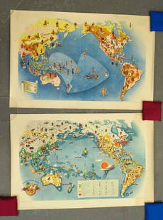
Sold2022(2) LUCIEN BOUCHER , ORIGINAL PICTORIAL MAPLUCIEN BOUCHER (1889-1971) (2) ORIGINAL AIR FRANCE COLOR LITHOGRAPH PLANISPHERE PICTORIAL TRAVEL MAPS OF THE WORLD FOR AIRLINE DESTINATIONS OF AIR FRANCE , TITLED "NOVA ET VETERA" , Sur La Vieille TerSee Sold Price
Sold2021(5pc) HOFFMANN-LA ROCHE MAPS1950s reissues of four 17th century maps, by Hoffmann - La Roche Inc, Nutley, N.J., including [1] Series M1 Overton London 1670 (13-3/4 x 17-1/4 in.); [2] Series M4 Mercator Amsterdam c. 1610 (14 x 18See Sold Price
Sold20162 Texas Maps inc. Greenleaf, Tallis1st item: Jeremiah Greenleaf, "Texas Compiled from the Latest and Best Authorities," from a rare 1848 reissue of Greenleaf’s 1842 Universal Atlas. Greenleaf's 1842 map of Texas was based upon Burr��See Sold Price
Sold20222 Antique Maps: Planisphere/ Paris/ Andrivean/ 1865 & Nord-America/ Weiland/ Weimar/ 1834, 21"2 Antique Maps: Planisphere/ Paris/ Andrivean/ 1865 & Nord-America/ Weiland/ Weimar/ 1834, 21"See Sold Price
Sold20163 TN and KY maps inc. Finley and 2 GreenleafThree (3) Maps, 1 of Tennessee, 2 of Kentucky and Tennessee. 1st item: "Tennessee" map engraved by Young and Delleker, published by Anthony Finley, Philadelphia, 1824. From "A New General Atlas, ComprSee Sold Price
Sold20202 Maps of Sardinia and Corsica Mercator and HondiGroup of two maps of Sardinia and Corsica. Gerardus Mercator (1512–1594) and Jodocus Hondius (1563–1612), a hand colored map of Sardinia and Corsica, Amsterdam, 1607. From Atlas Minor GeSee Sold Price
Sold2024Framed Map AssortmentFramed Map Assortment (8) items with (3) maps by Willem Blaeu (Dutch, 1571-1638) including c.1660 'Tirolensis', 'Gastinois et Hurepois' and 'Hannoniae et Namurci', (2) maps by Robert de Vaugondy (FrenSee Sold Price
Sold2021Map LotLot (2) maps mounted on cardboard "The Supplement to / NORTH AMERICA" and "The Continent and Islands of AMERICA…", each 21" x 47 1/2".See Sold Price
Sold2022John Webber, Plates to Cook's VoyagesJohn Webber (English, 1752-1793). Plates to Cook's Voyages. 63 engravings and 2 maps. Each plate approximately: 10.25 in. high x 16 in. wide. Provenance: Collection of the Warde Family, Hooton PagnellSee Sold Price
Sold20241757 George Shelvocke "A Voyage Around the World by the Way of the Great South Sea"2nd revised edition Performed in a private expedition during the war, which broke out with spain in the year 1718 with 2 maps and illustrationSee Sold Price
Sold2021Covarrubias Pacific Asia Pictorial Maps (2)Maps of the Pacific, Golden Gate International Exposition. NY, 1942. Miguel Covarrubias (1904-1957). 2 Maps: Peoples and Economy. Australia, Hawaii, Asia, Americas. .See Sold Price
Sold20182 MAPS FRAMED, SCOTLAND OF OLD, IRELAND, BULLOCK MAPSTwo framed maps, Scotland of Old and Ireland. Windowbox style frames. 1969 Bullock Pictorial Historical Map of Ireland - This is a delightful 1969 L.G. Bullock pictorial historical map of Ireland. BulSee Sold Price
Sold2017Map LotLot (2) maps including Ireland (G.W. Bacon & Co. sight 8 1/2" x 12"), and "BAVARIA-HESSE/US ZONE/WURTEMBERG BADEN" (sight 23" x 20").See Sold Price
Sold2023(2) MAP AND ANGEL CHILDREN WALLPAPERCOLLIERS WORLD MAP IN ROLL 1950S AND DARK BLUE WALLPAPER WITH FLYING ANGELS AT LEAST 50"L X 37"W Terms: Please Read Carefully before Bidding. Hartzell’s Auction Gallery Inc. will Conduct an ON-LINESee Sold Price
Sold2023RARE: Hand Quilled & Draw Railroad Deeds Maps (2) Parts H 17 1/2 x L 25 x D 6’ inches. 225Parts H 17 1/2 x L 25 x D 6’ inches. 225 Pages These pages are all Hand Drawn , quilled & Colored listing the property owners as the train would make its journey going accross country. Each pagSee Sold Price
Sold2022Hand-Colored MapsHand-Colored Maps (2) items including a posthumous printing of John Speed 'A New Mappe of the Romane Empire' including original invoice from George Ritzlin Maps & Prints, depicting the areas encompassSee Sold Price
Sold20232 Travel Maps of US: Atwood Pocket Map 1851 & Williams Framed, 18541st item: PHELPS'S NATIONAL MAP OF THE UNITED STATES, TRAVELLERS GUIDE. EMBRACING THE PRINCIPAL RAIL ROADS, CANALS, STEAM BOAT & STAGE ROUTES THROUGHOUT THE UNION, by J. M. Atwood, published by ThayerSee Sold Price
Sold20222 Southern Maps: Kentucky, 1800 and Southern U.S. 17971st item: THE STATE OF KENTUCKY WITH THE ADJOINING TERRITORIES FROM THE BEST AUTHORITIES 1800, engraved by John Scoles for "New Encyclopaedia" by John Payne, published by John Low, New York, 1800. CopSee Sold Price
Sold20232 FRAMED MAPS, 1723 SO. AMERICA & THE ROMAN ROADS OF BRITIAN (24 1/2" X 20")2 FRAMED MAPS, 1723 SO. AMERICA & THE ROMAN ROADS OF BRITIAN (24 1/2" X 20")See Sold Price
Sold20222 Antique Maps of Saltzberg & Swiss AlpsTwo 18th century hand-colored engraved maps. Includes one titled "Saltzberg" by Gabriel Bodenehr and another titled "La Descente du Cote du Midi des Alpes" (The Descent on the South Side of the Alps)See Sold Price
Featured8 hrs LeftJasper521699 Moll World Map with Cowley's Voyages -- Nouvelle Carte du Monde Suivant l'idee de Mercator ouUS$240
BonhamsBEWICK (THOMAS AND JOHN) History of British Birds, 2 vol. (inc. 2 supplements), 1797-1804-1821; ...£700
7 hrs LeftJasper521630 MAP OF LEDEN BELGIUM LIEGE copper engraving ANTIQUE Mercator-Hondius AtlasUS$50
5 days LeftCarlsen Gallery, Inc.SET OF 14 KLISMOS DINING CHAIRS, PHILA. C.1820 DEXEL FAMILY PROV. INC. 2 SIDE CHAIRS (ARM: 34" X 22"US$500(1 bid)
5 days LeftCarlsen Gallery, Inc.5 BAYONETTE INC. 2 CIVIL WAR, 2 INDIAN WAR & 1 SPAN AM WAR, 2 W/ SCABBARDSUS$150(2 bids)
5 days LeftCarlsen Gallery, Inc.LARKIN GOLDSMITH MEAD MARBLE BUST "VENEZIA" NEO CLASSICAL (1835 - 1910) 25 1/2" TALL INC. SOCLE 15US$2,000
5 days LeftCarlsen Gallery, Inc.3 FRAMED CIVIL WAR DOCUMENTS INC. PROMOTION CERT. & 2 HONORABLE DISCHARGES (LARGEST 12" X 17 1/2" )US$50
5 days LeftCarlsen Gallery, Inc.COMMERAW'S CORLEAR'S HOOK, NY INCISED 1 GAL JUG RIM CHIPS ON BASE (11 3/4" X 7" )US$7,500
5 days LeftCarlsen Gallery, Inc.CIVIL WAR CALVARY TROOPER FULL FIELD GEAR SHELL JACKET, REGULATION ISSUE SCHUYLEKILL ARSENALUS$2,500(8 bids)
5 days LeftCarlsen Gallery, Inc.5 GAL. EAGLE DECORATED POUGHKEEPSIE, NY STONEWARE CROCK REIDINGER & CAIRE , HAIRLINE (12" X 12 1/2"US$300(3 bids)
5 days LeftCarlsen Gallery, Inc.BACCARAT CRYSTAL ZENITH 36 LIGHT CHANDELIER 67" X 51"US$7,000(4 bids)


![(5pc) HOFFMANN-LA ROCHE MAPS: 1950s reissues of four 17th century maps, by Hoffmann - La Roche Inc, Nutley, N.J., including [1] Series M1 Overton London 1670 (13-3/4 x 17-1/4 in.); [2] Series M4 Mercator Amsterdam c. 1610 (14 x 18](https://p1.liveauctioneers.com/522/224670/116072950_1_x.jpg?height=310&quality=70&version=1635972170)