Sold20185V DECORATIVE ANTIQUE LITERATURE Victorian Gilt Twain5V DECORATIVE ANTIQUE LITERATURE Victorian Gilt Twain Sketches Pulp Beadles Dime Dialogues Drama Burlesque Farce Acting Humor McFingal Epic Poem Poetry Trumbull Illustrated Color Map Persepolis AncienSee Sold Price
Sold20186V Collectible History DECORATIVE ANTIQUE AMERICAN6V Collectible History DECORATIVE ANTIQUE AMERICAN HISTORY Victorian Gilt Decorative Endpapers Large Color Folding Map Worlds Columbian Exhibition Geology Democratic Party Wood Engravings IllustratedSee Sold Price
Sold2021Beers & Co 1873 Atlas Columbia County, NY w/ Color Maps1873 Atlas of Columbia County New York, with engravings by Worley & Brocher. First edition hardcover folio with debossed covers and gilt title. Atlas pages have amazingly detailed and colorful hisSee Sold Price
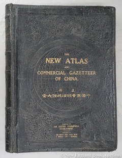
Sold2023Dingle, Edwin John51. Dingle, Edwin John. The New Atlas and Commercial Gazetteer of China. 28 color-printed maps and 18 color-printed statistical tables. Large folio, publisher's black cloth decorated in gilt and blindSee Sold Price
Sold2023L'Africa. DE ROSSI / SANSON 1677 old antique vintage map plan chartTITLE/CONTENT OF MAP: L'Africa [Africa] DATE PRINTED: 1677 IMAGE SIZE: Approx 42.5 x 57.0cm, 16.75 x 22.25 inches (Large) TYPE: Antique 17th century folio atlas map CONDITION: Good; suitable for framiSee Sold Price
Sold2024L'Irlanda o'vero Hibernia. Ireland. DE ROSSI 1689 old antique map plan chartTITLE/CONTENT OF MAP: L'Irlanda o'vero Hibernia [Ireland, or Hibernia] DATE PRINTED: 1689 IMAGE SIZE: Approx 59.0 x 45.0cm, 23.25 x 17.75 inches (Large) TYPE: Antique 17th century folio atlas map CONDSee Sold Price
Sold2024L'Europa. Europe. DE ROSSI 1677 old antique vintage map plan chartTITLE/CONTENT OF MAP: L'Europa [Europe] DATE PRINTED: 1677 IMAGE SIZE: Approx 44.0 x 56.5cm, 17.25 x 22.25 inches (Large) TYPE: Antique 17th century folio atlas map CONDITION: Good; suitable for framiSee Sold Price
Sold2024Central Asia. Trans-Caspian Aral Sea Khiva Bokhara Sirdaria STANFORD 1896 mapCAPTION PRINTED BELOW PICTURE: 'Central Asia' DATE PRINTED: 1896 IMAGE SIZE: Approx 35.5 x 50.5cm, 14 x 20 inches (Large) TYPE: Large (folio) antique atlas map CONDITION: Good; suitable for framing. TSee Sold Price
Sold2021MAP OF PALESTINE & Jerusalem, Modern & Biblical NamesAntique color atlas map entitled A MAP OF PALESTINE - Double Page Book Plate with inset map of the city of Jerusalem in upper left corner | With modern and Biblical names | Published c. 1881 | Approx.See Sold Price
Sold2024Persia, Afghanistan and Baluchistan. South West Asia. RAND MCNALLY 1912 mapTITLE/CONTENT OF MAP: 'Persia, Afghanistan and Baluchistan' DATE PRINTED: 1912 IMAGE SIZE: Approx 26.5 x 34.0cm, 10.25 x 13.5 inches (Large) TYPE: Antique colour (color) atlas map CONDITION: Good; suiSee Sold Price
Sold20185V Collectible Victorian Gilt DECORATIVE ANTIQUE5V Collectible Victorian Gilt DECORATIVE ANTIQUE CHILDRENS BOOKS Victorian Gilt Color Illustrations Photographs Aesops Fables Boy Electrician Mechanic Popular Mechanics Cowboy Will James Heroes BraverSee Sold Price
Sold20201887 Map of MontanaAuthor: Watson Title: 1887 Map of Montana Medium: Ink on PaperDimensions: 21.5"X14.5" Map of Montana, dated 1887 engraved for Watson's General Atlas. Double folio map. Color coded for counties. Key loSee Sold Price
Sold2023Colton's Central America. Decorative antique map. Honduras Guatemala 1869Title: Colton's Central America. Decorative antique map. Honduras Guatemala 1869 Description: Colton's Central America' by Joseph Hutchins Colton (1869). Antique engraved hand coloured atlas map, 33.5See Sold Price
Sold2019Colton's Arkansas. Decorative antique US state map 1863TITLE OF MAP (NOT PRINTED ON THE PAGE):'Colton's Arkansas' DATE PRINTED: 1863 IMAGE SIZE: Approx 34.0 x 41.5cm, 13.25 x 16.25 inches (Large) TYPE: Antique engraved hand coloured atlas map CONDITION: GSee Sold Price
Sold20231888-9 RAND McNALLY & CO. INDEXED ATLAS OF THE WORLD maps ANTIQUE FOLIORand, McNally & Co.’s new indexed ATLAS OF THE WORLD Chicago; 1888-89 Massive folio. Size 11 by 14.5" Binding is worn with some damages, covers are detached, spine destroyed. Good interior, someSee Sold Price
Sold2021Statistical Census Atlas Folio Maps of United StatesAntique Statistical Census Atlas Folio of United States. This large statistical atlas was published in 1898, and based on information from the eleventh United States census. It is bound in leather, wiSee Sold Price
Sold2018Antique Rand-McNally Indexed Atlas of the WorldAntique Rand-McNally Indexed Atlas of the World, ca.1898, pages 5-223 present with color maps, binding is broken and front cover is detached and reinforced with brown tape, some pages are torn, 22" xSee Sold Price
Sold2022Plan de Paris 1927 Made for Washington Sq. BookPlan de Paris map by Ilonka Karasz printed for sale at the Washington Square Bookshop in 1927. Measures 27.5 in. x 36 in. and folds to 14 in. x 9 in. Loose in a leatherette folio. Color with gilt on tSee Sold Price
Sold2023Historical Atlas of Solano County, 1877.HISTORICAL ATLAS OF MAP OF SOLANO COUNTY, CALIFORNIA, Compiled, Drawn and Published from Personal Examinations and Surveys. San Francisco: Thompson & West, 1878. Large folio. Half gilt-stamped leatherSee Sold Price
Sold20187V History Books DECORATIVE ANTIQUE BINDINGS Gilt7V History Books DECORATIVE ANTIQUE BINDINGS Gilt Leather Marbled Paper Girondists Lamartine Oeuvres Volney Folding Maps Tables Charts Memoirs Duke Sully English History Ancient Book Details: This grSee Sold Price
Sold20231885 Atlas MAPS George Crams Unrivaled World Cerography Cartography HUGE FOLIO1885 Atlas MAPS George Crams Unrivaled World Cerography Cartography HUGE FOLIO A scarce, 19th-century atlas that showcases the best of George F. Crams cerographic color maps of the world. George F. CrSee Sold Price
Sold2023New Zealand Sandwich Galapagos Islands. Papuan Archipelago. Melanesia 1859 mapNew Zealand. // Sandwich Islands, or Hawaiian Group, // Galapagos Islands // Papuan Archipelago' by John Bartholomew (1859). Antique engraved atlas map with original hand colour/color, 37.0 x 53.5cm,See Sold Price
Sold2017Perthes: Stieler's Antique School Atlas with Maps, 1865Map: Stieler's Schul-Atlas Uber Alle Theile Der Erde Cartographer: Stieler / J. Perthes Place & Date: Gotha / 1865 Size: 12" x 9 1/2" (each map) Condition: original outline color; overall age toning;See Sold Price
Sold2018Carey & Lea: Antique Map of Porto Rico & Virgin IslandsTitle/Content of Map: Porto Rico and Virgin Islands Date Printed: 1822 Cartographer: Henry C. Carey and Isaac Lea Material/Medium: Engraving Size: 17 3/4" x 22" sheet Atlas Folio, hard to find map ofSee Sold Price
BonhamsBLAEU (WILLEM AND JAN) Toonneel des Aerdrycz, oft Nieuwe Atlas... Tweede Deels, 2 parts in 1 vol...£8,000
BonhamsBLAEU (WILLEM AND JAN) Toonneel des Aerdrycks oft Nieuwe Atlas...Vierde Deel, Amsterdam, Jan Bla...£8,000
6 days LeftJasper52L'Afrique Françoise ou du Senegal'. French West Africa. DE L’ISLE 1727 mapUS$100
5 days LeftJasper521834 ANCIENT HISTORY of EGYPTIANS CARTHAGINIANS ASSYRIANS BABYLONIANS antiqueUS$95
BonhamsPRIVATE PRESS GRAVES (IDA) Epithalamion. A Poem, NUMBER 270 OF 330 COPIES, SIGNED BY THE ARTIST,...£10
BonhamsLONDON STOW (JOHN) A Survey of the Cities of London and Westminster... Corrected, Improved, and ...£900
5 days LeftJasper521898 BIBLE in ENGLISH ANTIQUE VICTORIAN MASSIVE FOLIO GUSTAVE DORE ILLUSTRATEDUS$380
BonhamsPURCHAS (SAMUEL) Purchas his Pilgrimage. Or Relations of the World and the Religions observed in...£700
6 days LeftJasper52Africa. Congo Free Trade Area. British South Africa Company. STANFORD 1896 mapUS$180


![L'Africa. DE ROSSI / SANSON 1677 old antique vintage map plan chart: TITLE/CONTENT OF MAP: L'Africa [Africa] DATE PRINTED: 1677 IMAGE SIZE: Approx 42.5 x 57.0cm, 16.75 x 22.25 inches (Large) TYPE: Antique 17th century folio atlas map CONDITION: Good; suitable for frami](https://p1.liveauctioneers.com/5584/308981/165185503_1_x.jpg?height=310&quality=70&version=1699996168)
![L'Irlanda o'vero Hibernia. Ireland. DE ROSSI 1689 old antique map plan chart: TITLE/CONTENT OF MAP: L'Irlanda o'vero Hibernia [Ireland, or Hibernia] DATE PRINTED: 1689 IMAGE SIZE: Approx 59.0 x 45.0cm, 23.25 x 17.75 inches (Large) TYPE: Antique 17th century folio atlas map COND](https://p1.liveauctioneers.com/5584/326140/175577116_1_x.jpg?height=310&quality=70&version=1713288521)
![L'Europa. Europe. DE ROSSI 1677 old antique vintage map plan chart: TITLE/CONTENT OF MAP: L'Europa [Europe] DATE PRINTED: 1677 IMAGE SIZE: Approx 44.0 x 56.5cm, 17.25 x 22.25 inches (Large) TYPE: Antique 17th century folio atlas map CONDITION: Good; suitable for frami](https://p1.liveauctioneers.com/5584/322790/173578184_1_x.jpg?height=310&quality=70&version=1710881198)


