Sold20235 Of 7 Maps From 1846 Preuss & Fremont Oregon Trail ExpeditionJ.C. Fremont and Charles Preuss "Topographical Map of the Road from Missouri to Oregon in VII Sections" (Washington, by order of the Senate, printed in Baltimore by E. Weber, 1846). Seven maps were prSee Sold Price
Sold20241856 CALIFORNIA 1st ed Memoir John C. Fremont Expeditions Oregon Trail Indians1856 CALIFORNIA 1st ed Memoir John C. Fremont Expeditions Oregon Trail Indians “Memoir of the Life and Public Services of John Charles Fremont” by John Bigelow provides an in-depth examinationSee Sold Price
Sold20222-Official Auto Trails Map of Yellowstone & Minnesotarated 6.75 & 7.25, 7.5"x4",both have good color, Yellowstone has tears and wear, has a large fold-out map inside in good condition.See Sold Price
Sold20224-Pulvers Road Maps Oregon, Idaho, 2-Canada to Mexicorated 7, 8"x3.5", all have good color, all have light wear.See Sold Price
Sold20221929 Union Oil Company Road Map of Washington, Oregon, Californiarated 7.5, 9"x4", has good color, has minor stain in lower field, minor soiling inside.See Sold Price
Sold20201846 Narrative of John C Fremont California & Oregon1846 Narrative of John C Fremont California & Oregon Exploration Rocky Mtns RARE John Charles Frémont or Fremont was an American explorer, who is known for his American westward expedition. This accoSee Sold Price
Sold20231887 book- General Sullivan's Indian Expedition 1779, 1st edition, by Frederick Cook, Sec. State of1887 book- General Sullivan's Indian Expedition 1779, 1st edition, by Frederick Cook, Sec. State of NY, missing maps. Measures 7" X 10.5", 579 pages.See Sold Price
Sold20223-Pulvers Highway Maps Oregon, Washington, California-Nevadarated 7 to 8, 8"x3.5", all have good color, all have light wear.See Sold Price
Sold20221879 Parkman Oregon Trail SIOUX Indians Buffalo Hunting Rocky Mountains Western1879 Parkman Oregon Trail SIOUX Indians Buffalo Hunting Rocky Mountains Western In 1846, American historian Francis Parkman traveled west on a hunting expedition where he spent several weeks living wiSee Sold Price
Sold20181842-44 Fremont Expedition Map of Rockies, OR and CA --Title/Content of Map: 1842-44 Fremont Expedition Map of Rockies, OR and CA -- Report of the Exploring Expedition to the Rocky Mountains in the Year 1842, and to Oregon and North California in the YearSee Sold Price
Sold2020The Oregon Territory by Nicolay 1846 1ST EDThe Oregon Territory by Rev. C. G. Nicolay. 1946 first edition. Charles Knight and Co., London. 226 pp. with fold-out map. Original cloth covers. Custom clamshell case. Measures in case 7 in. x 4.75 iSee Sold Price
Sold20224-1936 Sears, Roebuck & Co. Road Mapsrated 7 to 8, 9"x4.5", all have good color, minor soiling, Minnesota, Mississippi, Oklahoma & Washington-OregonSee Sold Price
Sold2022Frémont's Expedition, House issue w/ 4 mapsHeading: Author: Frémont, John Charles Title: Report of the Exploring Expedition to the Rocky Mountains in the Year 1842, and to Oregon and North California in the Years 1843-'44 Place Published: WaSee Sold Price
Sold2023MITCHELL'S NEW MAP of TEXAS, OREGON & CALIFORNIA1846 Philadelphia, S. Augustus Mitchell. hardcover leather bound. 5 1/4 x 3 1/4 inches. Map unfolded 22 x 20 1/2 inches and presented in a custom frame 23 1/2 x 22 inches (overall)See Sold Price
Sold2020Fremont's Narrative with Rufus Sage Map 1847Heading: Author: Frémont, John Charles Title: Narrative of the Exploring Expedition to the Rocky Mountains, in the year 1842; and to Oregon and North California, in the Years 1843-44 Place PublishedSee Sold Price
Sold2020BRETT WESTON - Tide Pool, Oregon, 1974ARTIST: BRETT WESTON TITLE: 'Tide Pool, Oregon, 1974' MEDIUM: Vintage Silver Gelatin IMAGE SIZE: 7 5/8 x 9 5/8 in DESCRIPTION: This vintage silver gelatin print is signed and dated in pencil mount recSee Sold Price
Sold2022Mitchell "Map of Texas, Oregon and California, 1846"Mitchell "Map of Texas, Oregon and California with the Regions Adjoining compiled from the most recent authorities Philadelphia, published by S. Augustus Mitchell, Northeast Corner of Market and SevenSee Sold Price
Sold2024Large Khamseh Main Rug, Persia, Ca. 1880, 7'5'' x 10'4''Large Khamseh Main Rug, Persia, Ca. 1880, 7'5'' x 10'4'' (226 x 315 cm). Weight: 28 lbs. Material: wool pile, wool warp, wool weft. Provenance: Ex. Eric Jacobson Collection. Portland, Oregon.See Sold Price
Sold2024Emile Galle Glass Vase w/ Marquetry and ApplicationsH: 7.5" W: 3" D: 3" Verical Galle Signature. Shipping in USA $ 80. Emile Galle (8 May 1846 in Nancy - 23 September 1904 in Nancy) was a French artist and designer who worked in glass, and is considereSee Sold Price
2023Emile Galle Glass Vase w/ Marquetry and ApplicationsH: 7.5" W: 3" D: 3" Verical Galle Signature. Shipping in USA $ 80. Émile Galle (8 May 1846 in Nancy – 23 September 1904 in Nancy) was a French artist and designer who worked in glass, and iSee Sold Price
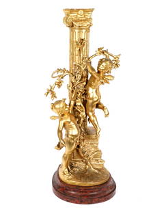
Sold2022Ferrand Gilt Bronze Angels and Roman ColumnFERRAND, Emile Justin, (French, 1846-1932): Gilt bronze figures of two cherubs, flowering branches and Roman column, signed at base, affixed to round marble base. Overall 24" h. x 9" x 7.5". ConditionSee Sold Price
Sold2022S. KIRK & SON "REPOUSSE" COIN SILVER FORKS, 11PCSamuel Kirk and Son Company, marks used 1846-1861, set of eleven coin silver "Repousse" (patterned active 1830-1865) forks, all appropriately marked. Approx. of one, h. l. 7.5""; total approx. weightSee Sold Price
Sold2020BRETT WESTON - Ice Forms, Oregon, 1974ARTIST: BRETT WESTON TITLE: 'Ice Forms, Oregon, 1974' MEDIUM: Vintage Silver Gelatin IMAGE SIZE: 9 5/8 x 7 3/4 in DESCRIPTION: This vintage silver gelatin print is signed and dated in pencil mount recSee Sold Price
Sold2023Original 1931 Chicago Gangland Map - FramedOriginal 1931 Chicago Gangland Map - Framed. As best as we can tell, this is an original from 1931. It measures roughly 28.5" x 22 7/8" without the frame. This a great historical Chicago piece! ThereSee Sold Price
Jun 02Schilb Antiquarian Rare Books1856 Fremont Illustrated American Exploration California Rocky Mountains SmuckerUS$1(1 bid)
May 30NY Elizabeth 1704 AN ANTIQUE DETAIL OF EVERY SEAT IN THE CURRENT WARS OF EUROPE W/MAPSUS$50(1 bid)
May 31Freeman's | Hindman[WESTERN AMERICANA]. A group of 5 letters sent from Missouri and hand-carried along the Oregon TrailUS$350
13 hrs LeftJasper52Turky [Turkey] in Europe by Herman Moll. Balkans Greece Black Sea 1709 old mapUS$70
13 hrs LeftJasper52German invasion of Belgium and France, May-June 1940. World War 2 1953 old mapUS$30


![[WESTERN AMERICANA]. A group of 5 letters sent from Missouri and hand-carried along the Oregon Trail (1 of 5)](https://p1.liveauctioneers.com/197/329785/177758567_1_x.jpg?height=282&quality=70&version=1715625218)


![Turky [Turkey] in Europe by Herman Moll. Balkans Greece Black Sea 1709 old map (1 of 1)](https://p1.liveauctioneers.com/5584/328641/177014336_1_x.jpg?height=282&quality=70&version=1715113718)


![[WILLIAMES, SHEDRICH] LOT OF 2 PRINTS TOGETHER (1 of 5)](https://p1.liveauctioneers.com/8124/329546/177689744_1_x.jpg?height=282&quality=70&version=1715469494)


