Sold2022American Hooked RugAmerican Hooked Rug United States, early 20th century Featuring an overall hit and miss pattern. Approximately 8 feet 2 inches x 5 feet 8 inches. Minor fraying to sides, faint stains. C The Estate ofSee Sold Price
Sold2023American Hooked RugAmerican Hooked Rug United States, early 20th century The allover rosette pattern on the slate grey field is within an animal-filled border, mounted on a wooden frame. Approximately 7 feet 2 inches xSee Sold Price
Sold2021Original Vintage c.1940 American Red Cross Poster LinenA nurse and two children stand on a map of the United States in this circa 1940 American Red Cross poster. The poster is linen mounted, measures 20" x 30" and is in excellent condition. A nurse and twSee Sold Price
2022Original Vintage c.1940 American Red Cross Poster Linen BackedA nurse and two children stand on a map of the United States in this circa 1940 American Red Cross poster. The poster is linen mounted, measures 20" x 30" and is in excellent condition. Reserve: $220.See Sold Price
Sold2017New England/Eastern United States 1940's Sunoco MapNew England/eastern united states 1940's sunoco map. The item is in good condition. Please note that this lot has a confidential reserve. When you leave a bid in advance of the auction, submit your maSee Sold Price
Sold2024Room Size Hooked RugRoom sized hook rug. North Eastern United States. Circa 1900. Condition: Excellent condition with minor edge binding fraying. 6' x 8'. Link for high-res images: https://www.dropbox.com/scl/fo/cyra3673See Sold Price
Sold2024American Hooked RugUnited States, Circa 1900 The central circular polychrome floral spray is on a buff field. (6' 3" x 6' 2") Small holes, restorations, soiledSee Sold Price
Sold2021TWO AMERICAN HOOKED RUGS.20th century. One is round with the seal of the United States. And the other is floral with a lavender border and grey field.See Sold Price
Sold20243 Antique Folk Art Scenic Bird Floral Hooked RugsUnited States,C 1900 The three piece lot includes the largest with floral basket flanked by a pair of birds, a snow scene landscape with horses, and a covered bridge with person and dog. Condition AllSee Sold Price
Sold2017National Geographic Map of Southwestern US Map, 1940The Southwestern United States map in the National Geographic Magazine dated June 1940. Measurement approximate: 26” x 35”. Condition: Very Good No Reserve: This lot starts at $1 and has no reservSee Sold Price
Sold2021EMBROIDERED TEXTILE, 1940, H 22.5", W 33", "STATEEMBROIDERED TEXTILE, 1940, H 22.5", W 33", "STATE FLOWER MAP" A 1940 embroidered textile titled "State Flower Map." Depicting the continental United States with state flowers. Frame measures H 25.25"See Sold Price
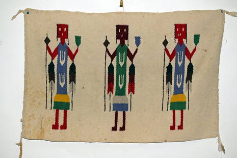
Sold2015Early Navajo Rug - Yei Pattern, ex-HistoriaSouthwestern United States, Navajo Reservation, Arizona or western New Mexico, ca. 1925 to 1940 CE. Very attractive Yei Rug. Woven with three figures in colors of purple, red and green. Black and goldSee Sold Price
Sold2023Vintage Souvenir Map of Worlds Fair Sponsor General MotorsGeneral Motors, Highways and Horizons World Fair list of displays, things to see and map. Issued: 1940 Dimensions: 5"L x 7.75"H Country of Origin: United StatesSee Sold Price
Sold2023World’s Fair Daily Event Calendar, Restaurants and MapIncludes alphabetical list of exhibitors. Fully opened 16in H x 13.5in L. Issued: 1940 Dimensions: 5.25"L x 8"H Country of Origin: United StatesSee Sold Price
Sold2018Map, United States, 1784, first map of the nationMap, United States, 1784,"Carte Des Etats-Unis De L'Amerique Suivant le Traite de Paix de 1783. Dediee et Presentee A.S. Excellence M. Benjamin Franklin Ministre Pleinipotentaire des Etats-Unis", theSee Sold Price
Sold2021Pictorial Map United States IndiansIndians of the U.S.A. Louise E. Jefferson. Friendship Press, New York: 1944. Novelty map showing native American tribes. Vintage color print. 22 1/2" x 34 1/2", overall 26" x 40".See Sold Price
Sold2016John Haven Map: United States and MexicoNew York: Haven & Emmerson, 1846 wood engraved, hand colored map created during the time of the Mexican American War. The map shows the United States and Mexico and includes the Oregon Territory, TexaSee Sold Price
Sold20231819 LIZARS MAP UNITED STATES.W & D Lizars Edinburgh map of the United Sates of America 1819, image 15” x 17,5” framed under glass overall 23” x 25”See Sold Price
Sold201718thc Map: United States of America, Wilkes, 1797Framed antique map, United States of America, Published London 1797 by J. Wilkes. Engraved by Neele, 352 Strand, London. Hand colored, the map shows the United States in the Decade after the AmericanSee Sold Price
Sold2022JOHN TALLIS (1817-1876) AN AMERICAN CIVIL WAR MAP, "United States," LONDON, CIRCA 1863,JOHN TALLIS (1817-1876) AN AMERICAN CIVIL WAR MAP, "United States," LONDON, CIRCA 1863, hand-colored lithograph on wove paper showing, "Federal, Non Slave Holding States (Red); Border, Slaveholding (BSee Sold Price
Sold2021CIVIL WAR-ERA JOHNSON'S MILITARY MAP UNITED STATESFramed engraving with color on paper, "Johnson's New Military Map of the United States, Showing the Forts, Military Posts & c., with Enlarged Plans of Southern Harbors from Authentic Data Obtained atSee Sold Price
Sold20221864 Civil War MAP United States Statistics Commerce1864 Civil War MAP United States Statistics Commerce American Trade Gold Silver The United States Department of Treasury published this Civil War-era report analyzing the commerce of the US GovernmentSee Sold Price
Sold2021Colton Railroad and County Map United States 1878Colton, after G. W., Colton's Railroad and County Map of the United States, The Canadas, &c, 1878, antique map on paper, folded as originally issued, 33 x 42 inches, in a wood frame 36.5 x 47.5 inchesSee Sold Price
Sold2016Antique Map United States Thomson's 1817Antique Map United States Thomson's 1817, authentic antique map, inscribed, "drawn & engraved for Thomson's new general atlas 1817", along with "Northern Provinces of the United States", hand coloredSee Sold Price