Sold2017National Geographic Map of Southwestern US Map, 1940The Southwestern United States map in the National Geographic Magazine dated June 1940. Measurement approximate: 26” x 35”. Condition: Very Good No Reserve: This lot starts at $1 and has no reservSee Sold Price
Sold2017Map Screen Of The United States National Geographic mapNational Geographic map of the U.S. divided into four section panels: east coast, Midwest, mountain states and west coast. West coast map missing. Panels are wood framed with plastic surfaces.See Sold Price
Sold2024National Geographic Maps 1940's and 1950's USA, Canada, Asia World MapNational Geographic Maps 1940's and 1950's USA, Canada, Asia World MapSee Sold Price
Sold2021HUNDREDS Nautical, Geology & World Geography MapsAn historical estate collection consisting of hundreds of individual maps and charts, produced by and for various sources. Includes original U.S. Geological Survey maps, National Geographic Society woSee Sold Price
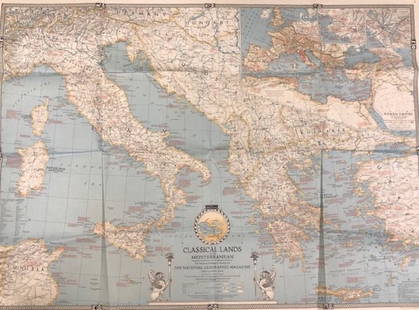
Sold2020Vintage National Geographic MagazineDescription: Vintage paper map from National Geographic Magazine, depicting the classical lands of the Mediterranean. Copyright 1940. Material: paper. Measurement: approximate 26.5"h x 34"w (INCHES).See Sold Price
Sold2022Vintage US Travel Destination Maps & BrochuresVintage travel destination magazines, brochures including a map for "The Mountain Empire of the West - Middle Park, Grand County, Colorado" (1934), 1940 maps of Yosemite, Yellowstone National parks asSee Sold Price
Sold2017Collection of 35 vintage mapsCollection of 35 vintage maps mostly from The National Geographic Magazine including Northern Africa; The Philippines; The Top of the World; Scandinavia; Northern Europe; Southwestern United States; JSee Sold Price
Sold2017MAP - Europe And The Near East - 33 x 39 – 1940Description: “Europe And The Near East” Map compiled and drawn – The National Geographic Society for The National Geographic Magazine- Gilbert Grosvenor, Editor. 33 x 39. Condition: Very Good.ShSee Sold Price
Sold2022(18) NATIONAL GEOGRAPHIC MAPS, c.1930s-1940s(lot of 18) National Geographic Maps, world maps dated late 1930s to 1940s, with many notes, mileage, and more, housed in book-form album, approx 10.75"h, 7.5"w, 2.25"d, 3.25lbs Start Price: $40.00See Sold Price
Sold2019ASSEMBLED LOT OF VINTAGE MAPSASSEMBLED LOT OF VINTAGE MAPS: Maps of the east coast, National Geographic maps, AAA road maps, 6 1/4" X 10 1/2" $40 - $80 Shipping:See Sold Price
Sold2024[AMERICAN NATIONAL PARKS]. North Half Shasta National Fores...[AMERICAN NATIONAL PARKS]. North Half Shasta National Forest. Recreation Map. U.S. Department of Agriculture, 1916. 30 x 50”. Outlined in several colors. Original folds, some soiling to pamphletSee Sold Price
Sold2018Antique Map of Southwestern US & MexicoTitle/Content of Map: Important Southwestern U.S., Texas to CA with Mexico and Guatemala Date Printed: 1843 Cartographer: Based on the work of H.C. Tanner Material/Medium: Paper Size: 17" x 14" Hand cSee Sold Price
Sold2017Phelps: Antique Pre-Civil War Map of United States 1848Patriotic Antique Pre-Civil War US Map; "Phelps's National Map of the United States, A Travellers Guide. Embracing the principal Rail Roads, Canals, Steam Boat & Stage Routes, Throughout the Union.".See Sold Price
Sold20191921 AAA Map of US National Parks"Map Showing National Park to Park Highways and Principle Automobile Highways in the Western United States 1921". Engraved and printed by the US Geological Survey and issued by the American AutomobileSee Sold Price
Sold2018Vintage Maps110+ Assorted California Maps; 50+ Assorted USA and World Maps; 25+ national Geographic Magazine Maps; 1950s -60s Classic Artistic. Road Maps of the Western States; 7Union Oil; Chevron Oil; Shell Oil;See Sold Price
Sold2018With State Seals /Presidents Surrounding U.S. MapAtwood, J. M. (1818-c. 1880) & Phelps, Humphrey (fl. c. 1830-1860). Phelps's National Map of the United States, a Travellers Guide... Engraved map. Ensign & Thayer, 1851. 20 ½" x 25 ¾" sheet. "ESee Sold Price
Sold20211939 Map1939 National Geographic map "The REACHES of NEW YORK CITY". 20" x 26".See Sold Price
Sold2022Vintage Discovery, Map, EphemeraThis lot consists of 1 postcard autographed by George Wallace, 4 invitation letters to the Space Shuttle Columbia liftoff in 1986, 1 $2 bill, various National Geographic maps (approx 30) and 3 AfricanSee Sold Price
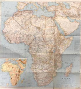
Sold2018National Geographic Map Africa 1943National Geographic magazine map for Africa . Date: 1943. Editor: Gilbert Grosvenor. Measurement approximate: 31 x 29. Shipping cost: $15.00See Sold Price
Sold2020Vintage National Geographic Map of AfricaDescription: Vintage color paper map from National Geographic Magazine depicts Africa. Some tearing on bottom. Map is copyrighted from 1943. Material: paper. Measurement: approximate 26.5"h x 34"w (INSee Sold Price
Sold2020(44)Vintage National Geographic Maps - Asst Regions(44)Vintage National Geographic Maps - Asst RegionsSee Sold Price
Sold2023135+ National Geographic Maps & 26 VHS Tapes135+ National Geographic Maps & 26 VHS TapesSee Sold Price
Sold2023Three National Geographic MapsThree National Geographic Maps, comprising one of the world, one of Japan and Korea, and one of China The largest: 38-1/4"h x 48-1/2"w overall; 31-1/2"h x 46-1/2"w sightSee Sold Price
Sold202140 +/- 1940's-1970's Nat'l Geographic Maps40 +/- National Geographic maps, from 1949-1979, includes Europe and The Near East with Russian and Polish boundaries according to treaties and claims as of April 1, 1949, post-World War II, ClassicalSee Sold Price
1 day LeftRapid Estate Liquidators and Auction Gallery6 1980s 1990s National Geographic Magazines AUS$35
3 days LeftPotter & Potter AuctionsBOURNE, Emma (1906 – 1986). America – A Nation of One Peopl...US$125(1 bid)
1 day LeftRapid Estate Liquidators and Auction Gallery6 Humans & Health National Geographic MagazinesUS$25
2 days LeftRapid Estate Liquidators and Auction Gallery7 2000 1990s National Geographic MagazinesUS$45
JG AutographsGeorge Doersch - WWII U.S. Army Air Forces Ace - Autographed Canadian Dec. of War 50 Anniv. CoverUS$10
6 days LeftMynt Auctions1940 Brooklyn Dodgers Team Signed Official National League Ford Frick BaseballUS$250
3 days LeftPotter & Potter AuctionsLINDGREN, Jolly (1895-1952). A Hysterical Map of Yellowstone Park and the Jackson Hole CountryUS$125
3 days LeftPotter & Potter AuctionsLINDGREN, Hjalmer “Jolly” (1895–1952). A Hysterical Map of ...US$200
May 22Thomaston Place Auction GalleriesCOLLECTION OF TRAVEL EPHEMERA, BROCHURES, BOOKLETS, MAPS 1900-1950US$100
2 days LeftWorld Auction Gallery LLCFramed Reproduction of an Antique Map of Iceland by Georgio CaroloUS$30
20 hrs LeftFleischer's AuctionsLincoln's Funeral Cortège Book by Custodian of Lincoln's TombUS$150(2 bids)
May 30Pandora AuctionsEarly Southwestern Sterling Silver, 18K Gold & Amethyst Signed Designer EarringsUS$45
BonhamsAnsel Adams (1902-1984); Jeffrey Pine, Sentinel Dome, Yosemite National Park, California;US$2,600(8 bids)
6 days LeftSOUTHWESTERN STYLE GALLERYNavajo Squash Blossom Necklace Kingman Turquoise Necklace Sterling SilverUS$1,000
6 days LeftSOUTHWESTERN STYLE GALLERYOld Pawn Navajo Thunderbird Ingot Link Bracelet Sterling Silver Turquoise 7"US$380
6 days LeftSOUTHWESTERN STYLE GALLERYNavajo Number 8 Turquoise Cuff Bracelet Adjustable Adam Fierro Native AmericanUS$395(1 bid)
6 days LeftSOUTHWESTERN STYLE GALLERYOld Pawn Navajo Cerillos Turquoise Cuff Bracelet Sterling Silver Native AmericanUS$360


![[AMERICAN NATIONAL PARKS]. North Half Shasta National Fores...: [AMERICAN NATIONAL PARKS]. North Half Shasta National Forest. Recreation Map. U.S. Department of Agriculture, 1916. 30 x 50”. Outlined in several colors. Original folds, some soiling to pamphlet](https://p1.liveauctioneers.com/928/312808/167423169_1_x.jpg?height=310&quality=70&version=1702503866)