Sold2023A map of the world on Mercators Projection. Davis Land. GENTS MAG 1755 oldTITLE/CONTENT OF MAP: 'A map of the World, on Mercators Projection' The map notes the European discovery of Alaska in 1741, and shows in dotted outline a pre-Cook guess at the east coast of Australia.See Sold Price
Sold2023c. 1755 Map Of the World Framedc. 1755 Map Of the World on Mercators Projection Framed. Gentleman's Magazine London 8 x 12.See Sold Price
Sold2023General Chart on Mercators Projection. World. Cook's route. PAYNE 1798 old mapTITLE/CONTENT OF MAP: 'General Chart on Mercators Projection' DATE PRINTED: 1798 IMAGE SIZE: Approx 18.0 x 25.0cm, 7 x 9.75 inches (Medium) TYPE: Antique copperplate engraved map with original hand coSee Sold Price
Sold2019MAP - Holy Land. Mercator/HondiusHoly Land. Mercator/Hondius, Peregrinatio Israelitaru in Deserto, 1610 (published). Hand Color. A handsome small map depicting the Exodus and the wandering of the Children of Israel. An inset of the ESee Sold Price
Sold2023MAP, China, Korea & Japan, MercatorHondius' Map of China, Korea, and Japan. China, Korea & Japan. Mercator/Hondius, China, from Gerardi Mercatoris - Atlas sive Cosmographicae, 1623 (published). Hand Color. Besides China, this map depicSee Sold Price
Sold2020World.- Purdy (John, hydrographer) A Chart of theWorld.- Purdy (John) A Chart of the World, on Mercator's Projection; with the Tracks of the more Distinguished Modern Navigators. Regulated throughout, according to the best Scientific Determinations,See Sold Price
Sold2020Mercator World Map*** START PRICE IS THE RESERVE *** [World] MERCATOR, Rumold (1545-1599). Orbis Terrae Compendiosa Descriptio Quam ex Magna Universali Mercatoris... Engraved Map with original hand color. Geneva, 1587.See Sold Price
Sold2022World.- Plancius (Petrus) Orbis Terrarum Typus de Integro Multis in Locis Emendatus auctore PetroWorld.- Plancius (Petrus) Orbis Terrarum Typus de Integro Multis in Locis Emendatus auctore Petro Plancio, double-hemisphere world map, after Mercator's world map of 1587, and the first map to show JaSee Sold Price
Sold2016[World Map]. Rumold Mercator. Orbis terrae compe[World Map]. Rumold Mercator. Orbis terrae compendiosa descriptio.&See Sold Price
Sold2023Mercator, Rumold (1545-1599) World MapAn engraved double-page double hemispheric world map, "Orbis Terrae Compendiosa Descriptio". Dimensions:Sight is 11 1/4" x 20 3/4", the frame 21" x 29 1/2". Provenance:From a Philadelphia Collection.See Sold Price
Sold2021MAP, Western Hemisphere, BlaeuBlaeu's Stunning Carte-a-Figures Map of the Americas in Full Contemporary Color. Western Hemisphere - America. Willem Blaeu, Americae Nova Tabula, 1642 (circa). Hand Color. This stunning carte-a-figurSee Sold Price
Sold2022MAPS IN BOOK, Atlases, CareyCarey's Famous 1814 General Atlas. Atlases. Mathew Carey, Carey's General Atlas, Improved and Enlarged: Being a Collection of Maps of the World and Quarters, Their Principal Empires, Kingdoms, &c., 18See Sold Price
Sold2024MAPS IN BOOKS, Atlases, Buy de MornasContains 135 Double-Page Maps in Contemporary Color. Atlases. Claude Buy de Mornas, [4 Volumes] Atlas Methodique et Elementaire de Geographie et d'Histoire, 1761-62 (published). Hand Color. A large anSee Sold Price
Sold20181695 Mercator Map of the Known World -- UniversalisTitle/Content of Map: 1695 Mercator Map of the Known World -- Universalis Tabula Iuxta Ptolemaeum Date: 1695, Amsterdam Cartographer: G Mercator Size: 13.7 x 18.6 in. This outstanding and decorative mSee Sold Price
Sold2020MERCATOR, RUMOLD. Orbis Terrae Compendiosa Descriptio.MERCATOR, RUMOLD. Orbis Terrae Compendiosa Descriptio. Double-page engraved double-hemispheric world map. 14½x21 inches sheet size, upper and lower margins wide, others narrow, French text on verSee Sold Price
Sold20211613 America sive India Nova ad magnae GerardiBy: Michael MercatorDate: 1613 / DuisbergDimensions: 16 x 19.5 inches (40.7 x 49.5 cm)This is an authentic antique map of the Western Hemisphere by Michael Mercator. The map is based on Rumold MercatoSee Sold Price
Sold2022TISSOT Navigator rare, limited gents wristwatchTISSOT Navigator rare, on 100 pieces limited gents wristwatch in 18k yellow gold with world time display reference OR 4001, Switzerland manufactured according to the old model with old movement from 1See Sold Price
2018Important World Map from the Nuremberg Chronicle, 1493Title/Content of Map: World Map from the Nuremberg Chronicle. One of the most important world Maps ever produced Date Printed: 1493 Cartographer: Hartmann Schedel Material/Medium: Paper Size: 18" x 25See Sold Price
Sold2022BRITISH ISLES LILY (GEORGE) Britanniae insulae quae nunc Angliae et Scotiae regna continet cum H...BRITISH ISLES LILY (GEORGE) Britanniae insulae quae nunc Angliae et Scotiae regna continet cum Hibernia adiacente nova descriptio, double-page engraved map, land masses hand-coloured, title cartoucheSee Sold Price
Sold2017Ortelius: Antique Map of the World, 1587Map: World Date Printed: 1587-1612 Cartographer: Abraham Ortelius Material/Medium: Paper Size: *** Approx 16" x 21" Original hand color. Copperplate engraved.One of the most famous and iconic world maSee Sold Price
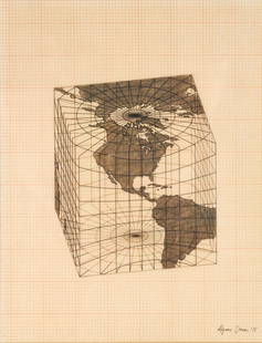
Sold2021Agnes Denes - Study of Distortions; Isometric SystemsLot 3 Agnes Denes Hungarian/American (b. 1931) Study of Distortions; Isometric Systems in Isotropic Space-Map Projections: The Cube (1975) gouache and ink on graph paper and mylar signed lower right sSee Sold Price
Sold2018Old World style iron solariumOld World style solarium in galvanized wrought iron, Powder Coated, Â Detailed Scroll Work, 17'h X 28'l X 15'wSee Sold Price
Sold2016T-O World Map.- Lucanus (Marcus Annaeus) Pharsalia,Lucanus (Marcus Annaeus) Pharsalia, manuscript on paper, [Northern Italy (possibly Padua), first half of the fifteenth century]. 294 x 217mm., I + 149 + I leaves (including defective leaves and 3 blanSee Sold Price
Sold2024Petrus Plancius, Engraved World MapOrbis Terrarum Typus de Integro Multis in Locis Emendatus. Petrus Plancius (1552-1622). Copper-plate engraving with original hand color in full. Amsterdam, 1594. Some stains, creases, folds. Sight sizSee Sold Price
5 days LeftPotter & Potter AuctionsTUNIS, Edward (1897 – 1973). From Chesapeake Bay / Land of ...US$250
5 days LeftPotter & Potter AuctionsCRAVATH, Glen (1897 – 1964). Py Your Leaf Baron Munchausen ...US$80
5 days LeftPotter & Potter AuctionsFLACHMAN, Chuck. Being a Map of Saint Louis / Home of Anheu...US$100
May 22Thomaston Place Auction GalleriesCOLLECTION OF TRAVEL EPHEMERA, BROCHURES, BOOKLETS, MAPS 1900-1950US$100
Jun 02Schilb Antiquarian Rare Books1871 Holy BIBLE & MAPS Holy Land Hitchcock Analysis Gruden Concordance TheologyUS$82(2 bids)
3 days LeftFleischer's Auctions1755 Map Partie de l'Amerique Septentrionale, qui comprend Le Cours de L'Ohio...US$200(3 bids)
3 days LeftAkiba Galleries(2 Pc) Allain Manesson Mallet Description De L'Univers 2 Vol. German TranslationUS$200(1 bid)
Jun 03The Art's WorldFERNANDO AMORSOLO - PREPARING THE MEAL - PAINTING - OIL ON CANVAS - IN THE STYLE OF€2,900
Jun 03The Art's WorldANGEL BOTELLO - FLORAL STILL LIFE - OIL PAINTING ON BOARD - IN THE STYLE OF€2,700


![Mercator World Map: *** START PRICE IS THE RESERVE *** [World] MERCATOR, Rumold (1545-1599). Orbis Terrae Compendiosa Descriptio Quam ex Magna Universali Mercatoris... Engraved Map with original hand color. Geneva, 1587.](https://p1.liveauctioneers.com/1968/163248/82424686_1_x.jpg?height=310&quality=70&version=1583340284)

![[World Map]. Rumold Mercator. Orbis terrae compe: [World Map]. Rumold Mercator. Orbis terrae compendiosa descriptio.&](https://p1.liveauctioneers.com/906/93415/47683584_1_x.jpg?height=310&quality=70&version=1473203012)


![MAPS IN BOOKS, Atlases, Buy de Mornas: Contains 135 Double-Page Maps in Contemporary Color. Atlases. Claude Buy de Mornas, [4 Volumes] Atlas Methodique et Elementaire de Geographie et d'Histoire, 1761-62 (published). Hand Color. A large an](https://p1.liveauctioneers.com/6576/320593/172252664_1_x.jpg?height=310&quality=70&version=1708729193)


![T-O World Map.- Lucanus (Marcus Annaeus) Pharsalia,: Lucanus (Marcus Annaeus) Pharsalia, manuscript on paper, [Northern Italy (possibly Padua), first half of the fifteenth century]. 294 x 217mm., I + 149 + I leaves (including defective leaves and 3 blan](https://p1.liveauctioneers.com/5458/94966/48431616_1_x.jpg?height=310&quality=70&version=1476369049)


