SoldAgnes Denes (American/Hungarian, b. 1931) Map Projection: The Snail, 1978Agnes Denes (American/Hungarian, b. 1931) Map Projection: The Snail, 1978 lithograph signed, dated, titled and numbered 11/50 in pencil 24 x 30 inches. Property from a Private Art Collection <See Sold Price
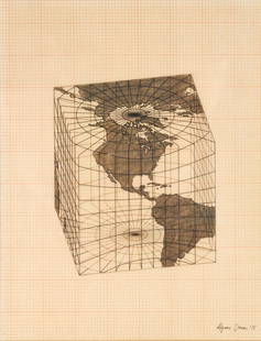
Sold2021Agnes Denes - Study of Distortions; Isometric SystemsLot 3 Agnes Denes Hungarian/American (b. 1931) Study of Distortions; Isometric Systems in Isotropic Space-Map Projections: The Cube (1975) gouache and ink on graph paper and mylar signed lower right sSee Sold Price
Sold2021Agnes DENES: "Probability Pyramid" - LithoEdition 1/40 lithograph titled "Probability Pyramid", by Agnes Dene (Hungarian, b. 1931). [Frame: 31 3/4" H x 43 1/2" W].See Sold Price
Sold2022Agnes Denes [COLUMBINE] Color lithograph and screenprint, framedAgnes Denes (b. 1938) [COLUMBINE] Color lithograph and screenprint, 1980, on wove paper, signed, dated and inscribed Kingdom Series and AP in pencil, with full margins, framed. Sheet 40 7/8 x 28 7/8 iSee Sold Price
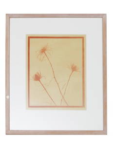
Sold2022VINTAGE AMERICAN MONOTYPE ON PAPER BY AGNES DENESAgnes Denes (Hungarian, American, born 1938) monotype on paper, Transparency of Roses, 1970s. Framed. Titled, dated, described on verso. Dimensions: Frame size: 17 x 14 1/2 in. Picture size: 10 3/4 xSee Sold Price
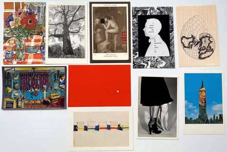
Sold2020Grouping of 10 Photo-Litho PostcardsFeaturing: Chris von Wangenheim, Tom Zetterstrom, Wayne Thiebaud, Massimo Vignelli, Agnes Denes, Nell Blaine, Manuel Casimiro, Tom Prassis, Jonathan Williams, Robert Cuneo Each: 4" x 6"See Sold Price
Sold2021SCOTTISH NEEDLEWORK MAP SAMPLER LATE 18TH/ EARLY 19THoutlined in silk on a linen ground, the place names in black, signed 'Agnes Watson/ Edinburgh' in a cartouche, mounted but unframed (Dimensions: 40cm x 34cm)(40cm x 34cm)Provenance: Property from TornSee Sold Price
Sold2019Strait of Magellan Map[Strait of Magellan Map] , "Fretum Magellannicum", by Theodore De Bry, Frankfurt, 1601, copper engraved, depicting ships, natives, a penguin and a snail, 6 1/2 in. x 11 3/4 in., framed IMPORTANT: AllSee Sold Price
Sold2024Nova Virginiae Tabula.Hondius, Henricus. Virginia. Amsterdam: Hondius, 1633-1665. Attractive map of the Chesapeake region, showing Virginia and Maryland, and based on John Smith's famous 1612 map, the most important map ofSee Sold Price
Sold2024Polo Austral O Meridionale & Antarctico.Coronelli, Vincenzo. Venice 1697. The map for the South Pole for the 45" terrestrial globe from Coronelli's "Libro Dei Globi", published in Venice 1697. Hemisphere 14" diameter, copper engraving on paSee Sold Price
Sold2024Chinese Broadsheet: Omen of a Fruitful Year (7th Year of the Emperor Tongzhi's rule; c.1868)China. ca. 1868. A rare Chinese broadsheet, published in the 7th year of Tongzhi, 1868 in the western calendar to celebrate Chinese New Year. Hand colored woodcut print with illustrations and text, deSee Sold Price
Sold2024Group of 8 Cigarette Advertising Cards for the Chinese Market.China; Tobacco. Ca. 1909-10. Scarce set of cards front color illustrated with scenes from old Chinese tales, Chinese text on verso. Issued by foreign companies to advertise in China, the companies incSee Sold Price
Sold2024The Voyages of Capt. James Cook Round the World; 1843 with handsome plates.Wright, William. London: W. Wright, 1843. A handsome 8vo edition, with interesting mezzotint and aquatint views not seen in other editions, with a particularly interesting rendition of the "Death of CSee Sold Price
Sold2024A twelve-leaf album of Chinese export paintings of Processionals.Pith Paintings; Kheshing. Canton: Kheshing Studio, c. 1860. With the Kheshing stamp in the front stating that they we26592re dealers in silks and other sundry articles. We can locate only one other liSee Sold Price
Sold2024Andre's Journal. An Authentic Record of the...Engagements of the British Army, 1 of 10 copies.Lodge, Henry Cabot. Boston: The Bibliophile Society, 1903. Limited edition. One of ten copies signed by William Bixby for presentation, with "Compliments of W. K. Bixby" at ffep. William Bixby owned tSee Sold Price
Sold2024A twelve-leaf album of Chinese export paintings of elegantly dressed Mandarins and their Women.Pith Paintings; Angsing. Canton: Angsing Studio, c. 1850. An album of finely executed paintings of the Empress, Emperor, and various other top officials including their wives or women, their robes depSee Sold Price
Sold2022John Smith Map of New England, Extremely Rare 2nd StateSMITH, John (1580-1631). New England the most remarqueable parts thus named by the high and mighty Prince Charles, Prince of great Britaine. Observed and described by Captayn John Smith... CopperplateSee Sold Price
2021GREAT NORTHERN’S 2 GREAT TRAINS SYSTEM MAP.Huge dramatic reverse glass advertising Great Northern's two great trains, Empire Builder and Western Star. In script just below Great Northern logo it states "Steamliners twice a day, each way, betweSee Sold Price
Sold2022[STREETER COPY] SEARCY, I. G. Map of Florida constructed principally from authentic documents in the[STREETER COPY] SEARCY, I. G. Map of Florida constructed principally from authentic documents in the Land office at Tallahassee by I. G. Percy. Published by I.G. Searcy Tallahassee & F. Lucas Jr., BalSee Sold Price
Sold2020Gastaldi Map of Africa*** START PRICE IS THE RESERVE *** [Africa]. GASTALDI, Giacomo (1500-1566) & FORLANI, Paolo (fl. 1560-1571). La Descrittione dell'Africa. Engraved Map. Venice: Paolo Forlani, 1562. 19 x 25 1/4 inchesSee Sold Price
Sold2016T-O World Map.- Lucanus (Marcus Annaeus) Pharsalia,Lucanus (Marcus Annaeus) Pharsalia, manuscript on paper, [Northern Italy (possibly Padua), first half of the fifteenth century]. 294 x 217mm., I + 149 + I leaves (including defective leaves and 3 blanSee Sold Price
Sold2024Petrus Plancius, Engraved World MapOrbis Terrarum Typus de Integro Multis in Locis Emendatus. Petrus Plancius (1552-1622). Copper-plate engraving with original hand color in full. Amsterdam, 1594. Some stains, creases, folds. Sight sizSee Sold Price
Sold2015A Fine & Rare Map of New York.Bernard Ratzer "Plan of the City of New York". Signed lower right in the plate "T. Kitchin Sculpt" (Kitchin recorded the cartographer's name as Ratzen (sic) rather than Ratzer). The map backed, rolledSee Sold Price
5 days LeftJasper52WEST CORNWALL. Land's End Lizard Penwith Roseland St Agnes St Ives CARY 1832 mapUS$260
Sep 30Eastern Art Auction HouseA pair of Qing court royal old red sandalwood vermilion lacquer bottom inlaid hundred throne screensUS$100
1 day LeftProvincetown Art Association and MuseumAgnes Weinrich, Teatime I, Wood printing blockUS$3,600(2 bids)
2 days LeftCarlsen Gallery, Inc.EARLY HAND COLORED MAP OF COLONIAL NEW ENGLAND 19" X 21 3/4"US$200(3 bids)
2 days LeftCarlsen Gallery, Inc.1730 HAND COLORED MAP OF NEW ENGLAND PRINTED AUGSBURG W/ RESTITUTIO VIEW OF NY BY SEUTTERI 25 1/4"US$175(2 bids)
20 hrs LeftSimpson Galleries, LLC.AGNES RICHMOND (American 1870-1964) A PAINTING, "Woman in Green Hat," 20TH CENTURYUS$600(2 bids)
2 days LeftCheck the Oil Promotions, LLCTexaco Travel Service Advertising Map Rack with 15 MapsUS$55(5 bids)
6 days LeftFrost & NicklausAgnes Huston, Still Life with Persimmons, Oil Painting on Canvas, 1936, FramedUS$260


![Agnes DENES: "Probability Pyramid" - Litho: Edition 1/40 lithograph titled "Probability Pyramid", by Agnes Dene (Hungarian, b. 1931). [Frame: 31 3/4" H x 43 1/2" W].](https://p1.liveauctioneers.com/1221/196403/99777990_1_x.jpg?height=310&quality=70&version=1615825772)
![Agnes Denes [COLUMBINE] Color lithograph and screenprint, framed: Agnes Denes (b. 1938) [COLUMBINE] Color lithograph and screenprint, 1980, on wove paper, signed, dated and inscribed Kingdom Series and AP in pencil, with full margins, framed. Sheet 40 7/8 x 28 7/8 i](https://p1.liveauctioneers.com/292/253542/131751272_1_x.jpg?height=310&quality=70&version=1656533559)

![Strait of Magellan Map: [Strait of Magellan Map] , "Fretum Magellannicum", by Theodore De Bry, Frankfurt, 1601, copper engraved, depicting ships, natives, a penguin and a snail, 6 1/2 in. x 11 3/4 in., framed IMPORTANT: All](https://p1.liveauctioneers.com/268/150890/76180328_1_x.jpg?height=310&quality=70&version=1569336980)


![[STREETER COPY] SEARCY, I. G. Map of Florida constructed principally from authentic documents in the: [STREETER COPY] SEARCY, I. G. Map of Florida constructed principally from authentic documents in the Land office at Tallahassee by I. G. Percy. Published by I.G. Searcy Tallahassee & F. Lucas Jr., Bal](https://p1.liveauctioneers.com/292/250642/130213737_1_x.jpg?height=310&quality=70&version=1654271664)
![Gastaldi Map of Africa: *** START PRICE IS THE RESERVE *** [Africa]. GASTALDI, Giacomo (1500-1566) & FORLANI, Paolo (fl. 1560-1571). La Descrittione dell'Africa. Engraved Map. Venice: Paolo Forlani, 1562. 19 x 25 1/4 inches](https://p1.liveauctioneers.com/1968/163248/82424552_1_x.jpg?height=310&quality=70&version=1583340284)
![T-O World Map.- Lucanus (Marcus Annaeus) Pharsalia,: Lucanus (Marcus Annaeus) Pharsalia, manuscript on paper, [Northern Italy (possibly Padua), first half of the fifteenth century]. 294 x 217mm., I + 149 + I leaves (including defective leaves and 3 blan](https://p1.liveauctioneers.com/5458/94966/48431616_1_x.jpg?height=310&quality=70&version=1476369049)


