Sold2019Strait of Magellan Map[Strait of Magellan Map] , "Fretum Magellannicum", by Theodore De Bry, Frankfurt, 1601, copper engraved, depicting ships, natives, a penguin and a snail, 6 1/2 in. x 11 3/4 in., framed IMPORTANT: AllSee Sold Price
Sold201818th C. Map of Australia w/Strait of Magellan18th c. framed map of Australia w/the Strait of Magellan. Copper engraved map, hand colored, w/ large colored pictorial cartouche, by Bernaidus Joannis Manasterienfis. Visible paper measures approximaSee Sold Price
Sold2023J. DE HONDT, COLOR MAP OF STRAITS OF MAGELLANJoost de Hondt (Belgian 1563-1612), "Freti Magel Lanici Ac Novi Freti Vulgo, Le Maitre Exactissima Delineatio", hand colored map of the Straits of Magellan, Le Maire Strait, Fire Lands and the southerSee Sold Price
Sold2023Détroit de Magellan. Strait of Magellan. Chile. BONNE 1790 old antique map[Voyage des Capitaines Byron, Vallis et Carteret] Détroit de Magellan avec les Plans des principaux Ports, Bayes &c. de ce Détroit // Havre Swalow ou de l'Hirondelle // Baye du Cap Upright // BaSee Sold Price
Sold2018Bellin: Chart of the Strait of Magellan 1760Map: Carte Reduite du Detroit de Magellan Cartographer: Bellin Place & Date: Paris / 1753/1760 Size: 13 1/2" x 9" Condition: b&w; old fold; margins extended with contemporary paper to fit the size ofSee Sold Price
Sold2024Antique Map - South America - Chart of Strait of Magellan - Patagonia - ChileThis large, original copper engraved, antique map, a chart of the Straits of Magellan, South America and the Patagonian & South Chilean shoreline was engraved by Robert Benard and published in theSee Sold Price
Sold2019Moore: Bougainville Claims Magellan Strait for FranceMap Title: M. Bougainville hoisting French Colours on a small Rock, in Magellan Streights Cartographer: Moore / Hogg / Vangro / Royce Place/Date: London / 1778 Size: 6 3/4" x 11" Condition: b&w; lightSee Sold Price
Sold2023GROUP OF 5 HAND COLORED MAPS OF THE AMERICASGroups of five hand colored antique maps of the Americas, comprising "America Merioio-Nalis (South American)" circa 1620, "Tabula Magellanica Qua Tierre Del Fuego (Strait of Magellan)" circa 1640, "IlSee Sold Price
Sold2016Strait of Magellan, Jodocus Hondius 1606-33Title: Freti Magellanici ac novi Freti vulgo Le Maire Subject: Strait of Magellan Maker: Jodocus Hondius Date: 1606-33, Amsterdam Size: 15.1 x 19.25 inches This is one of the best known early maps ofSee Sold Price
Sold20241756 Straits of Magellan, Cape Virgin Mary, Patagonia, by G. AnsonTitle: 1756 Straits of Magellan, Cape Virgin Mary, Patagonia, by G. Anson Date/Period: 1756 Materials: Copper plate engraved Size: 17 x 11 ? This 1756 map depicts Cape Virgin Mary, the north entranceSee Sold Price
Sold2020STRAITS of MAGELLAN & TIERRA DEL FUEGO calledTitle: STRAITS of MAGELLAN & TIERRA DEL FUEGO called MAGELLANICA, with Cape Horn Date/Period: 1642-1665 Materials: Copperplate engraved Size: 18 1/4 x 21”. Maps shows the southern most tip of SouthSee Sold Price
Sold2016Antique Map, Eastern Passages to China, Horsburgh19th century antique map: Eastern Passages To China Sheet 1 (Java, Bali, Lombock, Sumbawa, Southern Borneo, Celebes, etc.). Includes Sketch of the Bally Strait. Map maker James Horsburgh, London 1848.See Sold Price
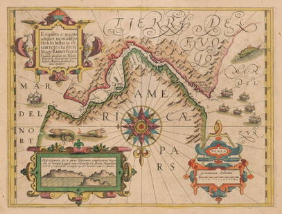
Sold2017Mercator: Strait of Magellan, Terra del Fuego, 1613Exquisita & magno aliquot mensium periculo Lustrata et iam retecta Freti Magellanici Facies . . . By: Gerard Mercator. Date: 1613 / Amsterdam. Dimensions: 14 x 18 inches (35.5 x 45.7 cm) This is an auSee Sold Price
Sold2022Large chart of Strait of Magellan 1787Heading: (South America) Author: Schraembl, Franz Anton Title: Karte der Magellanischen Strasse von Herrn Don Iuan de la Cruz Cano y Olmedillo... Place Published: Wien Publisher:Jos. Gerstner DatSee Sold Price
Sold20191844 Pacific Voyages D’Urville Australia MAP Magellan1844 Pacific Voyages D’Urville Australia MAP Magellan Cook Anson Vancouver MAPS Jules Dumont D’Urville was a 19th-century French explorer who is best known for his voyages in the South Pacific andSee Sold Price
Sold2023Lot of 3 Books by Rockwell Kent, Voyaging The Strait Of Magellan 1924, Salamina 1935, N by E 19351) Voyaging Southward From The Strait Of Magellan, with illustrations by the Author. Published by Halcyon House, New York 1924, Fourth Printing. Good condition. 2) Salamina, illustrated by the Author.See Sold Price
Sold2022Strait of Magellan from French Cook 1778Heading: (South America) Author: Bernard, Jean Frederic Title: Carte du Detroit de Magellan dans laquelle on an Insere les Observations et les Decouvertes du Capne. Byron, du Capne. Wallis, et du CapnSee Sold Price
Sold2018Benard: Magellan Strait with Coastal ProfilesA large-scale dramatic chart of the Magellan Strait with extensive coastal detail and four coastal profiles, based on the observations and discoveries of Captains Byron, Wallis, and Carteret.; G642; BSee Sold Price
Sold2017VOYAGING SOUTHWARD FROM THE STRAIT OF MAGELLANBy Rockwell Kent, 1924. Filled with illustrations by the author. Ht. 29 cm. (11 1/2 in.) Approx. weight 1.1 kg.See Sold Price
Sold2018Depot de la Marine 1885 Map Strait of Bonifacio Corsica"Bouches de Bonifacio" Steel Engraved Map Published 1885, Paris. Issued by the Depot de la Marine. Folded vertically and horizontally. Paper Size: 42 x 28.5 inch (107 x 73cm) Approx. Some margins faulSee Sold Price
Sold2018Strait of Sunda Compiled from Recent Surveys ... 1868Title/Content of Map: Strait of Sunda Compiled from Recent Surveys ... 1868 Date: 1871 Cartographer: IMRAY, JAMES Size: 38.5 X 39.5 Blue back sea chart with many soundings. Seven insets and ten headlaSee Sold Price
Sold20181779 History of America Robertson Columbus Cortez1779 History of America Robertson Columbus Cortez Magellan Mexico MAP Italian 4v “A historical classic! The first successful attempt to write a scholarly history of the Western Hemisphere.” (GSee Sold Price
Sold2018Rockwell Kent's Voyaging inscribed - 1st Russian ed.Heading: Author: Kent, Rockwell Title: Voyaging Southward from the Strait of Magellan - Russian Language Edition Place Published: Moscow Publisher: Date Published: 1966 Description: </See Sold Price
Sold2016Rockwell Kent. Voyaging. 1924Kent, Rockwell. VOYAGING SOUTHWARD FROM THE STRAIT OF MAGELLAN. NY: Putnam's Sons, 1924. First trade edition. 4to. Numerous illustrations throughout by Kent. Pictorial cloth in partial original jacketSee Sold Price
Crawford Family Auctions LLCVintage 1943 US DOC Coronation Island to Lisianski Strait Survey MapUS$10
Crawford Family Auctions LLCVintage 1944 US DOC Survey Map Hecate Strait to Etolin Island incl. Behm & Portland CanalsUS$10
Featured2 days LeftJasper52MEDITERRANEAN PORTS. Marseille Gibraltar Valetta Naples Algiers Piraeus 1903 mapUS$30
2 days LeftJasper52EUROPE.Balearic islands.Heligoland Gibraltar Andorra Riviera.JOHNSTON 1900 mapUS$20
2 days LeftJasper52EUROPE.Balearic islands.Heligoland Gibraltar Andorra Riviera.JOHNSTON 1903 mapUS$20
2 days LeftJasper52A Chart of the Sea Coast from England to the Streights. MOUNT & PAGE 1758 mapUS$500
2 days LeftJasper52EUROPE.Balearic islands.Heligoland Gibraltar Andorra Riviera. JOHNSTON 1906 mapUS$20
17 hrs LeftFleischer's Auctions1755 Map Partie de l'Amerique Septentrionale, qui comprend Le Cours de L'Ohio...US$200(3 bids)
5 days LeftBlackstone Valley Auctions & Estates LLCRevolutionary Era War Map of the Attack on Ft. Moultrie.US$225(3 bids)
2 days LeftUniversity ArchivesFeb. 1777 Issue of The Gentleman's Magazine with Superb Map of PhiladelphiaUS$140(1 bid)
Jun 07Freeman's | Hindman[MAP]. TODESCHI, Pietro. [Nova et Acurata Totius Americae Tabula auct. G.I. Blaeu] America quartaUS$5,000
JG AutographsBuckminster Fuller - Architect, Inventor, Futurist - Autographed Spaceship Earth Sky-Ocean Map ModelUS$80(8 bids)
May 29Cedarburg Auction & Appraisals LLCSet of Four Maps Showing All of Spain and PortugalUS$25(1 bid)
2 days LeftWorld Auction Gallery LLCFramed Reproduction of an Antique Map of Iceland by Georgio CaroloUS$30


![Strait of Magellan Map: [Strait of Magellan Map] , "Fretum Magellannicum", by Theodore De Bry, Frankfurt, 1601, copper engraved, depicting ships, natives, a penguin and a snail, 6 1/2 in. x 11 3/4 in., framed IMPORTANT: All](https://p1.liveauctioneers.com/268/150890/76180328_1_x.jpg?height=310&quality=70&version=1569336980)


![Détroit de Magellan. Strait of Magellan. Chile. BONNE 1790 old antique map: [Voyage des Capitaines Byron, Vallis et Carteret] Détroit de Magellan avec les Plans des principaux Ports, Bayes &c. de ce Détroit // Havre Swalow ou de l'Hirondelle // Baye du Cap Upright // Ba](https://p1.liveauctioneers.com/5584/294908/156576972_1_x.jpg?height=310&quality=70&version=1688565030)


![[MAP]. TODESCHI, Pietro. [Nova et Acurata Totius Americae Tabula auct. G.I. Blaeu] America quarta (1 of 1)](https://p1.liveauctioneers.com/197/329395/177650542_1_x.jpg?height=282&quality=70&version=1715364962)


