Sold2020Map to Explain the History of the Assyrians BabyloniansTitle: Map to Explain the History of the Assyrians Babylonians Medes and Persians. Cartographer: D'ANVILLE, J. B. B. Publication Date: c1740 Size: Height: 10 Width: 15.75 "Made by Mr. d'Anville, geogrSee Sold Price
Sold201810 Maps, mainly Rollin's Ancient History, 1739-40.[Middle East/Mediteranean/Antiquities] 10 Maps. ++ 9 maps after D’Anville from an edition of Rollin’s “Ancient History…,” cartouches 1739-1740, (nd). Various regions of the ancient Middle EaSee Sold Price
Sold2020Rollin, Charles 1780 Map of Armenia, Holy Land, Caspian"History of the Assyrians, Babylonians, Medes and Persians" Copper Engraved Map Published 1780, London for "The Ancient History..." by Charles Rollin. Folds as issued. Paper Size: 17.5 x 10.5 inch (25See Sold Price
Sold20211747 1ed JEWS Assyrian Empire Babylon MAPS Phrygians1747 1ed JEWS Assyrian Empire Babylon MAPS Phrygians Hebrews Judaica The “Universal History” is a mid-18th-century history of the world. Written by numerous authors and contributors, this enormousSee Sold Price
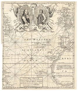
Sold20171740 Ornate Copperplate Engraved Portrait MapHistoric Maps 1740 Ornate Copperplate Engraved Map with Portraits of British Admirals “Robert Blake” & “Edward Vernon, Esq.” 1740-Dated, Copperplate Engraved Map titled “A New Map or Chart oSee Sold Price
Sold2017Seutter: Opulentissimum Sinarum Imperium Map, 1740Opulentissimum Sinarum Imperium. Asia with Korea as Peninsula map by M. Seutter, 1740 (62.5 x 52.5 cm) Please note that this lot has a confidential reserve. When you leave a bid in advance of the auctSee Sold Price
Sold2016[Civil War; Map] History of the War [1864]Bishop, John S., Capt.: A CONCISE HISTORY OF THE WAR. DESIGNED TO ACCOMPANY PERRINE'S NEW WAR MAP OF THE SOUTHERN STATES.... Indianapolis. [1864]. 132, xi, [1] pp. plus large folding map. 5.75" x 3.75See Sold Price
Sold2017Homann: British West Indies/Atlantic Islands Map, 1740Map: Dominia Anglorum. British West Indies/Atlantic islands of St Christopher (St Kitts), Antigua, Bermuda, Jamaica & Barbados Date Printed: c1740 Image Size: Approx 52.5 x 59.5cm, 20.5 x 23.25 inchesSee Sold Price
Sold20211794 Anville Map of the Arabian Peninsula and Red SeaTitle: 1794 Anville Map of the Arabian Peninsula and Red Sea -- A New Map of Arabia Divided into its Several Regions and Districts from Mons. D'Anville… Cartographer: J d'Anville / Larie and WhittleSee Sold Price
Sold2018Western or Atlantic Ocean Color Map 1740A New Map or Chart of the Western or Atlantic Ocean, with part of Europe, Africa & America. 1740. Printed for E. Cave, London. 15" x 12". We ship all items in this auction in-house with the most fairSee Sold Price
Sold2017Map & History of Battle of Gettysburg 1933- Buohl'sPublished by Buohl's. Map and History of the Battle of Gettysburg 1933 the Item Is in Good Condition. Please note that this lot has a confidential reserve. When you leave a bid in advance of the auctiSee Sold Price
Sold20231844 Napoleon Bonaparte WAR MAPS History by Jacques Norvins French Revolution1844 Napoleon Bonaparte WAR MAPS History by Jacques Norvins French Revolution Napoléon Bonaparte was the most prominent Military leader during the French Revolution and led many successful campaignSee Sold Price
Sold2016Adirondack NY Fishing, Maps History BooksA group of 3 books. 1. Hallock, Charles. The Fishing Tourist; Angler's Guide and Reference Book. New York Harper & Bros. 1873 (Front cover partially detached). Illustrated.2. 1900 Adirondack Maps StatSee Sold Price
Sold20181740 Seutter Map of Japan -- Imperium Japonicum perTitle/Content of Map: 1740 Seutter Map of Japan -- Imperium Japonicum per Sexaginta et Sex Regiones Digestum atque ex Ipsorum Japonensium Mappis Descriptum … Date: 1740 c., Augsburg Cartographer: MSee Sold Price
Sold20181740 Rupprech/Haffner Antique View of LondonTitle/Content of Map: 1740 Rupprech/Haffner View of London -- Lodinium [or] Prospectus Londinum, Sedes Regia, et praecipua Urbs in Anglia ad Temesium Fluvium . . . Date Printed: 1740 c. Augsburg CartoSee Sold Price
Sold2017Rupprech/Haffner: Antique Map View of Geneva, 1740Title/Content of Map: 1740 Rupprech/Haffner View of Geneva -- Genf Date Printed: 1740 c. Augsburg Cartographer: MA Rupprecht / J C Haffner Size: 12 x 15.6 in. A rare "vue d'optique" (with mirror imageSee Sold Price
Sold20191763 d'Anville Map of Western Roman Empire from Spain,Title/Content of Map: 1763 d'Anville Map of Western Roman Empire from Spain, England, Germany, Italy to Hungary to Africa -- Orbis Romani Pars Occidentalis Auspiciis Serenissimi Principis . . . MDCCLXSee Sold Price
Sold20191764 d'Anville Map of Eastern Roman Empire from BlackTitle/Content of Map: 1764 d'Anville Map of Eastern Roman Empire from Black Sea Region to Middle East -- Orbis Romani Pars Orientalis Auspiciis Serenissimi Principis . . . MDCCLXIV Date: 1764, LondonSee Sold Price
Sold20191764 d'Anville Map of Ancient Italy -- Tabula ItaliaeTitle/Content of Map: 1764 d'Anville Map of Ancient Italy -- Tabula Italiae Antiquae Geographica . . . MDCCLXIV Date: 1764, London Cartographer: J d'AnvilleSize: 24.2 x 19.2 in. An excellent large forSee Sold Price
Sold20221764 d'Anville Map of Ancient Italy -- Tabula ItaliaeTitle: 1764 d'Anville Map of Ancient Italy -- Tabula Italiae Antiquae Geographica . . . MDCCLXIV Cartographer: J d'Anville Year / Place: 1764, London Map Dimension (in.): 26.4 x 21.7 in. An excellentSee Sold Price
Sold20201764 d'Anville Map of Turkey and Parts of the MiddleTitle: 1764 d'Anville Map of Turkey and Parts of the Middle East -- Asiae, quae vulgo Minor Dicitur, et Syriae, Tabula Geographica… Year/Place: 1764, London Cartographer: J d'Anville Size: 20 x 24.5See Sold Price
Sold20211904 Map of the Panama CanalOfficial Map History and Workings of the Panama Canal published by J. J. Millroy, Washington D.C. 1904 Very Good Condition for its age.See Sold Price
Sold20191767 d'Anville Map of Ancient Palestine -- PalaestinaTitle/Content of Map: 1767 d'Anville Map of Ancient Palestine -- Palaestina by Mons. d'Anville of the Royal Academy … Date: 1767, London Cartographer: J d'AnvilleSize: 14.8 x 16.8 in. This is a niceSee Sold Price
Sold20181762 d'Anville Map of Ancient Greece -- GraeciaeTitle/Content of Map: 1762 d'Anville Map of Ancient Greece -- Graeciae Antiquae Specimen Geographicum Date: 1762, London Cartographer: J d'Anville Size: 20 x 19.1 in. A very nice larger map Ancient GrSee Sold Price
3 days LeftSchilb Antiquarian Rare Books1844 Siege of Gibraltar American Revolution SPAIN France Drinkwater MAP HistoryUS$2(2 bids)
6 days LeftJasper52German invasion of Belgium and France, May-June 1940. World War 2 1953 old mapUS$30
6 days LeftJasper52Home Waters. Blockade of Germany. Minefields. 1914. First World War. 1920 mapUS$20
6 days LeftJasper52Battle of Heligoland Bight, 28th August 1914. Principal Phases. WW1. 1920 mapUS$20
6 days LeftJasper52Pursuit of SMS Goeben & Breslau. 3-5th August 1914. First World War. 1920 mapUS$25
6 days LeftJasper52Operation Dragoon 15 August 1944. Assault. Invasion of South of France 1961 mapUS$30
6 days LeftJasper52Pursuit of SMS Goeben & Breslau. 6-10th August 1914. First World War. 1920 mapUS$30
6 days LeftJasper52Bombardment of Yarmouth & Lowestoft. 25th April, 1916. Tactical plan 1923 mapUS$35
7 days LeftPotter & Potter AuctionsMcCARTY, Lea (1905 – 1960). Sonoma County / Its Highlights ...US$100(1 bid)
May 17Albion AuctionsSale & Psalmanazar 1779 Map. Paradise Mount Ararat & Babel. Holy LandUS$10(2 bids)
May 17Albion AuctionsSale & Psalmanazar 1779 Map. Syria after the Death of Alexander the GreatUS$10(2 bids)
7 days LeftZikorn Arts & History ObjectsWest Indies, Providence, Windward, Cuba 1834 British Admiralty MapUS$100(1 bid)
7 days LeftZikorn Arts & History ObjectsEntrance to Baltic Great & Little Belt 1852 British Admiralty MapUS$100


![10 Maps, mainly Rollin's Ancient History, 1739-40.: [Middle East/Mediteranean/Antiquities] 10 Maps. ++ 9 maps after D’Anville from an edition of Rollin’s “Ancient History…,” cartouches 1739-1740, (nd). Various regions of the ancient Middle Ea](https://p1.liveauctioneers.com/179/117971/60557774_1_x.jpg?height=310&quality=70&version=1520636872)


![[Civil War; Map] History of the War [1864]: Bishop, John S., Capt.: A CONCISE HISTORY OF THE WAR. DESIGNED TO ACCOMPANY PERRINE'S NEW WAR MAP OF THE SOUTHERN STATES.... Indianapolis. [1864]. 132, xi, [1] pp. plus large folding map. 5.75" x 3.75](https://p1.liveauctioneers.com/3532/91776/46880401_1_x.jpg?height=310&quality=70&version=1469669287)


![1740 Rupprech/Haffner Antique View of London: Title/Content of Map: 1740 Rupprech/Haffner View of London -- Lodinium [or] Prospectus Londinum, Sedes Regia, et praecipua Urbs in Anglia ad Temesium Fluvium . . . Date Printed: 1740 c. Augsburg Carto](https://p1.liveauctioneers.com/5584/119241/60884161_1_x.jpg?height=310&quality=70&version=1522196518)


