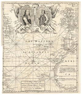
Sold20171740 Ornate Copperplate Engraved Portrait MapHistoric Maps 1740 Ornate Copperplate Engraved Map with Portraits of British Admirals “Robert Blake” & “Edward Vernon, Esq.” 1740-Dated, Copperplate Engraved Map titled “A New Map or Chart oSee Sold Price
Sold2020John Senex Map of North and South America 1719-17John Senex (1678–1740), "A New Map of America from the Latest Observations," London, ca. 1719-1721. Hand colored copperplate engraved map of North and South America, from Senex's "New General ASee Sold Price
Sold2018Seutter: Antique Map of the World, 1740Title/Content of Map: World by Seutter Date Printed: c1740 Cartographer: Matthaus Seutter Material/Medium: Paper Size: 24" x 19 1/2" Original hand colored Copperplate engraved. Published in Augsburg iSee Sold Price
Sold2018Seutter: Antique Map of Africa, 1740Title/Content of Map: Africa by Seutter c1740 Cartographer: Matthaus Seutter Material/Medium: Paper Size: 24" x 19 1/2" Original hand colored Copperplate engraved. Published in Augsburg in 'Atlas NovuSee Sold Price
Sold2018Bellin / la Harpe: Antique Map of the World, 1740Title/Content of Map: Rare large world Map Date Printed: 1740-1770's Cartographer: J.N. Bellin & J.F. La Harpe Material/Medium: Paper Size: 21 1/4" x 28" Copperplate engraved. From the 'Abrege de L'HiSee Sold Price
Sold2018Map of Asia by Seutter, 1740Title/Content of Map: Asia by Seutter Date Printed: c1740 Cartographer: Matthaus Seutter Material/Medium: Paper Size: 23" x 19" Provenance: New York Original hand colored copperplate engraved. PublishSee Sold Price
2018Seutter: Antique Map of Holy Land, 1740Title/Content of Map: Holy Land by Sutter Date Printed: c1740 Cartographer: Matthaus Seutter Material/Medium: Paper Size: 24" x 19 1/2" Original hand colored Copperplate engraved. Published in AugsburSee Sold Price
Sold2018Seutter: Antique Map of Europe, 1740Title/Content of Map: Europe by Seutter Date Printed: c1740 Cartographer: Matthaus Seutter Material/Medium: Paper Size: 19" x 23" Original hand colored copperplate engraved. Published in Augsburg. PubSee Sold Price
Sold2018Bellin: Antique Map of South Pole & Southern HemisphereTitle/Content of Map: South Pole & Southern Hemisphere Date Printed: 1740-70's Cartographer: J.N. Bellin & J.F. La Harpe Material/Medium: Paper Size: 22 1/4" x 22 1/4" Copperplate engraved. From the 'See Sold Price
Sold2018Seutter: Antique Map of France, 1740Title/Content of Map: France by Seutter Date Printed: c1740 Cartographer: Matthaus Seutter Material/Medium: Paper Size: 23 3/4" x 19 3/4" Original hand colored copperplate engraved. Published in AugsbSee Sold Price
Sold2018Seutter: Antique Map of Belgium, 1740Title/Content of Map: Belgium by Seutter Date Printed: c1740 Cartographer: Matthaus Seutter Material/Medium: Paper Size: 19" x 23" Original hand colored copperplate engraved. Published in Augsburg. PuSee Sold Price
Sold2018Bellin: Antique Map of Northern Philippines, 1740Title/Content of Map: Northern Philippines Date Printed: 1740's-70's Cartographer: J.N. Bellin & J.F. La Harpe Material/Medium: Paper Size: 6" x 9 3/4" Copperplate engraved. From the 'Abrege de L'HistSee Sold Price
Sold2018Bellin: Antique Map of Iceland, 1740Title/Content of Map: Iceland by Bellin Date Printed: 1740-70's Cartographer: J.N. Bellin & J.F. La Harpe Material/Medium: Paper Size: 17" x 14" Copperplate engraved. Published in Paris. From the 'AbrSee Sold Price
Sold2018Bellin: Antique Map of Japan, 1740Title/Content of Map: Japan by Bellin Date Printed: 1740-70's Cartographer: J.N. Bellin & J.F. La Harpe Material/Medium: Paper Size: 13" x 10" Copperplate engraved. From the 'Abrege de L'Histoire GeneSee Sold Price
Sold2018Bellin: Antique Map of Southeast Asia, 1740Title/Content of Map: Burma, Thailand, Cambodia, Laos & Vietnam Date Printed: 1740-70's Cartographer: J.N. Bellin & J.F. La Harpe Material/Medium: Paper Size: 11 1/2" x 12 1/2" Copperplate engraved. FSee Sold Price
Sold2018North Sea countries. Rare Map of Scandanavia. BritishNorth Sea countries. Rare Map of Scandanavia. British isles to Greenland 1740-70's J.N. Bellin & J.F. La Harpe 14 1/2" x 19 1/3" Copperplate engraved. Published in Paris. From the 'Aberge de L'HistoirSee Sold Price
Sold2018Bellin: Antique Map of West Indies, 1740Title/Content of Map: West Indes by Bellin Date Printed: 1740-70's Cartographer: J.N. Bellin & J.F. La Harpe Material/Medium: Paper Size: 13" x 16" Copperplate engraved. Published in Paris. From the 'See Sold Price
Sold2018Bellin: Antique Map of Indonesia & Malayasia, 1740Title/Content of Map: Indonesia & Malayasia Date Printed: 1740-70's Cartographer: J.N. Bellin & J.F. La Harpe Material/Medium: Paper Size: 13" x 11 1/2" Copperplate engraved. From the 'Abrege de L'HisSee Sold Price
Sold2017Bellin: Antique Map of Mexico City, 1740Title/Content of Map: Mexico City by Bellin Date Printed: c 1740-70's Cartographer: J.N. Bellin & J.F. La Harpe Material/Medium: Paper Size: 6 1/2" x 10" Copperplate engraved. Published in Paris. FromSee Sold Price
Sold2018Bellin: Antique Map of Southern Philippines, 1740Title/Content of Map: Southern Philippines Date Printed: 1740-70's Cartographer: J.N. Bellin & J.F. La Harpe Material/Medium: Paper Size: 14 1/3" x 9" Copperplate engraved. From the 'Abrege de L'HistoSee Sold Price
Sold2017Bellin: Antique Map of Canada's St Laurence River, 1740Title/Content of Map: Canada's St. Laurence river region by Bellin Date Printed: c 1740-70's Cartographer: J.N. Bellin & J.F. La Harpe Material/Medium: Paper Size: 14" x10" Copperplate engraved. PubliSee Sold Price
Sold2018Bellin: Antique Map Northern India Mughal Empire, 1740Title/Content of Map: Northern India Mughal Empire Date Printed: 1740-70's Cartographer: J.N. Bellin & J.F. La Harpe Material/Medium: Paper Size: 16" x 11" Copperplate engraved. From the 'Abrege de L'See Sold Price
Sold2018Bellin: Antique Map of St. Christopher, 1740Title/Content of Map: St. Christopher Date Printed: 1740-70's Cartographer: Bellin Material/Medium: Paper Size: 14" x 9 1/2" Published in Paris. Copperplate engraved. Please note that this lot has a cSee Sold Price
Sold2018Bellin: Antique Map of Iceland and Greenland, 1740Title/Content of Map: Iceland and Greenland Date Printed: 1740-70's Cartographer: J.N. Bellin & J.F. La Harpe Material/Medium: Paper Size: 13 1/2" x 10" Published in Paris. Copperplate engraved. FromSee Sold Price
7 days LeftJasper52Turkey in Europe & Hungary. Balkans Ukraine Greece Wallachia. WALKER c1795 mapUS$40
7 days LeftJasper52Le Nord de l'Europe contenant le Danemark… Scandinavia Russia. BONNE 1780 mapUS$35
7 days LeftJasper52L'Allemagne, La Boheme, et La Hongrie; avec…partie de Pologne. BONNE 1780 mapUS$60
7 days LeftJasper52Hungary &c with Turky in Europe. Balkans Greece Ukraine. KITCHIN 1782 old mapUS$30
7 days LeftJasper52Northern States of Europe… Denmark Norway Sweden Russia Prussia. PAAS 1800 mapUS$70
May 22Thomaston Place Auction GalleriesEARLY 17TH C. ELIZABETHAN ENGRAVED MAP OF CORNWALL BY WILLIAM KIP AFTER WILLIAM SAXTONUS$150
7 days LeftJasper52Turchia d'Europa… Turkey in Europe. Balkans Greece Bulgaria &c. ZATTA 1783 mapUS$55
7 days LeftJasper52Gli Stati del Piemonte e Savoja. Savoie. French & Italian Alps. ZATTA 1784 mapUS$130
Featured6 days LeftJasper521752 Japanese coins and Military Banners during the Tokugawa era, By ProvostUS$35
May 26Santa Cruz Auction CompanyPersian Engraved Tinned Copper Plaque with an Angel 19th CenturyUS$50


![[COPPER ENGRAVING]. [NELSON, Lord Horatio (1758-1805), subj... (1 of 1)](https://p1.liveauctioneers.com/928/328184/176813380_1_x.jpg?height=282&quality=70&version=1714496988)


