Sold2016Atlas of New York and Vicinity by F.W. Beers 1867Atlas of New York and Vicinity by F.W. Beers 1867; gilt letter are worn; last page (which is blank) is ripped, the atlas is complete, has 44 pages with many fold out maps including Sing Sing, DutchessSee Sold Price
Sold2023Antique Hand Colored Maps of Westchester County NYAntique Hand Colored Maps of Westchester County NY. This lot includes four 19th century hand colored maps from the "Atlas of New York and Vicinity" by F.W. Beers. Includes one map of Bedford, one mapSee Sold Price
Sold2018Antique Hand Colored Maps of Westchester County NYAntique Hand Colored Maps of Westchester County NY. This lot includes four 19th century hand colored maps from the "Atlas of New York and Vicinity" by F.W. Beers. Includes one map of Mamaroneck/Rye NeSee Sold Price
Sold2018Antique Hand Colored Maps of Westchester County NYAntique Hand Colored Maps of Westchester County NY. This lot includes four 19th century hand colored maps from the "Atlas of New York and Vicinity" by F.W. Beers. Includes one map of Bedford, one mapSee Sold Price
Sold2018Antique Hand Colored Maps of Westchester County NYAntique Hand Colored Maps of Westchester County NY. This lot includes four 19th century hand colored maps from the "Atlas of New York and Vicinity" by F.W. Beers and the Planning Board/Technical AdvisSee Sold Price
Sold2018Antique Hand Colored Maps of Westchester County NYAntique Hand Colored Maps of Westchester County NY. This lot includes four 19th century hand colored maps from the "Atlas of New York and Vicinity" by F.W. Beers. Includes one map of Port Chester, oneSee Sold Price
Sold2018Antique Hand Colored Maps of Dutchess County, NY.Antique Hand Colored Maps of Dutchess County, NY. This lot includes three 19th century hand colored maps from the "Atlas of New York and Vicinity" by F.W. Beers. Includes one map of Hyde Park, one mapSee Sold Price
Sold2018Antique Hand Colored Maps of Westchester County NYAntique Hand Colored Maps of Westchester County NY. This lot includes three 19th century hand colored maps including two from F.W. Beers "Atlas of New York and Vicinity" and one unmarked. Includes oneSee Sold Price
Sold2015(3) 19th c. hand colored maps of ConnecticutGrouping of three circa 1867 hand colored maps from the "Atlas of New York and Vicinity" by Beers, Ellis & Soule, the drawings based on land surveys performed under the direction of F.W. Beers, includSee Sold Price
Sold2022Lot books, Atlas of New York and Vicinity, ShakespeareLot books, "Atlas of New York and Vicinity", by Beers Ellis & Soule, 1867 edition, (cover is loose), set, "Dramatic Works of Shakespeare", the text of the first edition, 8 volumes, 1883 (illustrated),See Sold Price
Sold2021Atlas entitled "COUNTY ATLAS OF ULSTER NEW YORK" byAtlas entitled "COUNTY ATLAS OF ULSTER NEW YORK" by F.W. Beers, published by Walker & Jewett, 1875. Due to the odd manner in which pages are numbered, difficult to determine if maps are actually missiSee Sold Price
Sold2016(3) 19th c. hand colored maps of ConnecticutGrouping of three circa 1867 hand colored maps and one black and white advertisement from the "Atlas of New York and Vicinity" by Beers, Ellis & Soule, the drawings based on land surveys performed undSee Sold Price
Sold2023"Atlas of Columbia Co. New York" by F.W. Beers, published in 1873. The book is complete with all"Atlas of Columbia Co. New York" by F.W. Beers, published in 1873. The book is complete with all hand colored maps - wear to binding and covers but overall it is in very good condition. The book measuSee Sold Price
Sold2021(NEW YORK--LONG ISLAND.) F.W. Beers. Atlas of Long(NEW YORK--LONG ISLAND.) F.W. Beers. Atlas of Long Island, New York. Profusion of hand-colored lithographed mapsheets, several folding (complete). Folio, 16x13 inches, publisher's morocco backed gilt-See Sold Price
Sold2017ATLAS OF THE HUDSON RIVER VALLEY FROM NEW YORK CITY TOATLAS OF THE HUDSON RIVER VALLEY FROM NEW YORK CITY TO TROY, F.W. BEERS, WATSON & CO., 1891 (COMPLETE) "PRESENTED TO THE HUDSON RIVER LODGE NO.607, COMPLIMENTS OF BROS. G.H. & G.E. JACOBS, NEWBURGH NYSee Sold Price
Sold2023"Atlas Of The Hudson River Valley From New York City To Troy", by F.W. Beers, hand colored maps in"Atlas Of The Hudson River Valley From New York City To Troy", by F.W. Beers, hand colored maps in large folio, published by Watson & Co. New York 1891. Each map page with canvas backing so most map pSee Sold Price
Sold20211891 Large F.W. Beers Atlas of the Hudson River ValleyAtlas of the Hudson River Valley from New York City to Troy, by F.W. Beers, published by Watson and Co, New York, 1891. Oversize hardcover folio format contains incredible map pages with much typograpSee Sold Price
Sold2019New York and Vicinity.Title: New York and Vicinity. Publication Date: 1890 Cartographer: BEERS, FREDERICK W. Publisher: J.B. BEERS & CO. Size: 8 X 7 Atlas map reprinted for use in a congressional report. With text. (51st CSee Sold Price
Sold20221876 1st Edition Beers County Atlas Berkshire County MAFirst Edition of F.W. Beers' "County Atlas of Berkshire, Massachusetts" - Engraved and printed by J.B. Beers & Co., New York. Publisher: R.T. White & Co., New York. Publication Date: 1876. A first ediSee Sold Price
Sold2021Three 19th century AtlasesBeers New York City and Vicinity, Mitchells and unknown largest 18"x15" mid-19th centurySee Sold Price
Sold2017ATLAS OF NEW YORK VICINITY BOOKDimensions: L 18" x W 15" Condition: As is. Book is separated at spine, wear and damage to edges, heavy staining and water damage to cover and inside pagesSee Sold Price
Sold2022Six Atlas of New York and Vicinity, hand colored engraved maps including Sommers, Patterson,Six Atlas of New York and Vicinity, hand colored engraved maps including Sommers, Patterson, Wakefield, Ossining, City Island, and North Salem, 16 3/4" x 13 3/4". Provenance: Originally from Credit SuSee Sold Price
Sold2015Town of Pawling in Dutchess County, Atlas of New YorkOriginal engraving from Atlas of New York by Beers, 1867. Dimensions: 17" x 14 1/2"See Sold Price
Sold2018Atlas of NY and Vicinity, F.W. Beers 1868, ColoredAtlas of NY and Vicinity, F.W. Beers 1867, Colored. Hand colored Atlas from actual surveys by and under the direction of F.W. Beers. Binding damaged. 18 inches x 15 inchesSee Sold Price
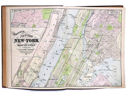
20 hrs LeftJasper521867 Beers Map of New York City Area -- Map of New York and Vicinity Accompanying "Atlas of New YorkUS$200
May 19Chinwe Russell AuctionsForbiden trail of Ragdale By Voytek oil on canvas created with oil on canvas 2024 Artwork SignedUS$5,200
May 19Chinwe Russell AuctionsEarly Morning By Voytek oil on canvas created with oil on canvas 2023 Artwork SignedUS$7,200
1 day LeftDoyle New YorkMarshall's Life of George Washington with an important annotation by James McHenryUS$1,300(1 bid)
6 days LeftGLORY DAYS AUCTION1941 BEVERWYCK IRISH CREAM ALE GAS OIL GARAGE MAN CAVE PORCELAIN SIGNUS$25(1 bid)
May 14Fleischer's Auctions1755 Map Partie de l'Amerique Septentrionale, qui comprend Le Cours de L'Ohio...US$200(3 bids)
May 11Miller & Miller Auctions Ltd.Richardson "World's Fair Selection" Liberty Root Beer SignCA$75(2 bids)
May 18Winfield Auction GalleryAntique German Chrome & Polychromed Foliate & Floral Pottery Beer Keg Tap C1920US$100
May 23Eldred'sJACOB HOFFMAN BREWING CO. ADVERTISING POSTER New York, Late 19th Century Chromolithograph,US$70


![[MAP - TOURS] (1 of 1)](https://p1.liveauctioneers.com/292/326828/175962850_1_x.jpg?height=282&quality=70&version=1713473479)


