Sold2022Authentic large-format 1864 map of Palestine, Johnson &Scarce and informative hand-colored map of Palestine with inset of Jerusalem. If you’ve ever wanted to understand about locations mentioned in the Bible, this would be a great map for you. CreaSee Sold Price
Sold2020Scarce 1864 and 1866 Dripps maps of NYCDetailed and scarce large format 1864 and 1866 maps of New York City and Vicinity by Matthew Dripps, both appearing in Valentine's Manual. The 1864 map covers the entire island of Manhattan as well asSee Sold Price
Sold20201864 Map of PalestineAuthor: Johnson Title: 1864 Map of Palestine Medium: Ink on Paper Dimensions: 14.5"X18" Map of Palestine dated 1864. Engraved by A.J.Johnson. Published by Johnson and Ward in New York. Map key locatedSee Sold Price
Sold20201861 Civil War military map in full hand-colorLarge format, double-page “Johnson’s New Military Map of the United States showing the Forts, Military Posts &c. with Enlarged Plans of Southern Harbors” by Johnson and Ward. Original and vividSee Sold Price
Sold2021Authentic vintage map of Palestine, c1867Title: Authentic vintage map of Palestine, c1867 Description: "From the 1867 edition of Johnson’s New Illustrated Family Atlas. Johnson’s Palestine contains a wealth of information. Along with theSee Sold Price
Sold20201864 Johnson Map of Michigan and Wisconsin -- Johnson'sTitle/Content of Map: 1864 Johnson Map of Michigan and Wisconsin -- Johnson's Michigan and Wisconsin Cartographer: Johnson & Ward Year/Place: 1864, New York Size: 17 X 23 in. This is a large and highlSee Sold Price
Sold20181864 Johnson Map of the United States -- Johnson'sTitle/Content of Map: 1864 Johnson Map of the United States -- Johnson's United States Date: 1864, New York Cartographer: A Johnson Size: 16.9 x 23.1 in. This is a large, highly detailed Civil War eraSee Sold Price
Sold20191864 Johnson Map of Texas -- Johnson's New Map of theTitle/Content of Map: 1864 Johnson Map of Texas -- Johnson's New Map of the State of Texas Date: 1864, New York Cartographer: Johnson & Ward Size: 16.7 X 24.5 in. This a double page, large, quite attrSee Sold Price
Sold20191864 Johnson Map of North and South Carolina --Title/Content of Map: 1864 Johnson Map of North and South Carolina -- Johnson's North and South Carolina Date: 1864, New York Cartographer: Johnson & WardSize: 17.3 x 24 in. An excellent, large, doublSee Sold Price
Sold2016Johnson's Map of Palestine, Inset of Jerusalem, 1864Map: Johnson's Map of Palestine, Inset of Jerusalem Publisher: Johnson and Ward Date: 1864 Size: 14 x 18 inches Please note that this lot has a reserve. When you leave a bid in advance of the auction,See Sold Price
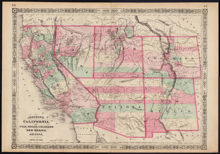
Sold2023Scarce Johnson map of the Great Western states, 1864Authentic vintage map of California, Utah, Nevada, Colorado, New Mexico, and Arizona. Created during a great time of expansion and change in the western United States while the Civil War was still ragSee Sold Price
Sold2021Johnson map of American West – great color, 1864Authentic vintage maps of the American West—especially during the years of constant boundary change--are extremely collectible. Exceptional examples with great color and crisp ink impressions arSee Sold Price
Sold2023Jaillot Map of South America with Exceptional ColorJAILLOT, Alexis Hubert (1632-1712). L'Amerique Meridionale. Engraved map with exceptional original color. Paris, c. 1691. 24 3/4" x 36 1/4" sheet. Large format map of South America, based upon earlierSee Sold Price
Sold2023Extremely scarce and early map of Ohio, M. Carey 1814One of the most influential early maps of Ohio and the first large format map of Ohio to appear in an atlas. This 1816 example is the identical map that appeared in Carey’s 1814 General Atlas.See Sold Price
Sold20191849 India Shewing The Post Roads And Dawk StationsThis remarkably detailed large format map of India and parts of bordering countries highlights the means of transportation in mid-19th century India of both people and goods in the vast region depicteSee Sold Price
Sold2021Very scarce earliest McNally atlas RR mapRand McNally's first large format map of the United States, likely the earliest Rand McNally atlas map. Shows complete railroad network throughout the entire country. Untitled, but "Printed for HistorSee Sold Price
Sold20201813 Pinkerton Map of the Arabian Peninsula and the RedTitle/Content of Map: 1813 Pinkerton Map of the Arabian Peninsula and the Red Sea -- Arabia Date: 1813, London Cartographer: J Pinkerton Size: 20 X 28 in. This is a stunning large format map of the ArSee Sold Price
Sold2022Very scarce 1814 Map of Virginia, Mathew CareyMathew Carey's map of Virginia, one of the best large format maps of the state to appear in a Commercial Atlas. From an extremely scarce 1816 edition of Carey’s General Atlas (the same map as inSee Sold Price
Sold2019Russia.- Jaillot (Alexis-Hubert) La Russie Blanche ouRussia.- Jaillot (Alexis-Hubert) La Russie Blanche ou Moscovie Divisee Suivant l'Estendue Des Royaumes Duches, large format map of Russia, extending from the Baltic and Black Seas to Grande Tartarie aSee Sold Price
Sold20182-pg. Plan of Boston, Mitchell 1872Reserve Reduced! Impressive layout of Boston, hand colored by wards. Highly detailed large format map shows railroad lines, roads, streets, wharfs, bridges, buildings, rivers and other landmarks. ExteSee Sold Price
Sold2022Desirable map of Colorado from huge, scarce McNally atlasOne of the best maps of Colorado to be produced in the 19th century. From Rand, McNally’s 1897 Indexed Atlas of the World, a scarce atlas with beautiful, large format maps. Exquisite detail withSee Sold Price
Sold20241864 Map1864 map "JOHNSON'S UNITED STATES". Sight 17" x 25 1/2", overall 19" x 27".See Sold Price
Sold2017Rand McNally & Co: Map of Brooklyn & Vicinity, 1903Rand McNally & Co’s Map of Brooklyn & Vicinity, 1903. 19 x 26.25 inches. Rand McNally's huge map of Brooklyn is the same as the only large format map of Brooklyn to appear in a general Commercial AtSee Sold Price
Sold2017Colton: Antique Map of Minnesota, 1867Huge 1867 Minnesota map by Colton. Very fine example of this early large format map. Finely engraved map of the state with inset of the north-eastern portion at upper right. Highly detailed with identSee Sold Price
Featured4 days LeftJasper52Johnson's Europe. Navigators' routes. Continental Shelf 1861 old antique mapUS$65
4 days LeftJasper52Johnson's Prussia, Norway, Sweden & Denmark. Scandinavia Baltic Poland 1861 mapUS$85
3 days LeftJasper521864 Johnson Map of Massachusetts, Connecticut and Rhode Island -- Johnson's Massachusetts,US$60
4 days LeftJasper52Spain, Portugal & Western France ports sea chart. Bordeaux Lisbon LARGE 1952 mapUS$35
4 days LeftJasper52Spain, Portugal & Western France ports sea chart. Bay of Biscay. LARGE 1927 mapUS$35
4 days LeftJasper52Spain, Portugal & Western France ports sea chart. Bordeaux Lisbon LARGE 1959 mapUS$60
4 days LeftJasper52Johnson's Sweden, Norway & Denmark with Sleswick & Holstein. Schleswig 1866 mapUS$60
4 days LeftJasper52Johnson's Sweden, Norway & Denmark with Sleswick & Holstein. Schleswig 1865 mapUS$60
4 days LeftJasper52Johnson's Roman Empire. Imperium Romanorum. Graecia Italia Greece Italy 1861 mapUS$160
4 days LeftJasper52Scandinavia physical mountains fjords glaciers. Sweden Norway. STANFORD 1904 mapUS$20
4 days LeftJasper52The Seven United Provinces… Dutch, Austrian & French Netherlands. BOWEN 1789 mapUS$35
4 days LeftJasper52Countries round the Mediterranean. Soundings Telegraph cables. STANFORD 1894 mapUS$75
4 days LeftJasper52Europe Ethnographic map. Breton Basque Flemish Sudtyrol Languages. TIMES 1895US$20