Sold2020Barbados. RARE detailed mapTitle: Barbados. RARE detailed map Date/Period: 1729-1736 Materials: Copperplate engraved Dimensions: 16 1/4 x 12 1/3” By. H. Moll. From. Atlas minor. Published. London. Reserve: $200.00 Shipping:See Sold Price
Sold2018Pacific Ocean.Reserve Reduced! Item: Pacific Ocean. Date: 1841 Cartographer: BOYNTON, GEORGE W., engr. Publisher: S.G. GOODRICH, Size (inches): 13X16.6 no regional divisions. Detailed map from a rare Peter Parley aSee Sold Price
Sold2023Bellin - Map of Philadelphia, PennsylvaniaThis detailed map is from Jacques-Nicolas Bellin's Le Petit Atlas Maritime.... This first edition work was published in Paris by Bellin in 1764. The atlas had included plenty of new material as well aSee Sold Price
Sold2023Bellin - Map of Charleston, South CarolinaThis detailed map is from Jacques-Nicolas Bellin's Le Petit Atlas Maritime.... This first edition work was published in Paris by Bellin in 1764. The atlas had included plenty of new material as well aSee Sold Price
Sold20231850s Dufour ATLAS 42 HUGE MAPS Europe ENORMOUS & RARE Geography Cartography1850s Dufour ATLAS 42 HUGE MAPS Europe ENORMOUS & RARE Geography Cartography Adolphe Dufour was a 19th-century French cartographer and map maker known for his highly detailed maps of European cities aSee Sold Price
Sold2022A RARE 18TH CENTURY MAHOGANY FRAMED LARGE TRIPLE FOLDING SCREEN DEPICTING A DETAILED MAP OF THE CITYA RARE 18TH CENTURY MAHOGANY FRAMED LARGE TRIPLE FOLDING SCREEN DEPICTING A DETAILED MAP OF THE CITY OF LONDON from a bound volume of the Cities of London and Westminster and Southwark and ten-mile raSee Sold Price
Sold2024English map of France French Revolutionary Wars 1796 rare engravingFrance.- French Revolutionary Wars.- Anonymous. A General Map of France Divided into Metropolitan Circles and Departments with the surrounding States, detailed map of France, with parts of Spain, SwitSee Sold Price
Sold2020RARE map of Friesland in the NetherlandsTitle: RARE map of Friesland in the Netherlands Date/Period: 1596 Materials: Copperplate engraved Size: 14" x 10 1/4" Description: One of the new detailed map of the region not made in the Low CountriSee Sold Price
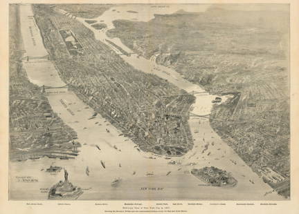
Sold2021New York Bay, 1897Bird’s-Eye View of New York City in 1897This small but intensely detailed map of the city of New York depicts a near snapshot of what could be seen from a rare objective-above. With Burroughs aSee Sold Price
Sold2018Homann Heirs: British Caribbean and Atlantic IslandsDominia Anglorum in praecipuis Insulis Americae On one sheet, five highly detailed maps of British possessions in the Caribbean and Atlantic: St. Kitts, Antigua, Bermuda, Barbados, and Jamaica. St. KiSee Sold Price
Sold20222 PC. FRAMED ANTIQUE MAPS OF ISRAEL2 PC. FRAMED ANTIQUE MAPS OF ISRAEL: Comprising; 1- Detailed Ortelius Map of the Holy Land, Based on Tilemann Stella's Extremely Rare Holy Land Maps. 1- Homann based this map of the Holy Land on the cSee Sold Price
Sold2022THE ATLANTA CAMPAIGN CIVIL WAR MAPTHE ATLANTA CAMPAIGN CIVIL WAR MAP. PLEASE VIEW ALL DETAILED PICTURES. PRINTED TO LOOK LIKE THE ORIGINAL. A GREAT FIND AND AN EXCELLENT ADDITION TO YOUR COLLECTION.See Sold Price
Sold20201889 1ed Cuba’s Fight for Freedom War Spain Beck1889 1ed Cuba’s Fight for Freedom War Spain Beck Battles Cuba Illustrated MAPS “Cuba's fight for freedom, and the war with Spain” is a detailed and highly illustrated description of the 1895-98See Sold Price
Sold20221759 Voyages in CARIBBEAN Jamaica Barbados MAPS Pirates America Slave Trade1759 Voyages in CARIBBEAN Jamaica Barbados MAPS Pirates America Slave Trade The General History of Voyages by abbe Prevost is one of the largest and most impressive collections of stories of expeditioSee Sold Price
Sold20211848 1ed Military Emory Reconnaissance MAPS Indians1848 1ed Military Emory Reconnaissance MAPS Indians California Texas San Diego 39 Engravings, Maps, Views / compare@$7500 Incredible work on westward expedition of William H Emory with detailed illustSee Sold Price
Sold20191848 New York History 59 County Atlas Maps Dutch1848 New York History 59 County Atlas Maps Dutch Colonial Mather ‘A Geographical History of the State of New York’ is a text with detailed sections on the physical features of the state, its naturSee Sold Price
Sold2015A Fine & Rare Map of New York.Bernard Ratzer "Plan of the City of New York". Signed lower right in the plate "T. Kitchin Sculpt" (Kitchin recorded the cartographer's name as Ratzen (sic) rather than Ratzer). The map backed, rolledSee Sold Price
Sold2022Rare map of Chinatown, San Francisco, 1929Heading: -1929 Author: Wong, J.P. Title: Map of San Francisco Chinatown / ????????: ??? / Meiguo Sanfan Shi hua qiao qu: xiang xi tu Place Published: San Francisco Publisher: Date Published:See Sold Price
Sold2021Rare map of private NY sporting reserve 1887Heading: (New York - Tuxedo Park) Author: Bowditch, Ernest W. Title: Tuxedo Park Orange County New York. May, 1887 Place Published: New York Publisher:Endicott & Co. Photo Lith. Date Published: <See Sold Price
Sold2019Rare map of the Bosphorus, 1788Heading: Author: Maire, François Joseph Title: Plan de Constantinople et du Bosphore pour Servir de Renseignement a la Carte des Limites des Trois Empires, ou Theatre de la Guerre Presente Place PubSee Sold Price
Sold2021Rare map of lands beneath Lake Berryessa, Cal.Heading: (California - Napa County) Author: Title: Map of land along the Putah Creek, most of which is now under Lake Berryessa Place Published: No place Publisher: Date Published: Late 19tSee Sold Price
Sold2020RARE map of Cairo, Egypt. With Sphinx and pyramids.Title: RARE map of Cairo, Egypt. With Sphinx and pyramids. c1600 by Matteo Florimi. Siena, Italy Date/Period: c1600 Materials: Copper plate engraved Size: 22 1/2 x 16 1/2 inches. Description: Hand colSee Sold Price
Sold2021Rare map of Oakland with ms. transit lines 1893Heading: (California - Oakland) Author: Dingee, William J. Title: William J. Dingee's Map of Oakland, showing the properties of the Mutual Investment Union. 1893 Place Published: [Oakland?] Publisher:See Sold Price
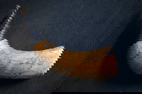
Sold2023Powder Horn with a very detailed map engraved of Northern Illinois and Eastern Iowa. Also hasPowder Horn with a very detailed map engraved of Northern Illinois and Eastern Iowa. Also has Harold Smith engraved in it.See Sold Price
7 days LeftJasper521692 Peeters Map of Southeast France -- Ducatus Saboudiae Principatus Pedemontii ComitatusUS$70
Jun 02Schilb Antiquarian Rare Books1899 STONEWALL JACKSON Civil War Confederate Military + Wolseley PROVENANCEUS$2(2 bids)
3 days LeftTrillium Antique Prints & Rare BooksDavid Roberts - The Hypaethral Temple at Philae, Called the Bed of PharaohUS$200
3 days LeftTrillium Antique Prints & Rare BooksKarl Bodmer - Bison-Dance of the Mandan Indians in front of their Medicine Lodge in Mih-TuttaUS$300
3 days LeftTrillium Antique Prints & Rare BooksKarl Bodmer - The Elkhorn Pyramid on the upper Missouri. 21US$300
6 hrs LeftUniversity ArchivesDeclaration of Independence, Very Early British Publ. in Gentleman's Magazine & Rare MapUS$1,000
1 day LeftPotter & Potter AuctionsGRIDER, Greg. Harley-Davidson Final Assembly Plant York, Pe...US$100
2 days LeftNi-Cola Classics - Automobilia Auction & Classic Car SalesFerrari Original b/w press photo Formula 1 cockpit F 158 fr€150
1 day LeftPotter & Potter AuctionsBOUCHER, Lucien (1889 – 1971). Provence Breguet 763 / Air F...US$300
7 days LeftJasper521764 Bellin Map of Northern Portion of Martinique -- Partie Septentrionale de la MartiniqueUS$45


![Rare map of Oakland with ms. transit lines 1893: Heading: (California - Oakland) Author: Dingee, William J. Title: William J. Dingee's Map of Oakland, showing the properties of the Mutual Investment Union. 1893 Place Published: [Oakland?] Publisher:](https://p1.liveauctioneers.com/642/218849/112379278_1_x.jpg?height=310&quality=70&version=1631923877)