Sold2023Barclay & Findlay 1834 Antique Map. EuropeSteel Engraved Map Published 1834 by Thomas Kelly, London for "A New and Universal English Dictionary" by the Rev. James Barclay. Maps Drawn & Engraved by Alexander Findlay. Paper Size: 10.5 x 8 inchSee Sold Price
Sold2023Barclay & Findlay 1834 Antique Map. AfricaSteel Engraved Map Published 1834 by Thomas Kelly, London for "A New and Universal English Dictionary" by the Rev. James Barclay. Maps Drawn & Engraved by Alexander Findlay. Paper Size: 10.5 x 8 inchSee Sold Price
Sold2023Barclay & Findlay 1834 Antique Map. Spain and PortugalSteel Engraved Map Published 1834 by Thomas Kelly, London for "A New and Universal English Dictionary" by the Rev. James Barclay. Maps Drawn & Engraved by Alexander Findlay. Paper Size: 10.5 x 8 inchSee Sold Price
Sold2021Findlay, Alex C1835 Antique Map. EuropeSteel Engraved Map Published C1835 by Thomas Kelly, London for "A New and Universal English Dictionary" by the Rev. James Barclay. Maps Drawn & Engraved by Alexander Findlay. Paper Size: 10.5 x 8 inchSee Sold Price
Sold2021Findlay, Alex C1835 Antique Map. Russia in EuropeSteel Engraved Map Published C1835 by Thomas Kelly, London for "A New and Universal English Dictionary" by the Rev. James Barclay. Maps Drawn & Engraved by Alexander Findlay. Paper Size: 10.5 x 8 inchSee Sold Price
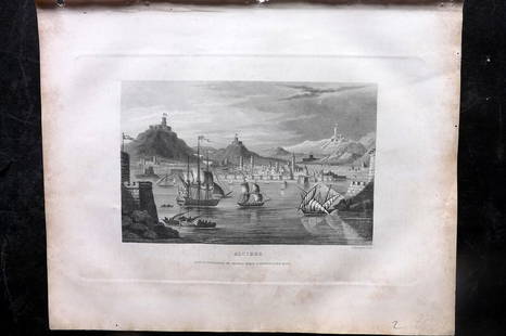
Sold2023Barclay, James 1834 Antique Print. Naples, Italy. ShipsSteel Engraving Published 1834 by Thomas Kelly, London for "A New and Universal English Dictionary" by the Rev. James Barclay. Maps Drawn & Engraved by Alexander Findlay. Paper Size: 10.5 x 8 inch (27See Sold Price
Sold2023Barclay, James 1834 Antique Print. Algiers, Ships, AlgeriaSteel Engraving Published 1834 by Thomas Kelly, London for "A New and Universal English Dictionary" by the Rev. James Barclay. Maps Drawn & Engraved by Alexander Findlay. Paper Size: 10.5 x 8 inch (27See Sold Price
Sold2023Barclay, James 1834 Antique Print. Madrid, SpainSteel Engraving Published 1834 by Thomas Kelly, London for "A New and Universal English Dictionary" by the Rev. James Barclay. Maps Drawn & Engraved by Alexander Findlay. Paper Size: 10.5 x 7 inch (27See Sold Price
Sold2023Barclay, James 1834 Antique Print. Paris, FranceSteel Engraving Published 1834 by Thomas Kelly, London for "A New and Universal English Dictionary" by the Rev. James Barclay. Maps Drawn & Engraved by Alexander Findlay. Paper Size: 10.5 x 8 inch (27See Sold Price
Sold2023Russell & Barclay C1825 Antique Map. EuropeCopper Engraved Map Published C1825., by Fisher & Son, "A Complete Atlas of the World" by John Russell et al. The companion Atlas to "A Complete and Universal English Dictionary" by James Barclay. PapSee Sold Price
Sold2023Barclay, James 1808 Antique Map. EuropeCopper Engraved Map Published 1806, London for "Barclay's Complete and Universal English Dictionary" by the Rev. James Barclay. Paper Size: 10 x 8 inch (26 x 21cm) Margin tear, otherwise Good ConditioSee Sold Price
Sold2023Barclay & Findlay 1834 Lot of 3 Maps. Holland, France and GermanySteel Engraved Map Published 1834 by Thomas Kelly, London for "A New and Universal English Dictionary" by the Rev. James Barclay. Maps Drawn & Engraved by Alexander Findlay. Paper Size: 10.5 x 8 inchSee Sold Price
Sold2024Barclay, James 1808 Antique Map. Russia in EuropeCopper Engraved Map Published 1806-09, London for "Barclay's Complete and Universal English Dictionary" by the Rev. James Barclay. Paper Size: 10 x 8 inch (26 x 21cm) Good ConditionSee Sold Price
Sold2023Barclay & Milton C1810 Antique Map. Russia in EuropeCopper Engraved Map Published C1810, London for "Barclay's Universal Dictionary" by James Barclay. Original outline hand colour. Maps Engraved by W. Milton. Paper Size: 17 x 10.5 inch (43 x 27cm) A coSee Sold Price
Sold2023Barclay, James 1808 Antique Map. Turkey in Europe with Asia MinorCopper Engraved Map Published 1806-09, London for "Barclay's Complete and Universal English Dictionary" by the Rev. James Barclay. Paper Size: 10 x 8 inch (26 x 21cm) Minor toning, otherwise Good CondSee Sold Price
Sold2019Barclay, James 1809 Antique Map. Russia in EuropeOutline Hand Coloured Copper Engraved Map Published 1809, Leeds for "Barclay's Complete and Universal Dictionary of the English Language..." by the Rev. James Barclay. Paper Size: 10 x 8 inch (26 x 20See Sold Price
Sold2024Becker, F. P. C1845 Antique Map. EuropeSteel Engraved Map Published C1845, London for "A Complete and Universal English Dictionary" by the Rev. James Barclay and B. B. Woodward. Maps by F. P. Becker. Outline hand color. Paper Size: 11 x 8See Sold Price
Sold2022Kelly, Christopher 1836 Antique Map. EuropeCopper Engraved Map Published 1836, London for "A New and Complete System of Universal Geography" by Christopher Kelly. Maps Engraved by Findlay, Wallis and others. Paper Size: 10.5 x 8 inch (27 x 20cSee Sold Price
Sold2022Antique Map of Europe - County Map of Glamorganshire - Wales - United KingdomAntique map of Glamorganshire. Place names, topography, roads and railways are shown in significant detail by Joshua Archer. 'The Universal English Dictionary ...' by Rev. James Barclay, published inSee Sold Price
Sold2022Antique Map of Europe - County Map of Huntingdonshire - Wales - United KingdomAntique map of Huntingdonshire. Place names, topography, roads and railways are shown in significant detail by Joshua Archer. 'The Universal English Dictionary ...' by Rev. James Barclay, published inSee Sold Price
Sold2022Antique Map of Europe - County Map of Herefordshire - Wales - United KingdomAntique map of Herefordshire. Place names, topography, roads and railways are shown in significant detail by Joshua Archer. 'The Universal English Dictionary ...' by Rev. James Barclay, published in LSee Sold Price
Sold2021Findlay, Alex C1835 Antique Map. CanadaSteel Engraved Map Published C1835 by Thomas Kelly, London for "A New and Universal English Dictionary" by the Rev. James Barclay. Maps Drawn & Engraved by Alexander Findlay. Paper Size: 10.5 x 8 inchSee Sold Price
Sold2021Findlay, Alex C1835 Antique Map. Mexico & GuatemalaSteel Engraved Map Published C1835 by Thomas Kelly, London for "A New and Universal English Dictionary" by the Rev. James Barclay. Maps Drawn & Engraved by Alexander Findlay. Paper Size: 10.5 x 8 inchSee Sold Price
Sold2021Findlay, Alex C1835 Antique Map. North AmericaSteel Engraved Map Published C1835 by Thomas Kelly, London for "A New and Universal English Dictionary" by the Rev. James Barclay. Maps Drawn & Engraved by Alexander Findlay. Paper Size: 10.5 x 8 inchSee Sold Price
4 days LeftJasper52CAUCASUS. Armenia Georgia Azerbaijan. Iberia Albania Colchis. MALLET 1683 mapUS$50
Featured4 days LeftJasper52Chart of the Sea Coasts of England, Flanders & Holland. MOUNT & PAGE 1758 mapUS$420
Featured4 days LeftJasper52Europe after the Congress of Vienna. 4 sheets. 128x106cm. THOMSON 1817 old mapUS$550
4 days LeftJasper52BLACK SEA. Russia Turkey Crimea Romania Bulgaria Kutais. JOHNSTON 1900 old mapUS$20
4 days LeftJasper52Scandinavia Russia sea chart. Ports lighthouses. Arctic Ocean Bothnia 1918 mapUS$20
Featured4 days LeftJasper52EUROPE. Political. Austro-Hungarian Monarchy. Shipping routes. JOHNSTON 1906 mapUS$20
4 days LeftJasper52WORLD WAR 2. English Channel & North sea ports. German occupied Europe 1942 mapUS$30
4 days LeftJasper52North Sea sea chart. Ports lighthouses mail routes. UK Norway &c LARGE 1952 mapUS$40
4 days LeftJasper52CAUCASUS. 'Georgie Armenie' Georgia Armenia Tblisi Russia. MALLET 1683 old mapUS$100
4 days LeftJasper52Scandinavia Russia sea chart. Ports lighthouses. Arctic Ocean Bothnia 1916 mapUS$20
Featured4 days LeftJasper52SOUTHERN EUROPE & MEDITERRANEAN. inset Gibraltar & Malta. BARTHOLOMEW 1898 mapUS$20
4 days LeftJasper52German invasion of Belgium and France, May-June 1940. World War 2 1953 old mapUS$30
4 days LeftJasper52EUROPE GEOLOGICAL. Quaternary Tertiary Cretaceous Jurassic &c JOHNSTON 1906 mapUS$35
4 days LeftJasper52OTTOMAN EMPIRE in Europe & Asia. Greece. British Ionian Islands. SDUK 1844 mapUS$65
Featured4 days LeftJasper52Il Regno d'Ungaria, Transilvania… Bosnia, Croatia… DE ROSSI / SANSON 1683 mapUS$160
Featured4 days LeftJasper52Pictorial map of the Caucasus. Russia Georgia Azerbaijan Armenia INTOURIST c1932US$850
4 days LeftJasper52Countries embraced within the travels of St Paul. Mediterranean. HUGHES 1856 mapUS$20
4 days LeftJasper52Eastern Europe Italian Albania Czechosolvakia Carpathian Ruthenia TIMES 1922 mapUS$20