Sold2019Mitchell's New General Atlas, 1872Heading: Author: Mitchell, Samuel Augustus Title: Mitchell's New General Atlas, Containing Maps of the Various Countries of the World, Plans of Cities, Etc... Place Published: Philadelphia Publisher:See Sold Price
Sold2019Asher and Adams New Statistical and Topographical AtlasAsher and Adams New Statistical Atlas 1872: Oversize atlas from 1872 by Asher and Adams. Atlas of the US. Light toning and fozing throughout. Early rare atlas in really good condition.See Sold Price
Sold2021Hastings Dobbs’ Ferry Irvington Map Engraving 1872Hastings, Dobbs’ Ferry, Irvington Engraving, 1872, no apparent signature, verso reads ‘(40) Original Map Westchester County Atlas, 1872’, subject maps of the towns of Hastings, Dobbs’ Ferry, aSee Sold Price
Sold2016Atlas of Ohio 1872Heading: Author: Walling, Henry F. and Orlando W. Grey Title: New Topographical Atlas of the State of Ohio with descriptions historical, scientific, and statistical, together with maps of the UnitedSee Sold Price
Sold2021StielerÃs Hand Atlas 5th Ed. 1872 [129903]Formally titled Hand-atlas [x=#252/]ber alle Theile der Erde und [x=#252/]ber das Weltgeb[x=#228/]ude ( Handy atlas of all parts of the world and universe). Considered the leading German world atlas aSee Sold Price
Sold2019Unusual 1872 World map by LloydFrom an 1872 Ohio atlas by H. H. Lloyd comes this unusual hand colored map of the world. With ocean currents, trade winds, monsoons, sargassos, volcanoes and steam ship routes marked. Clean and excellSee Sold Price
Sold2023Asher and Adams. - Maps of New York, Group of 2Lot 45 Asher and Adams. American Manufacturer (1860 - c. 1900) Maps of New York, Group of 2 lithograph with hand coloring Asher and Adams. 1872 New Topographical Atlas and Gazetteer of New York accompSee Sold Price
Sold2018[ATLAS]. OLNEY, Jesse (1798-1872).[ATLAS]. OLNEY, Jesse (1798-1872). A New and Improved School Atlas, to Accompany the Practical System of Modern Geography. New York: Robinson, Pratt & Co, ca 1831. 4to (296 x 240). 12 hand-colored engSee Sold Price
Sold20211872 Morgan County, Illinois Atlas & History Book1872 Morgan County, Illinois Atlas & History Book. (1) Atlas Map of Morgan County Illinois, by Townships, 1872. Measures 17 3/4" x 14 3/4". (1) A History of Lawrence, Kansas: From the First SettlementSee Sold Price
Sold2022Scarce Walling's map of Pacific States andWalling's Atlas Pacific States and Territories, published 1872 by H. H. Lloyd. Scarce and highly informative map shows the states of Oregon, California and Nevada, and the territories of Washington anSee Sold Price
Sold2021State Atlas of New Jersey, Beers Comstock & Cline,State Atlas of New Jersey, Beers Comstock & Cline, 1872, "By and Under the Direction of F.W. Beers, some loss bottom spine, some maps have tears, structurally good.See Sold Price
Sold2022Scarce hand-colored map of California and Nevada (1872)An excellent and quite scarce early map from H. H. Lloyd’s “Atlas of the United States.” Lloyd's Atlas of the United States was never issued as a separate Atlas. Its only appearanceSee Sold Price
Sold2016Warner Beers: Map of Nevada and California, 1872Map: Atlas Map of the United States Map of Nevada and California Maker: Warner Beers Date: 1872 Origin: Chicago, New York Size: 16.3 x 13.5 inches Very nice map of California and Nevada. This was a tiSee Sold Price
Sold2018Plan of Washington, D.C., Mitchell 1872Reserve Reduced! “Plan of the City of Washington the Capitol of the United States of America,” by S. Augustus Mitchell from his 1873 New General Atlas. Nicely centered. Highly detailed and a verySee Sold Price
Sold20191872 Antique Map Historic France in 1483 Louis XI ParisIt is an authentic Antique map with original hand-coloring as issued. It is from M.N. Bouillet's Atlas Universel d'Histoire et de Geographie, published in Paris by the Librairie Hachette, 1872. The naSee Sold Price
Sold2016G.H. SWANSTON MAP OF BRITISH WEST INDIES 1872From The Royal Illustrated Atlas Of Modern Geography, 1862.1st edition 1864; published in 27 parts 1854-62. The date of 1872 is estimated by the Australia map; all the maps are undated and probably daSee Sold Price
Sold2022A grouping of 15 fruit and canning jars including: Five "Mason's Patent Nov. 30th 1858"; sixA grouping of 15 fruit and canning jars including: Five "Mason's Patent Nov. 30th 1858"; six "Mason's Improved" jars; one "The Mason Jar Of 1872"; one "Trade Mark Mason's Improved" jar; one "Atlas MasSee Sold Price
Sold2022Antique Map Print - Map of Bohemia - Map of Czech Republic - KingdomAntique outline hand colored map from edition of Meyer’s world atlas, edited by Ludwig Ravenstein, published by Bibliographic Institute in 1872. Technique: Engraving. Place: Leipzig, Germany. SSee Sold Price
Sold2016Middle States of United States 1829Map Title: Map of the Middle States Maker: Robinson Origin: Atlas Geographicus Date: 1829 Size: 21.25 x 14.25 inches Medium: Engraving From "Olney's School of Geography" Jesse Olney (1798-1872) was aSee Sold Price
Sold2022Original Antique Map -Pommern Provinz - Map of Bornholm Island Baltic SeaAntique outline hand colored map from edition of Meyer’s world atlas, edited by Ludwig Ravenstein, published by Bibliographic Institute in 1872. Technique: Engraving. Place: Leipzig, Germany. SSee Sold Price
Sold2022Original Antique Map - Mecklenburg-Schwerin - Map of Northern GermanyAntique outline hand colored map from edition of Meyer’s world atlas, edited by Ludwig Ravenstein, published by Bibliographic Institute in 1872. Technique: Engraving. Place: Leipzig, Germany. SSee Sold Price
Sold2022Original Antique Map -Bremen Oldenburg - Map of Bremen OldenburgAntique outline hand colored map from edition of Meyer’s world atlas, edited by Ludwig Ravenstein, published by Bibliographic Institute in 1872. Technique: Engraving. Place: Leipzig, Germany. SSee Sold Price
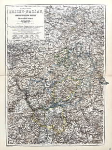
Sold2022Original Antique Map -Hessen Nassau - Map of Furstenthum WaldeckAntique outline hand colored map from edition of Meyer’s world atlas, edited by Ludwig Ravenstein, published by Bibliographic Institute in 1872. Technique: Engraving. Place: Leipzig, Germany. SSee Sold Price
BonhamsMITCHELL (SAMUEL AUGUSTUS) Mitchell's New General Atlas, Containing Maps of the Various Countrie...£500
BonhamsASHER AND ADAMS Asher & Adams' New Historical and Topographical Atlas of the United States. With...£300
5 days LeftJasper52Océanique. Partie… Nle Hollande #51. Queensland NSW coast. VANDERMAELEN 1827 mapUS$320
5 days LeftSwann Auction Galleries(NEW YORK CITY.) Currier & Ives; with Charles Parsons and Lyman Atwater. The Port of New York,US$3,800
6 hrs LeftTony Putty Artifacts7 1/2" Knobbed Crescent. Recovered in 1872. Ex Larry Dyer. Perino COA.US$1,000(1 bid)
3 days LeftBill Hood & Sons Art & Antique AuctionsUS Silver 90% Coin Lot $44.75. 1872 Seated Liberty Dime, 1916 S Barber dime, 225 Mercury DimeUS$475(2 bids)
1 day LeftAustin Auction GalleryGILT & PATINATED-BRONZE FIGURE OF ATLAS SUPPORTING SODALITE SPHEREUS$250(1 bid)
6 hrs LeftHarris Toy and Train AuctionsLionel Postwar O Gauge 1872 Loco and 1872 Tender with 1876 and 1875W Passenger CarsUS$110(2 bids)
6 hrs LeftSimpson Galleries, LLC.AN AMERICAN CIVIL WAR ERA ATLAS, "Johnson's New Illustrated Family Atlas of the World with PhysicalUS$300
Jun 23Schilb Antiquarian Rare Books1957 Atlas Shrugged TRUE 1st printing Ayn Rand Objectivism Dystopian PhilosophyUS$145(7 bids)
Jun 30JM Hobby Supply and Railroad Artifact AuctionsUnion Pacific RR 6-Pack Atlas Hart Ballast Hopper Cars-HO scale-New in BoxUS$30(1 bid)
3 days LeftBill Hood & Sons Art & Antique AuctionsFigure of Atlas Holding Rotating Terrestrial Globe - A composite figure of a gilt Atlas holding aUS$50
Jun 23Schilb Antiquarian Rare Books1872 Revolutionary War 1777 New Jersey Safety Council Symmes Scudder AmericanaUS$8(3 bids)
Jun 30JM Hobby Supply and Railroad Artifact AuctionsThree Burlington Route Atlas Diesel Locomotives-SD45/GP40-N ScaleUS$50(3 bids)
3 days LeftBill Hood & Sons Art & Antique AuctionsTiffany & Co Atlas Desk Clock, with Alarm - Gold tone brass alarm clock by Tiffany & Co. Desk orUS$75(2 bids)


![StielerÃs Hand Atlas 5th Ed. 1872 [129903]: Formally titled Hand-atlas [x=#252/]ber alle Theile der Erde und [x=#252/]ber das Weltgeb[x=#228/]ude ( Handy atlas of all parts of the world and universe). Considered the leading German world atlas a](https://p1.liveauctioneers.com/2699/202326/102449348_1_x.jpg?height=310&quality=70&version=1619652794)


![[ATLAS]. OLNEY, Jesse (1798-1872).: [ATLAS]. OLNEY, Jesse (1798-1872). A New and Improved School Atlas, to Accompany the Practical System of Modern Geography. New York: Robinson, Pratt & Co, ca 1831. 4to (296 x 240). 12 hand-colored eng](https://p1.liveauctioneers.com/197/119933/61100813_1_x.jpg?height=310&quality=70&version=1522758048)