Sold2017Order of the Star of Grand Comoro20th century, gilt metal with green enamel, 60mm wide. First issued by the Sultan of Comoros, an island off Africa's east coast between Mozambique and Madagascar. From the Collection of Esther B. FergSee Sold Price
Sold2021MALAY ARCHIPELAGO/EAST INDIA ISLANDS PhilippinesTITLE/CONTENT OF MAP: 'Malay Archipelago or East India Islands' Vignettes: Victoria Mount - New Guinea; Near Sarawak - Borneo; Natives of New Guinea; The Bee Bear. The map covers the area from Burma aSee Sold Price
Sold2020Maps C1835-1922 Mixed Lot of 9Incl Spain/Portugal, Suffolk, East Indian Islands, Africa, Europe, Central Europe, Mexico, World Political, and Ireland. Examples by Bartholomew, Gross, PZS/Bale & Damielsson, Encyclopaedia BrittannicSee Sold Price
Sold2018Bellin: Antique Map of Somali Coast East Africa, 1750Title/Content of Map: Somali Coast East Africa by Bellin Date Printed: 1750-1760's Cartographer: Jacques Nicholas Bellin Material/Medium: Paper Size: 8 1/2" x 11" Published in Paris. Copperplate engraSee Sold Price
Sold2020Philip, George C1900 Mixed Lot of 8 MapsIncl France, Holland/Belgium, East Indian Archipelago, China/Japan, Africa Physical, Mexico, West Indies/Central America, and South America Physical. Lithograph Maps Published C1900, London for "PhiliSee Sold Price
Sold2021Map showing Marco Polo's travelsHeading: Author: Bowen, Emanuel Title: A Map of Marco Polo's Voyages & Travels in the 13th Century Through a Great Part of Asia, All Tartary, the East India Islands & Part of Africa Place Published:See Sold Price
Sold2023EDWARD VIII COINAGE for the BRITISH EMPIREIncluding: West Africa, East Africa, Kutch India, Jodpur, India, New Guinea, Coronation medals, Falkland Islands, South Africa, Ceylon, Straits Settlement, Fantasy Tower Mint, 1896 Royal Family medal,See Sold Price
Sold2017Bellin Map of West North Africa & Canary Islands, 17501750 Bellin Map of Western North Africa and Canary Islands -- Coste Occidentale D'Afrique. This is Bellin's map of the northwestern coast of Africa. It covers from the Strait of Gibraltar to just beloSee Sold Price
Sold2021A Map of East India Archipelago Chart No. 5, 1871A Map of East India Archipelago Chart No. 5, 1871, Western route to China. Showing Hainan Island, Peninsula of Lein-Chew Mainland China. Eight insets including Hong Kong. Published: James Imray & Son,See Sold Price
Sold20211740 Moll Map of Southeast Africa and Madagascar -- TheTitle: 1740 Moll Map of Southeast Africa and Madagascar -- The South East part of Africa, Containing Zanguebar, Sofala, Sabia, The Island Madagascar & c. Cartographer: H Moll Year / Place: 1740, LondoSee Sold Price
Sold2021Bellin: West Coast of Africa with St. Helena IslandTitle/Content of Map: Bellin: West Coast of Africa with St. Helena Island Date Printed: 1739/1760, Paris Cartographer: Bellin Size: 10 1/4" x 9 1/2" Additional Info: Bellin's map of the west coast ofSee Sold Price
Sold2023T. Yoshida Woodblock - Morning Mist in East AfricaArtist: Yoshida, Toshi, 1911-1995 Title: Morning Mist in East Africa Date: 1991 Medium: woodblock Image Size: 10 5/8 x 23 1/2 inches Notes: Pencil signatureSee Sold Price
Sold2023Toshi Yoshida Woodblock - Evening in East AfricaArtist: Yoshida, Toshi, 1911-1995 Title: Evening in East Africa Edition: 62/600 Date: 1977 Medium: Japanese woodblock print Image Size: 11 7/8 x 19 3/4 inches <See Sold Price
Sold2021Toshi Yoshida Woodblock - One Day in East Africa No. 9Artist: Yoshida, Toshi, 1911-1995 Title: One Day in East Africa No. 9 Edition: 979/1000 Date: 1983 Medium: Japanese woodblock print Image Size: 10 1/2 x 23 1/2 inchesSee Sold Price
Sold2018Ortelius: Antique Map of Ethipoia & East Africa, 1592Title/Content of Map: Ethipoia & East Africa. The Prester John Map by Ortelius Date Printed: 1592 Cartographer: Abraham Ortelius Material/Medium: Paper Size: 16" x 21" Hand colored copperplate engraveSee Sold Price
Sold2017Snuff Gourd, East AfricaAn exceptionally well-carved Tanazanian snuff gourd made from wood and bamboo. The finial is beautifully carved and the bottle has a fine, old patina. Dates to late 19th/early 20th century. Height isSee Sold Price
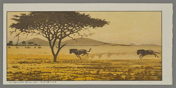
Sold2023Toshi Yoshida Woodblock - One Day in East Africa #2Artist: Yoshida, Toshi, 1911-1995 Title: One Day in East Africa No. 2 Edition: 558/1000 Series: Raised Seal Edition Date: 1991 Medium: Japanese woodblock printSee Sold Price
Sold2022Authentic African Masai Lion Spear From East AfricaThis Spear is very old. Around 1910 give or take a couple of years. It measures 7 feet 2" long, which is just about the same height as a Masai Warrior. Back at the time of this Spear, the Masai were sSee Sold Price
Sold2021Toshi Yoshida Woodblock - One Day in East Africa No. 7Artist: Yoshida, Toshi, 1911-1995 Title: One Day in East Africa No. 7 Edition: 595/1000 Date: 1982 Medium: woodblock Image Size: 10 1/2 x 23 1/2 inches NotesSee Sold Price
Sold2019GIA Cert. 4.02 ct. Untreated Tsavorite Garnet - KENYAGIA Certified 4.02 ct. Tsavorite (Grossularite - Garnet) - Untreated - KENYA, EAST AFRICA Cut - Oval Modified Brilliant Cut Color - Green Clarity - VS Ct. Weight - 4.02 ct. See Sold Price
Sold2023Lotus Certified Natural Tsavorite Garnet 6.08 Cts Rich Green Cushion CutGemstone: Natural Tsavorite ( Green Garnet ) Shape/cut: Antique Cushion Weight: 6.08 Cts. Measurements: 11.12 x 8.82 x 6.67 mm Color: Rich Green Origin: East Africa Pieces: 1 Treatment: No IndicationsSee Sold Price
Sold2022Kuhnert, Wilhelm (Antilope). Ost-Afrika, 21.7.1905. Graphit auf Papier. Blattmaße 24 x 33,5 cm.Zoologica Specifica Kuhnert, Wilhelm (Antilope). Ost-Afrika, 21.7.1905. Graphit auf Papier. Blattmaße 24 x 33,5 cm. Signiert, datiert und lokalisiert. (Antelope). East Africa, 21.7.1905. GraphiteSee Sold Price
Sold2017African Spears, Walking Canes, Bows & Arrows.Primitive African Weapons Spears, Walking Canes, Bows & Arrows. c. 20th Century. Bodonge, Belgian Congo, Mangbetu, Zaire, East Africa. All handmade and hand forged weapons. Ceremonial Axes originallySee Sold Price
Sold2022Iraqw Beaded Skirt, 20th C, Tanzania.A Iraqw Beaded Skirt. Beads, natural fibers, and animal hide. North central Tanzania, East Africa. Frame: 61 5/8" x 38 3/4". Iraqw skirts are amongst the most elaborately decorated textiles from easteSee Sold Price
5 days LeftJasper52Coste d’Afrique…' Guinea-Bissau & Bissagos archipelago. BELLIN/SCHLEY 1747 mapUS$25
5 days LeftJasper52Coste d’Afrique…' Guinea-Bissau & Bissagos archipelago. BELLIN 1746 old mapUS$25
Featured5 days LeftJasper52Coste Orientale d’Afrique…' East Africa Kenya Tanzania Somalia. BELLIN 1746 mapUS$80
5 days LeftJasper52Coste Orientale d’Afrique…' South Africa. Mozambique channel. BELLIN 1746 mapUS$25
5 days LeftJasper52Coste Orientale d’Afrique'. South Africa Mozambique BELLIN/SCHLEY 1747 mapUS$25
Jun 08Leon GalleryAbraham Ortelius (1527 - 1598) - Indiae Orientalis (Philippines/China/ India/ Southeast Asia)₱200,000
20 hrs LeftTrillium Antique Prints & Rare BooksPrevost - Chart of the Islands of Java, Sumatra, Borneo, &c.US$50
5 days LeftJasper52Coste Occidentale d’Afrique…' West Africa. Gulf of Guinea. BELLIN 1746 mapUS$55
20 hrs LeftTrillium Antique Prints & Rare BooksPrevost - Pair of Engravings of Santo Domingo or HispaniolaUS$50
20 hrs LeftTrillium Antique Prints & Rare BooksPrevost - 3 Natural History Engravings of Avocado, Passion Flower, Aloe, Flying Squirrel, & LizardUS$50
5 days LeftJasper52SOUTHERN AFRICA. Congo British/Portuguese/German East Africa Rhodesia 1912 mapUS$30
BonhamsEAST AFRICA DE WIT (FREDERICK) Occidentalior Tractus Indiarum Orientalium a Promontorio Bonae Sp...£300