Sold2021Eleven Antique Maps of EuropeEleven Antique Maps of Europe , 16th-18th c., incl. Ptolemy from 1541 (4); a Blaeu map of "Regno di Napoli", Hondius map of the Holy Land, de Wit map of Southern Spain, an undated manuscript map of MeSee Sold Price
Sold2017Map, holy land, Palestine, by Abraham Ortelius, 1612Early map, Palestine, holy land, by Abraham Ortelius, published in Antwerp, 1612, 14.5" by 18.5"See Sold Price
Sold2022MAP, Holy Land, JanssonHoly Land. Jan Jansson, Tabula Itineraria Patriarcharum Abrahami, Isaaci et Iacobi, from Accuratissima Orbis Antiqui Delineatio…, 1657 (published). Hand Color. A fine decorative map illustrating theSee Sold Price
Sold2019MAP - Holy Land. Mercator/HondiusHoly Land. Mercator/Hondius, Peregrinatio Israelitaru in Deserto, 1610 (published). Hand Color. A handsome small map depicting the Exodus and the wandering of the Children of Israel. An inset of the ESee Sold Price
Sold20151812 Hand Colored Map Holy landHandcolored map of the “Tribe of Manasseh” in the Holy land , printed by Mathews and Leigh, 1812. Measures 11 x 9”.See Sold Price
Sold2024Marmocchi, F. C. 1845 Hand Col Map. Holy Land. Canaan. Israel PalestineFolio Hand Colored Etching/Engraving Published 1845, Florence for "Atlante di Geografia-Storica Universale" by Francesco C. Marmocchi. Paper Size: 17 x 11 inch (43 x 28cm) Good ConditionSee Sold Price
Sold2024Marmocchi, F. C. 1845 Hand Col Map. Holy Land. Persia Empire, Alexander the GreatFolio Hand Colored Etching/Engraving Published 1845, Florence for "Atlante di Geografia-Storica Universale" by Francesco C. Marmocchi. Paper Size: 17 x 11 inch (43 x 28cm) Good ConditionSee Sold Price
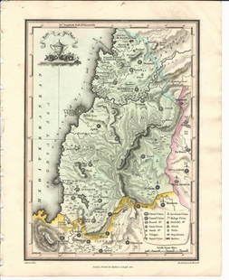
Sold2024Marmocchi, F. C. 1845 Hand Col Map. Holy Land. Israel, Jerusalem insetFolio Hand Colored Etching/Engraving Published 1845, Florence for "Atlante di Geografia-Storica Universale" by Francesco C. Marmocchi. Paper Size: 17 x 11 inch (43 x 28cm) Good ConditionSee Sold Price
Sold20241871 Holy BIBLE & MAPS Holy Land Hitchcock Analysis Gruden Concordance Theology1871 Holy BIBLE & MAPS Holy Land Hitchcock Analysis Gruden Concordance Theology A rare, 19th-century book of systematic theology published by Johnson in New York. This edition of Hitchcocks Complete ASee Sold Price
Sold20241872 Holy BIBLE & Hitchcock Analysis Gruden Concordance Theology MAPS Holy Land1872 Holy BIBLE & Hitchcock Analysis Gruden Concordance Theology MAPS Holy Land A rare, 19th-century book of systematic theology published by the Johnson in New York. This edition of Hitchcocks CompleSee Sold Price
Sold2019Holy land, Jordan and CyprusTitle/Content of Map: Holy land, Jordan and Cyprus Date: 1598/99 Cartographer: By Ruscelli Size: 11x9” Provenance: Venice Reserve: $225.00 Shipping: Domestic: Free shipping to anywhere within the coSee Sold Price
2018Seutter: Antique Map of Holy Land, 1740Title/Content of Map: Holy Land by Sutter Date Printed: c1740 Cartographer: Matthaus Seutter Material/Medium: Paper Size: 24" x 19 1/2" Original hand colored Copperplate engraved. Published in AugsburSee Sold Price
Sold2023Antique Map of Holy Land Palestine Map, Israel Twelve Tribes Jerusalem 1833 Lapie Large Folio MapAntique Holy Land Palestine Israel Twelve Tribes Jerusalem Antique 1833 Lapie Large Folio MapAntique Holy Land Palestine Israel Twelve Tribes Jerusalem 1833 Lapie Large Folio Map. Carte de la PalestinSee Sold Price
Sold2019MAP - Jerusalem, Holy Land. DanckertsJerusalem, Holy Land. Cornelius Danckerts, De Stadt Ierusalem, 1718 (published). Hand Color. Great bird's-eye plan of the ancient holy city flanked by engravings of religious icons. At the bottom areSee Sold Price
Sold2017von Adrichom: Antique Map of Holy Land / Naphtali, 1584Map: Tribus Neptalim Cartographer: von Adrichom Place & Date: Cologne / 1584 Size: 14 1/2" x 8 1/4" Condition: colored cartouche, town icons and topographical details; overall age toning A map of theSee Sold Price
Sold20221889 LARGE WALL MAP of HOLY LAND to ILLUSTRATE BIBLE antique 52 by 60" antiqueLarge Wall Map of The Holy Land to Illustrate both the Old and New Testaments. Size 60 x 52 inches linen-backed and lacquered, wooden rollers; margins chipped, some soiling, generally sound. Made in ESee Sold Price
Sold20221550 Munster Map of Holy Land and Cyprus -- [Holy Land and Cyprus]Title: 1550 Munster Map of Holy Land and Cyprus -- [Holy Land and Cyprus] Cartographer: S Munster Year / Place: 1550, Basel Map Dimension (in.): 10.8 X 6.7 in. This a superb woodblock map of the HolySee Sold Price
Sold2016Bown map of Holy Land 1747Heading: Author: Bowen, Emanuel Title: An Accurate Map of the Holy Land Divided into the XII Tribes of Israel. Accomodated to Sacred History, & describing the Travels of Jesus Christ Place Published:See Sold Price
Sold2017de la Rue: Antique Map of Holy Land, 1730Map: Regnum Iudeorum in Filios Herodis Magni per Tatrarchias Divisum Cartographer: Philippe de la Rue / Covens & Mortier Place & Date: Amsterdam / 1730 Size: 18 1/2" x 15 1/2" Condition: old color; ovSee Sold Price
Sold2018Le Rouge: Antique Map of Holy Land, 1746Title/Content of Map: La Palestine ou la Terre Sainte divisee en dix tribus Cartographer: le Rouge Place & Date: Paris / 1746 Size: 8 1/8" x 11" Condition: Outline color; light overall age toning andSee Sold Price
Sold2017Martier: Antique Map of Holy Land, Jerusalem, 1705Map: Ancient Holy Land Patriarchy of Jerusalem Date Printed: 1705-06 Cartographer: Pierre Martier Material/Medium: Paper Size: 23 1/2" x 19 1/2" Condition: Excellent Original hand coloring. CopperplatSee Sold Price
Sold2017Martier: Antique Map of Holy Land Divisions, 1705Map: Ancient Holy Land Divisions of the Patriarchy of Jerusalem Date Printed: 1705-06 Cartographer: Pierre Martier Material/Medium: Paper Size: 23 1/2" x 17" Condition: Excellent Original hand colorinSee Sold Price
Sold20151812 Hand Colored Map of Holy landHand colored map of the “Tribe of Asher” in the Holy land , printed by Mathews and Leigh, 1812. Measures 9 x 11”.See Sold Price
Sold20151812 Handcolored Map of Holy LandHand colored map of the “Tribe of Gad” in the Holy land , printed by Mathews and Leigh, 1812. Measures 11 x 9”.See Sold Price
BonhamsBLAEU (WILLEM AND JAN) Toonneel des Aerdrycz, oft Nieuwe Atlas... Tweede Deels, 2 parts in 1 vol...£8,000
Jun 23Schilb Antiquarian Rare Books1790 Life of Jesus Christ Fleetwood Bible ART Miracles Jerusalem MAP Holy LandUS$105(5 bids)
BonhamsSPILSBURY (FRANCIS B.) Picturesque Scenery in the Holy Land and Syria, FIRST EDITION, Edward Orm...£600(1 bid)
1 day LeftTrillium Antique Prints & Rare BooksDavid Roberts - View Under the Grand Portico, PhilaeUS$200(1 bid)
1 day LeftTrillium Antique Prints & Rare BooksDavid Roberts - General View of the Island of Philae, NubiaUS$200
1 day LeftTrillium Antique Prints & Rare BooksDavid Roberts - The Acropolis, Lower End of the ValleyUS$200
Jun 22Trillium Antique Prints & Rare BooksDavid Roberts - The Great Temple of Aboo Simble, NubiaUS$200
Jun 22Trillium Antique Prints & Rare BooksDavid Roberts, RSE - Slave Boat on the Nile, View Looking Towards the Pyramids of Dashour andUS$500
2 days LeftPalmyra Heritage GalleryANCIENT Holy Land Iron Age Terracotta Jug ca. 1000 BC.US$125(4 bids)
2 days LeftPalmyra Heritage GalleryAncient Holy Land Iron Age Terracotta Hedgehog c.900-700 BC.US$50(2 bids)
Jul 14Schilb Antiquarian Rare Books1836 Holy Land 1ed Syria & Turkey Arabic Ruins Damascus ConstantinopleUS$1(1 bid)
1 day LeftCosta Blanca Auctions SLHand Grenade, Medieval Near East, Holy Land, Byzantine Empire, ca. 9th to 11th century CE.€700
1 day LeftCosta Blanca Auctions SLHand Grenade, Medieval Near East, Holy Land, Byzantine Empire, ca. 9th to 11th century CE.€700
1 day LeftCosta Blanca Auctions SLHand Grenade, Medieval Near East, Holy Land, Byzantine Empire, ca. 9th to 11th century CE.€700


![1550 Munster Map of Holy Land and Cyprus -- [Holy Land and Cyprus]: Title: 1550 Munster Map of Holy Land and Cyprus -- [Holy Land and Cyprus] Cartographer: S Munster Year / Place: 1550, Basel Map Dimension (in.): 10.8 X 6.7 in. This a superb woodblock map of the Holy](https://p1.liveauctioneers.com/5584/265564/138674312_1_x.jpg?height=310&quality=70&version=1666735666)