Sold2023Buffon & Vaugondy 1830 Map of the Old World"Carte de L'Ancien Continent" Lithograph Published 1828-33, Brussels for "Oeuvres completes de Buffon" by the Comte de Buffon and Louis-Jean-Marie Daubenton. Folds as issued. Paper Size: 12 x 10 inchSee Sold Price
Sold2023Buffon & Vaugondy 1830 Map of America"Carte du Nouveau Continent" Lithograph Published 1828-33, Brussels for "Oeuvres completes de Buffon" by the Comte de Buffon and Louis-Jean-Marie Daubenton. Folds as issued. Paper Size: 12 x 10 inch (See Sold Price
Sold2020Framed Antique Map Orbis Vetus, Robert De VaugondyItem/Description: Old print. Map of the world by Robert de Vaugondy from 1752. Orbis vetus in utraque continente : In both the old continent / world map / Vaugondy 1752. Material: Print framed under gSee Sold Price
Sold2020Buffon & Vaugondy 1791 Map of Africa Continent"Map of the Old Continent" Copper Engraved Map Published 1791, London for "Natural History, General and Particular" by the Comte de Buffon. Translated by William Smellie. Engraved A. Bell after RobertSee Sold Price
Sold2023MAP, Africa, Robert de VaugondyAfrica. Gilles Robert de Vaugondy, L'Afrique Divisee en ses Principaux Empires et Royaumes par les Srs. Sanson..., 1749 (dated). Hand Color. Gilles Robert de Vaugondy succeeded his uncle, Pierre MoulaSee Sold Price
Sold2023MAP, Western Hemisphere, Robert de VaugondyWestern Hemisphere - America. Didier Robert de Vaugondy, L'Amerique, from Nouvel Atlas Portatif, 1778 (circa). Hand Color. This handsome small map of the Americas is sparsely detailed, but interestingSee Sold Price
Sold2024Buffon, Vaugody & Bell 1785 Map of the Old Continent. Africa, AsiaEngraved A. Bell, based on Vaugondy's earlier Map. Copper Plate Published 1785, London for "Natural History, General and Particular" by the Count de Buffon. Translated by William Smellie Folds as issuSee Sold Price
Sold2023Calmet, Augustin 1732 Large Map. Old World according to Noah's Sons"A Geographical Map of the Old World according to the division of it among Noah's Sons" Folio Copper Plate Published 1732, London for "An Historical, Critical, Geographical, Chronological and EtymologSee Sold Price
Sold2020Buffon & Vaugondy 1791 Map of America Continent"Map of the New Continent" Copper Engraved Map Published 1791, London for "Natural History, General and Particular" by the Comte de Buffon. Translated by William Smellie. Engraved A. Bell after RobertSee Sold Price
Sold2022Brewster, David 1830 Antique Map. World on Mercator's Projection"Charte of the World on Mercator's Projection with the dip and variation of the Compass. The Trade Winds & Monsoons" Copper Engraved Map Published 1808-1830, Edinburgh for "The Edinburgh EncyclopaediaSee Sold Price
Sold2023Buffon & Vaugondy 1825 Map. America - Carte du Nouveau ContinentCopper Engraved Map Published 1825 (Map dated 1749) Paris for "Oeuvres Completes De Buffon" by the Comte de Buffon and Bernard Lacepede. Maps by Robert de Vaugondy. Folds as issued. Paper Size: 12 x 8See Sold Price
Sold2022Cellarius & Patrick 1816 Map. Hemisphere, Old WorldCopper Engraved Map Published 1816, London for "Geographia Antiqua" by Samuel Patrick. Maps based on those by Andreas Cellarius. Folds as issued. Paper Size: 10 x 8 inch (26 x 20cm) Good ConditionSee Sold Price
Sold2022Brewster, David 1830 Antique Map. World HemipsheresCopper Engraved Map Published 1808-1830, Edinburgh for "The Edinburgh Encyclopaedia" Conducted by David Brewster. Folds as issued. Paper Size: 17 x 10.5 inch (43 x 27cm) Very minor background toning/oSee Sold Price
Sold2023Buffon & Vaugondy 1825 Map. Africa - Carte de L'Ancien ContinentCopper Engraved Map Published 1825, Paris for "Oeuvres Completes De Buffon" by the Comte de Buffon and Bernard Lacepede. Maps by Robert de Vaugondy. Folds as issued. Paper Size: 12 x 9 inch (30 x 23cmSee Sold Price
Sold2023America. North/South Americas. California Missions. THOMSON 1830 old mapTITLE/CONTENT OF MAP: 'America' DATE PRINTED: 1830 IMAGE SIZE: Approx 53.0 x 64.0cm, 20.75 x 25.25 inches (Large); Please note that this is a folding map. TYPE: Antique early 19th century atlas map wiSee Sold Price
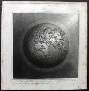
Sold2019Rhind, William 1844 Rare Map of the Old World. EarthAquatint Map Published 1844, London "The Creation: Illustrated By Six Engravings On Steel" by William Graeme Rhind. Rare. Paper Size: 6.5 x 6 inch (16.5 x 16cm) Very minor margin toning, slightly affeSee Sold Price
Sold2022Egypt. Nile Valley. Eyles Irwin's 1777 route from India. THOMSON 1830 old mapTITLE/CONTENT OF MAP: 'Egypt' The map is noteworthy for showing the return route of Eyles Irwin, an Irish poet and civil servant, through Egypt from India, where he been in the service of the East IndSee Sold Price
Sold2022Framed Needlepoint Old World Map Antique needlepoint of the world featuring the oceans and nauticalAntique needlepoint of the world featuring the oceans and nautical references.Framed 20.5" x 20"STERLING ASSOCIATES STRIVES TO PROVIDE ACCURATE, OBJECTIVE, & FAIR INFORMATION ON ALL LOTS. WE WILL BE HSee Sold Price
Sold20221814 map of the Old World, WilkinsonExcellent map of the Old World titled “Terra Veteribus Nota” (Land of the Old) from An Atlas Of Ten Select Maps Of Ancient Geography Both Sacred And Profane; With A Chronological Table OfSee Sold Price
Sold2024Paint Decorated Old World Map BoxPaint Decorated Old World Map Box. 23 3/4" W 12" D 12" H ALL DESCRIPTIONS AND ANY CONDITION STATEMENT GIVEN BY LANGSTON AUCTION GALLERY ARE STRICTLY OPINIONS AND LANGSTON'S SHALL HAVE NO RESPONSIBILITSee Sold Price
Sold2019Embossed Leather Decanter w Old World Map DesignEmbossed Leather Decanter w Old World Map Design. Measures 10 inches in height.See Sold Price
Sold2023A Grouping of 17th & 18th Century Old World Maps Lot of 6Lot Includes: The English Channel, A Map of France, North American Rivers and Lakes Between Superior and Slave Lake (2), A New map of Russia in Europe, & Nouvelle Carte Du Royaume de Bengale EngraSee Sold Price
Sold20166 PC VINTAGE MID CENTURY BARWARE, OLD WORLD MAP DESIGN,6 PC VINTAGE MID CENTURY BARWARE, OLD WORLD MAP DESIGN, INCLUDES PITCHER APPROX 8"H, 4 GLASSES APPROX 3.25"H, & WOODEN TRAY APPROX 12" X 8.5"See Sold Price
3 hrs LeftJasper52Carte de la Scandinavie… Scandinavia Sweden Norway Denmark. LAPIE 1830 old mapUS$45
2 days LeftRoyal Treasures Warehouse LLC1530s Old Map of the World as seen from the North & South PolesUS$100
3 hrs LeftJasper52German invasion of Belgium and France, May-June 1940. World War 2 1953 old mapUS$30
3 hrs LeftJasper52CENTRAL EUROPE. 1914-1920 border changes due to First World War 1 1920 old mapUS$20
7 days LeftThomaston Place Auction GalleriesCOLLECTION OF TRAVEL EPHEMERA, BROCHURES, BOOKLETS, MAPS 1900-1950US$100
18 hrs LeftPotter & Potter AuctionsFLACHMAN, Chuck. Being a Map of Saint Louis / Home of Anheu...US$100
May 30NY Elizabeth 1792 OLD INDIA HISTORY ANTIQUE ILLUSTRATED WITH MAPS OF THE EIGHTEENTH CENTURY IN FRENCHUS$50