Sold2018Cambodia-Laos-Vietnam Physical and Road MapTitle: Cambodia-Laos-Vietnam Physical and Road Map Publication Date: 10/1/1962 Cartographer: ARMY MAP SERVICE, CORPS OF ENGINEERS Publisher: ARMY MAP SERVICE Size: 32.25X23.25 "Refer to this map as CaSee Sold Price
Sold2023Original Vintage Indochine Francaise Map by Lucien Boucher 1935 Vietnam Laos CambodiaAs one can only imagine, travel in the Far East in the 1920's must have been a challenging adventure. This well illustrated map poster by master artist, Lucien Boucher shows the various routes once coSee Sold Price
Sold2019India into south east Asia. Shows Thailand, Laos,Title/Content of Map: India into south east Asia. Shows Thailand, Laos, Cambodia, Vietnam Burma, Malaysia, Nepal , Bhutan Date: 1861 Cartographer: Johnson Material/Medium: steel engraved Size: 18x14��See Sold Price
SoldCambodia, Laos, Vietnam Une Piastre Banknote, UNCirculatedCambodia, Laos, Vietnam Une Piastre Banknote, UNCirculatedSee Sold Price
Sold2017Two Full Stamp Albums from Cambodia, Laos and Vietnam,Two Full Stamp Albums from Cambodia, Laos and Vietnam, Appear to be mint.See Sold Price
Sold2021S.E. Asia, Thailand, Vietnam, Cambodia, Laos,Title: S.E. Asia, Thailand, Vietnam, Cambodia, Laos, Philippines. by Bonne/ Raynal 1780 Date/Period: 1780 Materials: Copperplate engraved Size: 13 1/2 x 9 3/4'' An area of the world not covered in detSee Sold Price
Sold2023COLLECTION OF ASIAN STAMPS.Twentieth century. Includes stamps, first day issues, and envelopes from Vietnam, Laos, Cambodia and more. Some canceled.See Sold Price
Sold2019Southeast Asian Banded VesselSoutheast Asian style refers to visual and cultural arts produced in Southeast Asian countries, including Myanmar (Burma), Thailand, Laos, Cambodia, Vietnam, Malaysia, Singapore, Indonesia, and the PhSee Sold Price
Sold2023Continental Part of Southeast Asia. Thailand, Laos, Cambodia, Burma Vietnam and Malay Peninsula. ByTitle: Continental Part of Southeast Asia. Thailand, Laos, Cambodia, Burma Vietnam and Malay Peninsula. By A. Perrot Date: 1837 Materials: Hand-colored steel engraving Dimensions: 7 x 10 3/4” DeSee Sold Price
Sold20241775-1780 South East Asia. Vietnam, Philippines, Thailand, Cambodia, Laos , Taiwan by Bonne & RaynalTitle: 1775-1780 South East Asia. Vietnam, Philippines, Thailand, Cambodia, Laos , Taiwan by Bonne & Raynal Date/Period: 1775-1780 Materials: Copperplate engraved Size: 14 1/2” x 9 1/2 “ TSee Sold Price
Sold2018Bellin: Antique Map of Southeast Asia, 1740Title/Content of Map: Burma, Thailand, Cambodia, Laos & Vietnam Date Printed: 1740-70's Cartographer: J.N. Bellin & J.F. La Harpe Material/Medium: Paper Size: 11 1/2" x 12 1/2" Copperplate engraved. FSee Sold Price
Sold2023FRENCH INDOCHINA Indochine. South Laos & Annam. Vietnam. Hue city plan 1929 mapTitle: FRENCH INDOCHINA Indochine. South Laos & Annam. Vietnam. Hue city plan 1929 map Description: Laos et Annam - Politique (sud). Inset: Hue' by Commandant P. Pollacchi (1929). Vintage atlas map, 3See Sold Price
Sold2023FRENCH INDOCHINA Indochine. South Laos & Annam. Vietnam. Hue city plan 1931 mapLaos et Annam - Politique (sud). Inset: Hue' by Commandant P. Pollacchi (1931). Vintage atlas map, 36.0 x 25.0cm, 14 x 9.75 inches Details: TITLE/CONTENT OF MAP: 'Laos et Annam - Politique (sud). InseSee Sold Price
Sold2017MAP, C. 1750, INDIA & SOUTHEAST ASIA, ISAAK TIRIONFramed map of India an nearby countries, "Nieuwe Kaart van India over de Ganges of van Malakka, Siam, Cambodia, Chiampa, Kochinchina, Laos, Pegu, Ava" c. 1750 by Issak Tirion (Dutch, 1705-1765), handSee Sold Price
Sold2024Keith Haring Artwork Signed on a Shell Oil New York Road Map 18 in. x 24 in.Keith Haring Artwork Signed on a Shell Oil New York Road Map 18 in. x 24 in. size: 18 x 42 open - rippingSee Sold Price
Sold2022HUSKY GASOLINE SERVICE STATION MAP DISPLAY W/ HUSKY ROAD MAPS.SST. An excellent and complete example of this Circa 1950's Service Station Road Map Display from Husky showing a Tin Husky Sign at the face and complete with Maps. CONDITION: Display is in overall exSee Sold Price
Sold2022New road map of the city of Paris 1839 Rosselin editeur engravingNouveau plan routier de la ville de Paris, Guide exacte de cette capitale : en 12 arrondissemens avec leurs mairies et en 48 quartiers, 1839V. ROSSELIN (19th century), print editor, Paris, EstablishedSee Sold Price
Sold2022British road maps.- Ogilby (John) The Roads fromNO RESERVE British road maps.- Ogilby (John) The Roads from Chelmsford in Essex to St. Edmonds-Bury in Suffolk & Saffron-Walden in Essex, strip road map, engraving with hand-colouring, on thin laid paSee Sold Price
Sold2021Rare Tai Wedding Blanket, Laos/Vietnam, circa 1900A rare Tai wedding blanket with center woven silk and cotton in compound weft-faced weave, bordered in cotton cloth, Laos/Vietnam, circa 1900. Size: 64'' x 44'', 163 x 112 cm (base); 43'' x 25'', 109See Sold Price
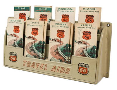
Sold2023Vintage Phillips 66 Road Map Embossed Display RackVintage Phillips 66 embossed plastic road map display rack full with original 1930s Phillips 66 maps. Rack has discoloration, some expected chips/ cracks, and wear from use and age. Displays well withSee Sold Price
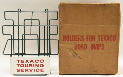
Sold2021Vintage NOS Texaco Road Map Metal Display RackVintage new old stock Texaco road map metal display rack in original box. Nice condition with light wear from age and storage. Display rack measures approximately 10-1/2" tall by 9" across.See Sold Price
Sold2020Road map of Southern California 1918Heading: (California) Author: Title: Automobile Road Map of Los Angeles, Orange, Riverside and San Bernardino Counties Place Published: Los Angeles Publisher:Security Trust & Savings Bank Date PSee Sold Price
Sold2018Auto road map of greater Los Angeles, 1916Heading: (California - Southern) Author: Parker, O.K. Title: Automobile Road Map of Los Angeles, Orange, Riverside and San Bernardino Counties Place Published: Los Angeles Publisher:Security Trust & SSee Sold Price
2 hrs LeftThe Bidder AuctionsUncommon! Map of transportation routes of Palestine - Survey of Palestine Motor Map, 1935 Road mapUS$30
Jun 09Worthington Galleries19th c. Hemisphere World Map, Hohen und Tiefen der Erde in Lambert’s Zenithal-Projection vonUS$10
5 hrs LeftRapid Estate Liquidators and Auction Gallery6 1980s 1990s 2000s National Geographic Magazines NGIUS$25
Jun 23Schilb Antiquarian Rare Books1890 Livingstone 1ed In Darkest Africa Henry Stanley Emin Pasha Expedition MAPUS$28(6 bids)
Jun 08Early American History Auctions1853 Specialized Map, Railroads in the United States in Operation and Progress... Treasury DeptmentUS$200(1 bid)
5 days LeftJasper521893 Civil War Map of Siege of Yorktown, Battle of Siloh and Army of Ohio Operations -- Plan ofUS$55