Sold2016Chart of California Coasts 1856Heading: Author: Robiquet, Aime Title: Carte des côtes de Californie de Mazatlan à San Francisco d'apres les derniers travaux Américains par Robiquet Place Published: Paris Publisher: Date PubliSee Sold Price
Sold2023Williamson, Lieut. R. S. 1856 LG Chart. California - Coast Mountains & Sierra Nevada"Geological Section of the Coast Mountains and Sierra Nevada" by W. P. Blake. Lithograph Map Published 1853-61, Washington for "Reports of explorations and surveys, to ascertain the most practicable aSee Sold Price
Sold2020California 1856 Lot of 7 Large Railroad Survey ChartsIncl Sierra Nevada, Tejon Pass, Tejon Ravine, Bernardino Sierra/San Pedro, Colorado Desert, Bernardino Pass, Colorado River, and Coast Mountains from San Francisco to the Great Basin. Lithographs PublSee Sold Price
Sold2021W. Coast of U. S. - Frisco to San Diego. 1852Nicest example of this map I’ve seen in twenty years. Perhaps the most attractive and desirable of the original U.S. Coast Survey charts of the California Coast, with 17 painstakingly hand-colorSee Sold Price
Sold2019W. Coast of U. S., Frisco to San Diego. 1853Perhaps the most attractive and desirable of the original U.S. Coast Survey charts of the California Coast, with 17 painstakingly hand-colored vignettes. Covers from San Diego and the Mexican border nSee Sold Price
Sold2023Williamson, Lieut. R. S. 1856 LG Chart. California - Bernardino Sierra, San Pedro"Geological Section of the Bernardino Sierra from the Great Basin to the Pacific ocean at San Pedro" by William P. Blake. Lithograph Map Published 1853-61, Washington for "Reports of explorations andSee Sold Price
Sold2023Williamson, Lieut. R. S. 1856 LG Chart. California - Sierra Nevada, Tulare Valley etc"Geological Section along the Tejon Ravine from the Tulare Valley and the Tejon Depot Camp to Taheechaypah Prairie" "Geological Section of the Sierra Nevada at the Canada de las Uvas" by William P. BlSee Sold Price
Sold2023Williamson, Lieut. R. S. 1856 LG Chart. California - Colorado River to the Pacific Ocean"Geological Section from the Colorado River to the Pacific Ocean" by William P. Blake. Lithograph Map Published 1853-61, Washington for "Reports of explorations and surveys, to ascertain the most pracSee Sold Price
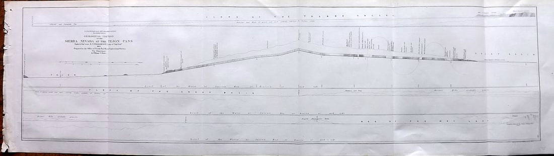
Sold2023Williamson, Lieut. R. S. 1856 LG Chart. California - Sierra Nevada & Tejon Pass"Goelogical Section of the Sierra Nevada at the Tejon Pass" by R. S. Williamson. Lithograph Map Published 1853-61, Washington for "Reports of explorations and surveys, to ascertain the most practicablSee Sold Price
Sold2023Williamson, Lieut. R. S. 1856 LG Chart. California - Bernadino Pass, San Bernardino, Colorado Desert"Geological Sections of the Bernadino Pass" Lithograph Map Published 1853-61, Washington for "Reports of explorations and surveys, to ascertain the most practicable and economical route for a railroadSee Sold Price
Sold2023Williamson, Lieut. R. S. 1856 LG Chart. California - Colorado Desert"Sections of the Colorado Desert" Explored by Lieut R. S. Williamson. Lithograph Map Published 1853-61, Washington for "Reports of explorations and surveys, to ascertain the most practicable and econoSee Sold Price
Sold2023U S Coast Survey 1856 Large Map. St. Mary's Bar & Fernandina Harbor Florida"Preliminary Chart of St. Mary's Bar and Fernandina Harbor Florida"Large Lithograph Map Published 1857, Washington for "U.S. Coast and Geodetic Survey" Folds as issued. Paper Size: 25 x 23 inch (64 xSee Sold Price
Sold2022(AMERICAN NORTHWEST.) La Perouse; after. Chart of the North West Coast of America(AMERICAN NORTHWEST.) La Perouse; after. Chart of the North West Coast of America Explored by the Boussole & Astrolabe in 1786. 3rd Sheet. Double-page engraved chart of the California and Oregon coastSee Sold Price
Sold2023Perry, Commodore 1856 Large Map. China, Japan & Philippines"Chart of the coast of China and of the Japan Islands including the Marianes and a part of the Philippines" Large Folio Lithograph Map Published 1856, Washington for "Narrative of the Expedition of anSee Sold Price
Sold2015Suisun Bay, CaliforniaHeading: (California) Author: U.S. Coast Survey Title: Suisun Bay, California Place Published: Washington Publisher: Date Published: 1867 Description: Lithographed chart. 44See Sold Price
Sold2018Antique 1856 US Coastal Survey of Martha's VineyardTitle/Content of Map: 1856 US Coastal Survey of Martha's Vineyard amd Nantucket Area in Massachusetts -- Preliminary Chart of Part of the Sea Coast of Massachusetts from Saughkonnet River to PlymouthSee Sold Price
Sold2022(MEXICO.) Robert Dudley. Carta Particolare della Parte Ocidentale della Nuova Spagnia, e del la(MEXICO.) Robert Dudley. Carta Particolare della Parte Ocidentale della Nuova Spagnia, e del la California. Large double-page engraved chart of the Pacific coast of Mexico and the southern tip of theSee Sold Price
Sold2017Nautical Chart and Coastal Map of Monterey Bay, 1852Map: 1852 Nautical Chart and Coastal Map of Monterey Bay, California -- Monterey Harbor, CA from a Trigonometrical Survey Cartographer: US Coast Survey Year / Place: 1852 Map Dimensions: 13.1 x 11.7 iSee Sold Price
Sold2018Vancouver: Antique Chart of Northwest Coast of AmericaTitle/Content of Map: A Chart Shewing Part of the Coast of N.W. America, with the Tracks of His Majesty's Sloop Discovery and Armed Tender Chatham . . . [Columbia River to Northern California] Date PrSee Sold Price
Sold20221856 Chart of The Hudson River from Albany to New Baltimore -- Map of Comparison of Hudson RiverTitle: 1856 Chart of The Hudson River from Albany to New Baltimore -- Map of Comparison of Hudson River from Albany to New Baltimore Cartographer: US Coast Survey Year / Place: 1856 Map Dimension (in.See Sold Price
Sold2017USCGS: Antique Coastal Chart Map of Suisun Bay, 1870Title/Content of Map: 'Suisunbay California from a Trigonometrical survey under the direction of A.D. Bache, Superintendent of the survey of the Coast of the United States Published by 1872' COASTAL CSee Sold Price
Sold2021Nautical Map / Sea Chart, #362 Block Island Sound andDescription: Nautical Map / Sea Chart, United States East Coast, New York, Long Island, Block Island Sound and Gardiner's Bay, 6th edition, Feb 10/69; Shipping: $20; different rate to California, AlasSee Sold Price
Sold2018Howard Russell Butler Main Coastal Oil PaintingOriginal oil on canvas seascape painting by Howard Russell Butler (1856-1934 California / New Jersey) Heavy Seas Saddle Rock 1917 depicts a rocky shore of the Maine coast. Signed lower right. ExhibitiSee Sold Price
Sold2017Nautical Coastal Map of San Clemente Harbor, 1852Map: 1852 US Coast Guard Nautical Chart and Coastal Map of San Clemente Harbor California -- Reconnaissance of San Clemente Harbor, CA and Reconnaissance of Prisoners's Harbor and Cuyler's harbor andSee Sold Price
3 days LeftSchilb Antiquarian Rare Books1856 California 1ed John Fremont Exploration Memoirs Oregon Trail Nevada IndiansUS$115(5 bids)
Featured6 days LeftJasper52Chart of the Sea Coasts of England, Flanders & Holland. MOUNT & PAGE 1758 mapUS$420
6 days LeftJasper52A Chart of the Sea Coast from England to the Streights. MOUNT & PAGE 1758 mapUS$500
Jun 02Schilb Antiquarian Rare Books1856 Fremont Illustrated American Exploration California Rocky Mountains SmuckerUS$1(1 bid)
2 days LeftAmazing Collectible GalleriesAmazing Colin Campbell Cooper Still Life Oil CanvasUS$500(1 bid)
7 days LeftZikorn Arts & History ObjectsWest Indies, Western Cuba 1879 British Admiralty Nautical MapUS$100
May 18Art Legacy AuctionsCalifornia Coast Highway Mixed Media original on canvas David Lloyd GloverUS$1,240
2 days LeftArt Legacy AuctionsCalifornia Coast Highway Mixed Media original on canvas David Lloyd GloverUS$1,250


![Vancouver: Antique Chart of Northwest Coast of America: Title/Content of Map: A Chart Shewing Part of the Coast of N.W. America, with the Tracks of His Majesty's Sloop Discovery and Armed Tender Chatham . . . [Columbia River to Northern California] Date Pr](https://p1.liveauctioneers.com/5584/114563/58815189_1_x.jpg?height=310&quality=70&version=1514941693)


