Sold2022BRITISH ISLES LILY (GEORGE) Britanniae insulae quae nunc Angliae et Scotiae regna continet cum H...BRITISH ISLES LILY (GEORGE) Britanniae insulae quae nunc Angliae et Scotiae regna continet cum Hibernia adiacente nova descriptio, double-page engraved map, land masses hand-coloured, title cartoucheSee Sold Price
Sold2023After John Hoppner (British, 1758-1810)After John Hoppner (British, 1758-1810) William Jennens Peareth oil on canvas 30 1/4 x 25 1/8 inches. This lot is located in Chicago. Property from the Pamela K. Hull Trust, Chicago, Illinois ProveSee Sold Price
Sold2022Manner of John Hoppner, Robin Vanecke, oilIn the manner of John Hoppner (British, 1758-1810)Portrait of Master Robin Vaneckeoil on canvas54 1/2 x 36in (138 x 91.5cm)See Sold Price
Sold2015John Hoppner, R.A. (British, 1758-1810)John Hoppner, R.A. (British, 1758-1810), "Portrait of a Gentleman Identified in the Dillon Collection as Hon. James William Dillon (1792-1812), Son of Charles Dillon, the 12th Viscount", ca. 1808, oilSee Sold Price
Sold2022LARGE ARCHITECTS PRINT / MAP / CHART CABINETFantastic very large Architectural draftsman/chart/map/print flat file - George III-Style mahogany with satinwood inlay, inset tooled leather top. 8 Drawer over 4 drawer. from the Audubon Gallery, KinSee Sold Price
Sold2017DIDIER ROBERT DE VAUGONDY (FRENCH, 1688-1766) ATLASDIDIER ROBERT DE VAUGONDY (FRENCH, 1688-1766) ATLAS VOLUME "Atlas Universel", 1757, folio, leather boards, engraved title page, 106 hand-colored double-page maps, missing numbers 24 and 40. With proteSee Sold Price
Sold2022Alfred Wallis (British, 1855-1942) Mount's Bay with St Michael's Mount 23.5 x 33 cm. (9 1/4 x 13...Alfred Wallis (British, 1855-1942) Mount's Bay with St Michael's Mount signed 'A WALLIS' (lower right) oil on panel 23.5 x 33 cm. (9 1/4 x 13 in.) Footnotes: Provenance Ben Nicholson and Dame BarbaraSee Sold Price
Sold2016JOHN SPEED (BRITISH, 1552-1629) MAP OF THE WORLDJOHN SPEED (BRITISH, 1552-1629) MAP OF THE WORLD, (UPDATED 6/14/16) hand-colored engraving on laid paper, titled "A New and Accurat Map of the World Drawne according to ye truest Descriptions latest DSee Sold Price
Sold2022Platinum and Diamond RingPlatinum and Diamond Ring centering on a marquise brilliant cut diamond (16.04 x 6.72 x 4.28 mm) weighing 2.63 carats (actual) (H color, VS2 clarity), the wide tapered mount channel set with princessSee Sold Price
Sold2022Paul Mount, Two Dancers, steelPaul Mount (British, 1922-2009)Two Dancerssteelthe base signed Paul Mount and numbered 3/7overall height 12 1/2in (32cm) Provenance:Property from a Private Southern CalifornSee Sold Price
Sold2022ORTELIUS, ABRAHAM. Typus Orbis Terrarum.ORTELIUS, ABRAHAM. Typus Orbis Terrarum. Double-page engraved map of the world. 16¾x20½ inches sheet size, wide margins, Dutch text on verso; original hand-color; professionally conserved wiSee Sold Price
Sold2022ORTELIUS, ABRAHAM. Americae Sive Novi Orbis, Nova Descriptio.ORTELIUS, ABRAHAM. Americae Sive Novi Orbis, Nova Descriptio. Double-page engraved map of the Western Hemisphere. 17½x22¼ inches sheet size, wide margins, Spanish text on verso; uncolored; cSee Sold Price
Sold2023(NORTH AMERICA.) Henricus Hondius. America Septentrionalis.(NORTH AMERICA.) Henricus Hondius. America Septentrionalis. Double-page engraved map of North America with California as an island and attractive carto-ornamentation. 19¼x23½ inches sheet siSee Sold Price
Sold2024Schedel, Hartmann "Secunda Etas Mundi"Double page wood engraved map from the Latin version of the Nuremburg Chronicle, 1493See Sold Price
Sold2022(NETHERLANDS.) Nicolaas and Jacob Cruquius. T Hooge Heemraedschap van Delflant.(NETHERLANDS.) Nicolaas and Jacob Cruquius. T Hooge Heemraedschap van Delflant. Atlas-format wall map of the vicinity of Delft and The Hague in western Netherlands. Double-page engraved key map in stuSee Sold Price
Sold2021(CELESTIAL.) Ignace Gaston Pardies. [Plate 6 -(CELESTIAL.) Ignace Gaston Pardies. [Plate 6 - Constellations of the Southern Sky]. Hand-colored double-page engraved celestial chart with flanking descriptive columns in Latin and French. 19x28¼See Sold Price
Sold2022(BRITISH EMPIRE.) George Philip & Son, Ltd.; and The London Geographical Institute. Navy League Map(BRITISH EMPIRE.) George Philip & Son, Ltd.; and The London Geographical Institute. Navy League Map of the British Empire. Oversize chromolithograph map of the world delineating early 20th-century BriSee Sold Price
Sold2022(CIVIL WAR.) John Bachmann. Panorama of the Seat of War.(CIVIL WAR.) John Bachmann. Panorama of the Seat of War. Portfolio of 6 double-page chromolithographed panoramic perspective maps of Confederate states. Folio, 23½x17 inches, contemporary half moSee Sold Price
Sold2022CAREY, HENRY CHARLES; and ISAAC LEA. A Complete Historical, Chronological, and Geographical AmericanCAREY, HENRY CHARLES; and ISAAC LEA. A Complete Historical, Chronological, and Geographical American Atlas. 53 numbered double-page engraved mapsheets, charts and letterpress tables (complete.) Folio,See Sold Price
Sold2021History of the World by Sir Walter Ralegh 1614 1stThe History of the World In Five Books by Sir Walter Ralegh (Raleigh). 1614. At London Printed for Walter Burre. 669 pp. Includes engraved title page; frontispiece and 8 maps with Chronological TableSee Sold Price
Sold2022Fabulous World Wide Collection.(8) Banker Boxes Loaded with Mint Sets and Singles on album Pages. Great selection of British Commonwealth and Topical collections. All are mint and appear complete to the High Values. The lot also inSee Sold Price
Sold2022A British sailor's woolwork 'Woolie' of The Channel Fleet, together with another, and a woolwork...A British sailor's woolwork 'Woolie' of The Channel Fleet, together with another, and a woolwork picture (3) Mid-19th century Depicting the fleet in full sail, with the White Cliffs of Dover in the diSee Sold Price
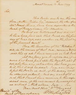
Sold2018WASHINGTON, George (1732-1799).* WASHINGTON, George (1732-1799). Autograph letter signed ("Go: Washington"), to Samuel M. Fox, President of the Bank of Pennsylvania. Mount Vernon, 10 June 1799. 1 page, 4to, pinholes in upper cornerSee Sold Price
5 days LeftJasper52Chart of the British Channel… Halley's tides & currents. MOUNT & PAGE 1758 mapUS$750
5 days LeftJasper52A Large Chart of the Channell between England and France. Tides. HALLEY 1702 mapUS$3,600
5 days LeftJasper52A New and Correct Chart of England, Scotland and Ireland. MOUNT & PAGE 1758 mapUS$260
5 days LeftJasper52A Chart of the Sea Coast from England to the Streights. MOUNT & PAGE 1758 mapUS$500
5 days LeftJasper52A Chart of the Coasts of Ireland & part of England. Wales. MOUNT & PAGE 1758 mapUS$550
5 days LeftJasper52Chart of the Newcastle Trade describing… coast of England. MOUNT & PAGE 1758 mapUS$550
5 days LeftJasper52The South-West Coast of Ireland from Dungarvan to… Shannon MOUNT & PAGE 1758 mapUS$280
5 days LeftJasper52The Sea Coast of France from Ushent to Olone [Olonne]. MOUNT & PAGE 1758 mapUS$280
5 days LeftJasper52The Sea Coasts of France from Olone to Cape Machiacaca. MOUNT & PAGE 1758 mapUS$280
5 days LeftJasper52Chart of the Coast of Portugal & Barbaria... Canarie Isles MOUNT & PAGE 1758 mapUS$340
5 days LeftJasper52Antique sea 'Chart of the Islands of Cape Verd' [Verde]. MOUNT & PAGE 1758 mapUS$260
5 days LeftJasper52Chart of the Sea Coasts Biscay & Gallicia [Galicia]. Spain MOUNT & PAGE 1758 mapUS$360
5 days LeftJasper52Chart of the Sea Coasts of England, Flanders & Holland. MOUNT & PAGE 1758 mapUS$420
5 days LeftJasper52The River of Thames from London to the Buoy of ye Noure. MOUNT & PAGE 1758 mapUS$700
BonhamsEAST AFRICA DE WIT (FREDERICK) Occidentalior Tractus Indiarum Orientalium a Promontorio Bonae Sp...£300(1 bid)
348 Lots AwayFreeman's | Hindman[MAP]. SARTINE, Antoine Plan de la Barre et du Havre de Charles-Town...1778. RARE REVOLUTIONARY WARUS$1,000(1 bid)
6 days LeftSwann Auction Galleries(HONDURAS -- ROATAN ISLAND.) Lieutenant Henry Barnsley; and William H. Toms, engraver. A Draught ofUS$750
BonhamsLieutenant Francis Henry Boyer (British, 1854-1926) Collision between HMS Himalaya and Danish Br...£400
BonhamsIRELAND - ULSTER COVENANT, U.V.F., CARSON AND CRAIG Album relating to the Ulster Covenant, James...£10
BonhamsWEST AFRICA DE WIT (FREDERICK) Tractus Littorales Guineae a Promontorio Verde usque ad Sinum Cat...£10(1 bid)
BonhamsBLAEU (JAN) Delfi Batavorum vernacule Delft, [Amsterdam, 1649 or later]; BLAEU (WILLEM) Novus X...£10


![(CELESTIAL.) Ignace Gaston Pardies. [Plate 6 -: (CELESTIAL.) Ignace Gaston Pardies. [Plate 6 - Constellations of the Southern Sky]. Hand-colored double-page engraved celestial chart with flanking descriptive columns in Latin and French. 19x28¼](https://p1.liveauctioneers.com/199/226915/117191944_1_x.jpg?height=310&quality=70&version=1637249113)


![The Sea Coast of France from Ushent to Olone [Olonne]. MOUNT & PAGE 1758 map (1 of 1)](https://p1.liveauctioneers.com/5584/332390/179263262_1_x.jpg?height=282&quality=70&version=1717528223)


![Antique sea 'Chart of the Islands of Cape Verd' [Verde]. MOUNT & PAGE 1758 map (1 of 1)](https://p1.liveauctioneers.com/5584/332390/179263189_1_x.jpg?height=282&quality=70&version=1717528223)
![Chart of the Sea Coasts Biscay & Gallicia [Galicia]. Spain MOUNT & PAGE 1758 map (1 of 1)](https://p1.liveauctioneers.com/5584/332390/179263007_1_x.jpg?height=282&quality=70&version=1717528223)


![[MAP]. SARTINE, Antoine Plan de la Barre et du Havre de Charles-Town...1778. RARE REVOLUTIONARY WAR (1 of 1)](https://p1.liveauctioneers.com/197/329395/177650540_1_x.jpg?height=282&quality=70&version=1715364962)


![AFRICA BLAEU (WILLEM) Africae nova descriptio, [c. 1630 or later] (1 of 2)](https://p1.liveauctioneers.com/1043/316318/178467347_1_x.jpg?height=282&quality=70&version=1717777204)
![BLAEU (JAN) Delfi Batavorum vernacule Delft, [Amsterdam, 1649 or later]; BLAEU (WILLEM) Novus X... (1 of 9)](https://p1.liveauctioneers.com/1043/319451/178359083_1_x.jpg?height=282&quality=70&version=1717776896)