Sold2024Maps and Travel Posters, Group of 9Lot 238 Maps and Travel Posters, Group of 9 comprising Across the Continent Travel Board cover, Ohio State Fair poster, map of Europe, and map of Windward Islands,and map in glass tube, along with trSee Sold Price
Sold2022Hezekiah Anthony Dyer Harbor Ships PaintingRhode Island, Europe,1872-1943 Impressionist depiction of sailboats and floating in a harbor with a vast city skyline in the distance. Dyer studied in both Italy, Holland, and France and was an activeSee Sold Price
Sold2022DODGE MACKNIGHT (Massachusetts/Connecticut/Rhode Island/Europe, 1860-1950), Figures on a tree-linedDODGE MACKNIGHTMassachusetts/Connecticut/Rhode Island/Europe, 1860-1950Figures on a tree-lined street. Signed lower left “Dodge Macknight”.Watercolor on paper, 14" x 21" sight. FSee Sold Price
Sold2021Attrib. Emily Burling Waite Portrait PaintingAttrib. Emily Burling Waite Massachusetts, Rhode Island, Europe,1887-1980 Depicts a young girl dressed in pink with a book on her lap. Waite studied at the Worcester Art Museum under Philip Leslie HalSee Sold Price
Sold2022HEZEKIAH ANTHONY DYER (Rhode Island/Europe, 1872-1943), A doorway., Watercolor and gouache on paper,HEZEKIAH ANTHONY DYERRhode Island/Europe, 1872-1943A doorway. Signed lower right “H.A. Dyer”.Watercolor and gouache on paper, 10" x 7.75" sight. Framed 17.75" x 15.5".See Sold Price
Sold2023Geography COUNTRIES OF THE WORLD 6 vol Brown c1881Brown, Robert; The Countries of the World : [6 volumes] Being a popular description of the various continents, islands, rivers, seas, and peoples of the globe; London: Cassell, Petter, Galpin & Co cirSee Sold Price
Sold2021Golf, Lee Westwood signed and mounted colourGolf, Lee Westwood signed and mounted colour presentation photograph, approx 16x12. Noted for his consistency, Westwood is one of the few golfers who has won tournaments on five continents - Europe, NSee Sold Price
Sold2022HERRERA Y TORDESILLAS, ANTONIO DE The general history of the vast continent and islands of America,HERRERA Y TORDESILLAS, ANTONIO DE The general history of the vast continent and islands of America, commonly call'd, the West-Indies.. London: Jer.[emiah] Batley (printed by Samuel Palmer and others),See Sold Price
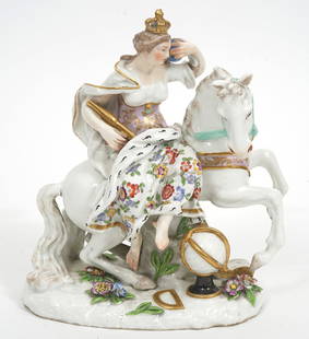
Sold2023Meissen Porcelain Allegory of Continent of EuropeMeissen hand-painted porcelain figure "Allegory of The Continent of Europe", features female monarch on horseback. Measures 6.5"L x 3.5"W x 7.5"H. Condition report: Chip to crown of figure, please exaSee Sold Price
Sold2023The American Universal Geography, Part 2: Eastern Continent and Islands, by Jedidiah Morse 1805The American Universal Geography, Part 2: Eastern Continent and Islands, by Jedidiah Morse 1805 Overall good to fair condition.See Sold Price
Sold2021Barlow 1807 Antique Map of Europe ContinentCopper Engraved Map Published 1807 by Brightly & Kinnersley, Bungay, England for "A General View of the World, Geographical, Historical and Philosophical" by The Rev. E. Blomfield. Maps Engraved by BaSee Sold Price
Sold2021Guthrie, William 1798 Map. Europe ContinentCopper Engraved Map Published 1798, London for "A New Geographical, Historical and Commercial Grammar..." by William Guthrie. The maps are by John Senex, Thomas Kitchin and others. Folds as issued. PaSee Sold Price
Sold2022Guthrie & Kitchin 1782 Map. Europe ContinentCopper Engraved Map Published 1782, London for "A New Geographical, Historical and Commercial Grammar..." by William Guthrie. The maps are by John Senex, Thomas Kitchin and others. Folds as issued. PaSee Sold Price
Sold2020Barlow 1807 Antique Map of Europe ContinentCopper Engraved Map Published 1807 by Brightly & Kinnersley, Bungay, England for "A General View of the World, Geographical, Historical and Philosophical" by The Rev. E. Blomfield. Maps Engraved by BaSee Sold Price
Sold2019Delamarche, Felix 1829 Map of Europe Continent"L'Europe Divisee en ses differens Etats" Copper Engraved Map Published 1829, Paris for "Atlas de La Geographie..." by Felix Delamarche. Contemporary outline hand colour. Centre fold as published. PapSee Sold Price
Sold2018Barlow 1807 Antique Map of Europe ContinentCopper Engraved Map Published 1807 by Brightly & Kinnersley, Bungay, England for "A General View of the World, Geographical, Historical and Philosophical" by The Rev. E. Blomfield. Maps Engraved by BaSee Sold Price
Sold2021Guthrie, William 1806 Map. Europe ContinentCopper Engraved Map Published 1806, London for "A New Geographical, Historical and Commercial Grammar..." by William Guthrie. The maps are by John Senex, Thomas Kitchin and others. Folds as issued. PaSee Sold Price
Sold2018Antique German Meissen Porcelain Figural Group "Europe"Antique German Meissen hand painted porcelain figural group "The Continent of Europe" from the Series of Four Continents originally designed by Kaendler, features the queen, her horse and other itemsSee Sold Price
Sold2023[OLDMIXON, John]. The British Empire in America. FIRST EDITION.[OLDMIXON, John (1673-1742)]. The British Empire in America, Containing the History of the Discovery, Settlement, Progress and Present State of all the British Colonies on the Continent and Islands ofSee Sold Price
Sold2023"Europa das ein Drittheil der Erden nach Gelegenheit unsern Zeiten", Sebastian Munster, ca. 1569"Europa das ein Drittheil der Erden nach Gelegenheit unsern Zeiten". (First Map of the Continent of Europe). Basle, ca. 1569. Sebastian Munster (German 1488-1552), was a cartographer, cosmographer, anSee Sold Price
Sold2024History Napoleonic Wars, 5 Volumes, Napier 1856History About Napoleonic Wars, 5 Volumes, Napier 1856. This five-volume set by W. F. P. Napier is about Napoleon?s campaigns to take over the continent of Europe in the early 1800?s, and the set is tiSee Sold Price
Sold2021Map LotLot (2) maps mounted on cardboard "The Supplement to / NORTH AMERICA" and "The Continent and Islands of AMERICA…", each 21" x 47 1/2".See Sold Price
Sold201817th Century European Drawing Europa17th cent European Drawing Europa Pen/wash 12.75x10.25 Europa, mother of King Minos of Crete, a woman with Phoenician origin of high lineage, and after continent of Europe was named. Drawing on periodSee Sold Price
Sold2021Tallis, John (Pub) 1852 Lot of 12 European MapsIncl Northern Italy, Southern Italy, Brussels, Germany, Spain and Portugal, Prussia, Europe Continent, Greece, Denmark, Belgium, Holland and France. Steel Engraved Maps with Original Outline Hand ColoSee Sold Price
2 days LeftTrillium Antique Prints & Rare BooksWilkes - 6 View Engravings of New Zealand, Tonga, Fiji, &c.US$100
2 days LeftTrillium Antique Prints & Rare BooksWilkes - 13 Native People Engravings (Portrait of Commanders including Wilkes, people from NewUS$100
Jun 28Galerie Zacke AN INSCRIBED JAIN COSMOLOGICAL DIAGRAM DEPICTING TRILOKA (THE THREE WORLDS), GUJARAT, 16TH CENTURY€4,000
BonhamsBOTERO (GIOVANNI) Le relationi universali... novamente ristampate, & ricorrette -Aggiunta alla q...£5,000
Jun 08Leon GalleryJustiniano Asunción (1816 - 1901) - Tipos del Pais (People of the Country) Studies of the People of₱2,000,000
3 days LeftTremont AuctionsJoseph Mellor Hanson. 1956. Matinicus Island, Maine. "Matinicus and Her Satelites". Coastal seascapeUS$200(1 bid)
Echoes of Glory International Military Auction HouseWWII Bringback Philippine Islands Native Cleaver Machete (A)US$35(2 bids)


![Geography COUNTRIES OF THE WORLD 6 vol Brown c1881: Brown, Robert; The Countries of the World : [6 volumes] Being a popular description of the various continents, islands, rivers, seas, and peoples of the globe; London: Cassell, Petter, Galpin & Co cir](https://p1.liveauctioneers.com/8089/278805/146838321_1_x.jpg?height=310&quality=70&version=1676590384)

![HERRERA Y TORDESILLAS, ANTONIO DE The general history of the vast continent and islands of America,: HERRERA Y TORDESILLAS, ANTONIO DE The general history of the vast continent and islands of America, commonly call'd, the West-Indies.. London: Jer.[emiah] Batley (printed by Samuel Palmer and others),](https://p1.liveauctioneers.com/292/250642/130213594_1_x.jpg?height=310&quality=70&version=1654271664)


![[OLDMIXON, John]. The British Empire in America. FIRST EDITION.: [OLDMIXON, John (1673-1742)]. The British Empire in America, Containing the History of the Discovery, Settlement, Progress and Present State of all the British Colonies on the Continent and Islands of](https://p1.liveauctioneers.com/197/305583/163286615_1_x.jpg?height=310&quality=70&version=1697143109)


![[MAP]. ORTELIUS, Abraham. Romani Imperii Imago. 1592. (1 of 2)](https://p1.liveauctioneers.com/197/329395/177650537_1_x.jpg?height=282&quality=70&version=1715364962)


