Sold2017Cram: Antique Map of Indian Territory, 1891Map: Indian Territory Date: 1891 From Cram's "Unrivaled Family Atlas of the World Indexed" Size: 14.5 x 11 inches George F. Cram (1842-1928) served in the U.S. Army during the American Civil War. AfteSee Sold Price
Sold2017Cram: Antique Map of Texas, Indian Territory, ArkansasTitle/Content of Map: 1885 Cram Map of Texas, [verso] Indian Territory and Arkansas -- Texas, [verso] Indian Ty; Arkansas Date Printed: 1885, Chicago Cartographer: G Cram Size: 12 x 17 in. This is a nSee Sold Price
Sold2018Cram: Antique Map of Texas, 1886Title/Content of Map: 1886 Cram Map of Texas / Arkansas and Indian Territory on Verso -- Texas; Arkansas; Indian Ty. Date Printed: 1886, Chicago Cartographer: G Cram Size: 11.8 x 17 in. Handsomely detSee Sold Price
Sold2020Indian Territory 1891Title/Content of Map: Indian Territory 1891 Date Printed: 1891 Material/Medium: Paper Size: approx 10.5x14.5 inches Additional Info: Cram's Atlas of the World. Geo. F. Cram, Chicago Reserve: $20.00 SSee Sold Price
Sold2018Asher & Adams: Antique Map of Indian Territory, 1874Title/Content of Map: 1874 Asher & Adams Indian Territory Map -- Asher & Adams Indian Territory and Texas North West Portion Date Printed: 1874, New York Cartographer: Asher & Adams Size: 16.3 x 23.2See Sold Price
Sold2017G.P Strum: Antique Map of Indian Territory, 1883Title: Map of Indian Territory by G.P Strum Date: 1883 Medium: Lithograph Dimensions (in): 33.5 x 25.5 Condition: Great Condition No Reserve: This lot starts at $1 and has no reserve as a courtesy soSee Sold Price
Sold2016Antique Map : Oklahoma Indian Territory - 1903Antique Map : Oklahoma Indian Territory - 1903. Size : 21.5" x 13.5"See Sold Price
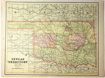
Sold2017Cram: Map of Indian Territory, 1889An original map published in 1889 depicting the Indian Reservations in what is now the state of Oklahoma. 9.5 x 12" Please note that this lot has a reserve. When you leave a bid in advance of the auctSee Sold Price
Sold2023Two Antique Maps of Indian Territories British America Far WestTwo Antique Maps of Indian Territories British America Far West MEDIUM: Published Printing DIMENSIONS: Framed 18 x 27 inches DESCRIPTION: These early antique maps of British America show Districts, InSee Sold Price
Sold2017Fullarton: Antique Map of Texas & Indian Territory 1860Map: 1860 Fullarton Map of Texas (East/Central), Indian Territory, Louisiana and Arkansas -- United States North America According to Calvin Smith& Tanner . . . South Central Section. Comprising TexasSee Sold Price
Sold2017Rand McNally: Antique Map of Texas & Indian TerritoryMap: 1895 Rand McNally Map of Texas and Indian Territory/Oklahoma -- Texas; Oklahoma and Indian Territory Cartographer: Rand McNally Year / Place: 1895 Chicago Map Dimensions: 9.2 x 12.5 in. ConditionSee Sold Price
Sold2017Rand McNally: Antique Map of Texas & Indian TerritoryTitle/Content of Map: 1895 Rand McNally Map of Texas and Indian Territory/Oklahoma -- Texas; Oklahoma and Indian Territory Date Printed: 1895 Chicago Cartographer: Rand McNally Size: 9.2 x 12.5 in. CoSee Sold Price
Sold2017Cram: Antique Map of California, 1891Map: California Date: 1891 From Cram's "Unrivaled Family Atlas of the World Indexed" Size: 14 x 22 inches George F. Cram (1842-1928) served in the U.S. Army during the American Civil War. After the waSee Sold Price
Sold20191886 Cram Map of Texas [verso] Indian Territory [verso]Title/Content of Map: 1886 Cram Map of Texas [verso] Indian Territory [verso] Arkansas -- Texas [verso] Indian Ty. [verso] Arkansas Date: 1882, Chicago Cartographer: G CramSize: 12 X 17 in. This is aSee Sold Price
Sold20201886 Cram Map of Texas [verso] Indian Territory [verso]Title/Content of Map: 1886 Cram Map of Texas [verso] Indian Territory [verso] Arkansas -- Texas [verso] Indian Ty. [verso] Arkansas Cartographer: G Cram /People's Publishing Co. Year/Place: 1886, ChicSee Sold Price
Sold20201887 Cram Map of Texas [verso] Indian Territory [verso]Title/Content of Map: 1887 Cram Map of Texas [verso] Indian Territory [verso] Arkansas -- Texas [verso] Indian Ty. [verso] Arkansas Date: 1887, Chicago Cartographer: G Cram Size: 12 X 17 in. This is aSee Sold Price
Sold20201886 Cram Map of Texas [verso] Indian Territory [verso]Title/Content of Map: 1886 Cram Map of Texas [verso] Indian Territory [verso] Arkansas -- Texas [verso] Indian Ty. [verso] Arkansas Date: 1886, Chicago Cartographer: G Cram Size: 12 X 17 in. This is aSee Sold Price
Sold20221886 Cram Map of Texas [verso] Indian Territory [verso] Arkansas -- Texas [verso] Indian Ty. [verso]Title: 1886 Cram Map of Texas [verso] Indian Territory [verso] Arkansas -- Texas [verso] Indian Ty. [verso] Arkansas Cartographer: G Cram Year / Place: 1886, Chicago Map Dimension (in.): 11.8 X 17 in.See Sold Price
Sold20231884 Cram Map of Texas [verso] Indian Territory [verso] Arkansas -- Texas [verso] Indian Ty. [verso]Title: 1884 Cram Map of Texas [verso] Indian Territory [verso] Arkansas -- Texas [verso] Indian Ty. [verso] Arkansas Cartographer: G Cram Year / Place: 1884, Chicago Map Dimension (in.): 11.8 X 17 in.See Sold Price
Sold20181886 Cram Map of Texas [verso] Indian Territory [and]Reserve Reduced! Title/Content of Map: 1886 Cram Map of Texas [verso] Indian Territory [and] Arkansas -- Texas [verso] Indian Ty. [and] Arkansas Date: 1886, Chicago Cartographer: G Cram Size: 11.8 x 1See Sold Price
Sold20191886 Cram Map of Texas [verso] Indian Territory [verso]Title/Content of Map: 1886 Cram Map of Texas [verso] Indian Territory [verso] Arkansas -- Texas [verso] Indian Ty. [verso] Arkansas Date: 1882, Chicago Cartographer: G Cram Size: 12 X 17 in. This is aSee Sold Price
Sold2017Cram: Antique Driving Map of Philadelphia, 1891Map: New Driving Map of Philadelphia Date: 1891 From Cram's "Unrivaled Family Atlas of the World Indexed" Size: 22 x 14 inches George F. Cram (1842-1928) served in the U.S. Army during the American CiSee Sold Price
2017Cram: Antique Map of Northern Hemisphere, 1891Map: Global View of Northern Hemisphere Date: 1891 From Cram's "Unrivaled Family Atlas of the World Indexed" Size: 11 x 14.5 inches George F. Cram (1842-1928) served in the U.S. Army during the AmericSee Sold Price
Sold20221902 Cram Map of Oklahoma and Indian TerritoriesTitle: 1902 Cram Map of Oklahoma and Indian Territories [verso] New Mexico -- Oklahoma and Indian Territories [verso] New Mexico Cartographer: G Cram Year/Place: 1902, Chicago Dimensions: 9.5 X 12.8 iSee Sold Price
3 days LeftJasper521887 Cram Map of Texas [verso] Indian Territory [verso] Arkansas -- Texas [verso] Indian Ty. [verso]US$95
Jun 12Dan Morphy AuctionsPLATE CXIII. MAP OF INDIAN TERRITORY SHOWING DISTRIBUTION OF WOODLAND” FROM THE TWENTY-FIRSTUS$100
3 days LeftJasper521898 Rand McNally Map of Texas [verso] Indian Territory and Oklahoma -- Texas [verso] Oklahoma andUS$70
Jun 12Dan Morphy AuctionsMAP OF THE CHOCTAW NATION, INDIAN TERRITORY - COAL AND ASPHALT SEGREGATION 1903US$150
Jun 12Dan Morphy AuctionsMAP OF THE CHOCTAW NATION, INDIAN TERRITORY - COAL AND ASPHALT SEGREGATION 1903US$100
Featured3 days LeftJasper52Mitchell’s Map of Asia showing travel routes London, India, China & Japan, 1860US$45
Jun 12Dan Morphy AuctionsINDIAN TERRITORY - DEPARTMENT OF THE INTERIOR GENERAL LAND OFFICE, C.1883US$100
4 days LeftJasper52YUGOSLAVIA. Fiume Sarajevo Zagreb Belgrade. Disputed/Italian territory 1920 mapUS$40
4 days LeftJasper52South-west Europe. Swiss Savoy. British Hanover. THOMSON 1817 old antique mapUS$100
5 days LeftAlbion AuctionsNat. Encyclo. 1890's Pair of Celestial Maps. Northern & Southern ConstellationsUS$10(2 bids)
4 days LeftJasper52YUGOSLAVIA. Trieste international zone. Slovenian Istria. BARTHOLOMEW 1947 mapUS$30
4 days LeftJasper52Europe. Unified Benelux. Switzerland includes Haute-Savoie. THOMSON 1830 mapUS$120
Featured4 days LeftJasper52Europe after the Congress of Vienna. 4 sheets. 128x106cm. THOMSON 1817 old mapUS$550
4 days LeftJasper52OTTOMAN EMPIRE in Europe & Asia. Greece. British Ionian Islands. SDUK 1844 mapUS$65


![Cram: Antique Map of Texas, Indian Territory, Arkansas: Title/Content of Map: 1885 Cram Map of Texas, [verso] Indian Territory and Arkansas -- Texas, [verso] Indian Ty; Arkansas Date Printed: 1885, Chicago Cartographer: G Cram Size: 12 x 17 in. This is a n](https://p1.liveauctioneers.com/5584/113749/58452563_1_x.jpg?height=310&quality=70&version=1513734097)


![1886 Cram Map of Texas [verso] Indian Territory [verso]: Title/Content of Map: 1886 Cram Map of Texas [verso] Indian Territory [verso] Arkansas -- Texas [verso] Indian Ty. [verso] Arkansas Date: 1882, Chicago Cartographer: G CramSize: 12 X 17 in. This is a](https://p1.liveauctioneers.com/5584/137769/69881200_1_x.jpg?height=310&quality=70&version=1552435690)
![1886 Cram Map of Texas [verso] Indian Territory [verso]: Title/Content of Map: 1886 Cram Map of Texas [verso] Indian Territory [verso] Arkansas -- Texas [verso] Indian Ty. [verso] Arkansas Cartographer: G Cram /People's Publishing Co. Year/Place: 1886, Chic](https://p1.liveauctioneers.com/5584/175972/88577718_1_x.jpg?height=310&quality=70&version=1597183226)
![1887 Cram Map of Texas [verso] Indian Territory [verso]: Title/Content of Map: 1887 Cram Map of Texas [verso] Indian Territory [verso] Arkansas -- Texas [verso] Indian Ty. [verso] Arkansas Date: 1887, Chicago Cartographer: G Cram Size: 12 X 17 in. This is a](https://p1.liveauctioneers.com/5584/164510/83043299_1_x.jpg?height=310&quality=70&version=1585094571)
![1886 Cram Map of Texas [verso] Indian Territory [verso]: Title/Content of Map: 1886 Cram Map of Texas [verso] Indian Territory [verso] Arkansas -- Texas [verso] Indian Ty. [verso] Arkansas Date: 1886, Chicago Cartographer: G Cram Size: 12 X 17 in. This is a](https://p1.liveauctioneers.com/5584/161241/81395745_1_x.jpg?height=310&quality=70&version=1581460166)
![1886 Cram Map of Texas [verso] Indian Territory [verso] Arkansas -- Texas [verso] Indian Ty. [verso]: Title: 1886 Cram Map of Texas [verso] Indian Territory [verso] Arkansas -- Texas [verso] Indian Ty. [verso] Arkansas Cartographer: G Cram Year / Place: 1886, Chicago Map Dimension (in.): 11.8 X 17 in.](https://p1.liveauctioneers.com/5584/270923/141842451_1_x.jpg?height=310&quality=70&version=1670433092)
![1884 Cram Map of Texas [verso] Indian Territory [verso] Arkansas -- Texas [verso] Indian Ty. [verso]: Title: 1884 Cram Map of Texas [verso] Indian Territory [verso] Arkansas -- Texas [verso] Indian Ty. [verso] Arkansas Cartographer: G Cram Year / Place: 1884, Chicago Map Dimension (in.): 11.8 X 17 in.](https://p1.liveauctioneers.com/5584/304136/162284641_1_x.jpg?height=310&quality=70&version=1696356363)
![1886 Cram Map of Texas [verso] Indian Territory [and]: Reserve Reduced! Title/Content of Map: 1886 Cram Map of Texas [verso] Indian Territory [and] Arkansas -- Texas [verso] Indian Ty. [and] Arkansas Date: 1886, Chicago Cartographer: G Cram Size: 11.8 x 1](https://p1.liveauctioneers.com/5584/128997/65616692_1_x.jpg?height=310&quality=70&version=1539125359)
![1886 Cram Map of Texas [verso] Indian Territory [verso]: Title/Content of Map: 1886 Cram Map of Texas [verso] Indian Territory [verso] Arkansas -- Texas [verso] Indian Ty. [verso] Arkansas Date: 1882, Chicago Cartographer: G Cram Size: 12 X 17 in. This is a](https://p1.liveauctioneers.com/5584/144578/73088219_1_x.jpg?height=310&quality=70&version=1561513819)


![1902 Cram Map of Oklahoma and Indian Territories: Title: 1902 Cram Map of Oklahoma and Indian Territories [verso] New Mexico -- Oklahoma and Indian Territories [verso] New Mexico Cartographer: G Cram Year/Place: 1902, Chicago Dimensions: 9.5 X 12.8 i](https://p1.liveauctioneers.com/5584/235407/121906565_1_x.jpg?height=310&quality=70&version=1643755752)
![1887 Cram Map of Texas [verso] Indian Territory [verso] Arkansas -- Texas [verso] Indian Ty. [verso] (1 of 3)](https://p1.liveauctioneers.com/5584/328338/176911685_1_x.jpg?height=282&quality=70&version=1715113718)


![1891 Cram Map of Nashville [verso] Memphis -- Nashville [verso] Memphis (1 of 2)](https://p1.liveauctioneers.com/5584/328338/176911543_1_x.jpg?height=282&quality=70&version=1715113718)
![1898 Rand McNally Map of Texas [verso] Indian Territory and Oklahoma -- Texas [verso] Oklahoma and (1 of 2)](https://p1.liveauctioneers.com/5584/328338/176911581_1_x.jpg?height=282&quality=70&version=1715113718)


