Sold20201929-30 NY World120 Pamphlets/paper with maps, company advertising, newspaper articles, etc.See Sold Price
Sold2022(PICTORIAL MAPS.) Karl Smith; for the Linweave Paper Company. The Growth and Development of America(PICTORIAL MAPS.) Karl Smith; for the Linweave Paper Company. The Growth and Development of America in Maps by Linweave. Portfolio of 4 color-printed pictorial maps on various paper stocks. 17½x2See Sold Price
Sold20241875 Rand Avery and Co. Map of Express Companies and Railroads of the USA and CanadaThis is an 1875 Rand Avery and Company Map of Express Companies of the USA and Canada. This map is paper on linen, and express routes are show in different colors, while all railroad lines are labeledSee Sold Price
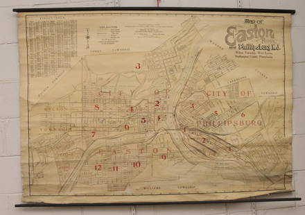
Sold2022MAP OF EASTON, PA AND PHILLIPSBURG, NJ, 1913PRINTED PAPER ON LINEN BACKING WITH PAINTED DOWELS ON TOP/BOTTOM. INTERSTATE MAP COMPANY, NEWARK, NJ 1913. MEASURES 41" X 60" Terms & Conditions: Pick-up for this Auction will be Wednesday August 3rdSee Sold Price
Sold20231894 Rand McNally Railroad Map of New YorkThis is an 1894 Rand McNally and Company Railroad Map of New York. Excellent condition for a 128 year old item! 63 inches by 51 inches. Paper on linen with vibrant colors! Comes with original metal seSee Sold Price
Sold2022Pri-Matic Art Company Order of Battle on the Western Front Map.Description: Pri-Matic Art Company Order of Battle on the Westernront Map. (Armistice Day). Measurement: 21 H x 24 W Material: Paper.See Sold Price
Sold2019AN ANTIQUE MAP, "Orrientalior Districtus MarisAN ANTIQUE MAP, "Orrientalior Districtus Maris Mediterranei, t'Oofter gedeelte van de Middelandse Zee," AMSTERDAM, 1675-1680, hand colored engraving on paper, a page fragment, printed for Orbis MaritiSee Sold Price
Sold2019AN ANTIQUE MAP, "Poli Arctici et CircumiacentiumAN ANTIQUE MAP, "Poli Arctici et Circumiacentium Terrarum Descriptio Novissima," CIRCA 1676, hand colored engraving on paper, published by Frederick de Wit (1630-1706), a banner cartouche U/L, "GedrucSee Sold Price
Sold2019AN VINTAGE MAP, "Texas and Indian Territory," SECONDAN VINTAGE MAP, "Texas and Indian Territory," SECOND QUARTER 20TH CENTURY, color engraving on paper, showing counties, cities, rail lines, and rivers. 13.25" x 10.125"See Sold Price
Sold2018Antique Map - LondonAntique folding map "London in Miniature With The Surrounding Villages, An Entire NEW PLAN …." by Edward Mogg, published by Edward Mogg, No 51 Charing Cross, London made up of 20 paper panels laid dSee Sold Price
Sold2023After Claes Jansz Visscher, Map of ParisAfter Claes Jansz Visscher (Dutch, 1586-1652), engraving on paper depicting a 1618 map of Paris, flanked on either side by illustrations of Parisian citizens from the King and Queen, to the common vilSee Sold Price
Sold2023Xianzhan Wang (Chinese, 19th c.)Xianzhan Wang (Chinese, 19th c.) "Constellation Map Fan Painting", ink and goldleaf on paper mounted to paper, inscribed for Shuping Gu, inscribed and sealed middle left, fan 7 1/8 in. x 20 1/8 in., sSee Sold Price
Sold2019AN ANTIQUE CELESTIAL MAP, "Astronomia Comparativa,"AN ANTIQUE CELESTIAL MAP, "Astronomia Comparativa," NUREMBERG, 1735-1742, hand colored engraving on paper, a page fragment from Atlas Coelestis, plate 30, printed by Homann Heirs, a third generation oSee Sold Price
Sold2019AN ANTIQUE CELESTIAL MAP, "Theoria PlanetarumAN ANTIQUE CELESTIAL MAP, "Theoria Planetarum Primariarum," NUREMBERG, 1716-1724, hand colored engraving on paper, a page fragment from Atlas Coelestis, plate number 4, after Johann Homann (1664-1724See Sold Price
Sold2020A CADASTRAL MAP, "Deaf Smith, General Land Office, Feb.A CADASTRAL MAP, "Deaf Smith, General Land Office, Feb. 10th, 1880," LATE 19TH/EARLY 20TH CENTURY, lithograph on pale pink paper a facsimile after the original, showing the "Capitol Land Reservation,"See Sold Price
Sold2019AN ANTIQUE MAP, "Accuratissima Angliæ Regni et WalliæAN ANTIQUE MAP, "Accuratissima Angliæ Regni et Walliæ Principatus," AMSTERDAM, CIRCA 1680, hand colored engraving on paper, published by Frederick de Wit (1630-1706), showing most of the British IslSee Sold Price
Sold2022AN AMERICAN CIVIL WAR ERA MAP, "United States of North America (Eastern & Central)," LONDON,AN AMERICAN CIVIL WAR ERA MAP, "United States of North America (Eastern & Central)," LONDON, 1861-1873, THEODORE ETTLING (b. 1823), hand colored lithograph on paper, by T. Ettling, published by CasselSee Sold Price
Sold2022A REPUBLIC OF TEXAS MAP, "North America," CHAPMAN & HALL, BRITISH, 1843,A REPUBLIC OF TEXAS MAP, "North America," CHAPMAN & HALL, BRITISH, 1843, hand colored engraving on paper, Published by Chapman & Hall...under the Superintendence of the Society for the Diffusion of UsSee Sold Price
Sold2019AN ANTIQUE SCANDINAVIA MAP, "Novissima nec nonAN ANTIQUE SCANDINAVIA MAP, "Novissima nec non Perfectissima Scandinaviæ, Tabula Comprehendens Regnorum Sueciæ, Daniæ, et Norvegiæ," AMSTERDAM, 17TH/18TH CENTURY hand colored engraving on paper, aSee Sold Price
Sold2019AN ANTIQUE CELESTIAL MAP, "Phænomena MotuumAN ANTIQUE CELESTIAL MAP, "Phænomena Motuum Irregularium quos Planetar inferiores Venus et Mercurius ad annum Salutis MDCCX," NUREMBERG, 1716-1724, hand colored engraving on paper, a page fragment frSee Sold Price
Sold2019AN ANTIQUE MAP, "Map of Oklahoma and Indian Territory,"AN ANTIQUE MAP, "Map of Oklahoma and Indian Territory," 1890-1892, color engraving on paper, copyrighted by Mast, Crowell & Kirkpatrick, with view of Beaver. 10.375" x 13" Note: Showing populations oSee Sold Price
Sold2023Antique German Map of the Holy LandGerman, circa 1730, hand-colored engraving on paper depicting the path of the Children of Israel after their escape from Egypt, 16 1/2" x 20 1/2" sheet size, 21" x 24 1/2" mat size.See Sold Price
Sold2022A FEDERAL PERIOD MAP, "United States," LONDON, CIRCA 1818,A FEDERAL PERIOD MAP, "United States," LONDON, CIRCA 1818, CHARLES SMITH (1803-1864), hand colored copper plate engraving on paper, obscured publisher information in margin, plate 50, probably from SmSee Sold Price
Sold2023Mitchell's National Map, 1858S. Augustus Mitchell's map of the United States, 1858, published in Philadelphia, hand-colored, paper lined with canvas between hanging rods, 64" x 65".See Sold Price
6 days LeftRbfineartsHistorical Map of the State of Kentucky by Karl Smith 1933 Daniel Boone & Companions ViewUS$30(2 bids)
6 days LeftRbfineartsHistorical Map of the Chesapeake Bay By Edwin Tunis Published By The National Brewing Co.US$20(1 bid)
2 days LeftJasper521640 Gerritsz/De Laet Map of Brazil -- Provincia de Brasil cum Adiacentibus ProvinciisUS$320
4 days LeftForum AuctionsStevenson (Robert Louis) Treasure Island, first edition, first issue, 1883.£1,000
Crawford Family Auctions LLCVintage Framed Print of Photograph "Concert for a New Beginning" by Mark Bergasma. See pics.US$20
Jun 06Akiba GalleriesAntique Mast, Crowell, & Kirkpatrick Map Of Texas, California, & NevadaUS$25(1 bid)
7 days LeftGold Coast Auctioneers17th-19th c. French Wall Art Collection Map City Sea Scapes Scenes etc.US$50