Sold2021Early map of the Great Lakes, Midwest region. By Bonne/Title: Early map of the Great Lakes, Midwest region. By Bonne/ Raynal. 1780 Date/Period: 1780 Materials: Copperplate engraved Size: 13 1/2 x 9 3/4 An important and detailed early map of the Great LakeSee Sold Price
Sold20241775-1780 Upper Midwest and Great Lakes region. By Bonne & RaynalTitle: 1775-1780 Upper Midwest and Great Lakes region. By Bonne & Raynal Date/Period: 1775-1780 Materials: Copperplate engraved Size: 14 1/2” x 9 1/2 “ This vintage map, created by R. BonnSee Sold Price
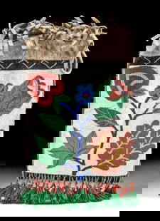
Sold2023Early Winnebago / Ojibwe Beaded Leather PouchNative American / First Nations, Northern United States / Canada, Great Lakes Region & Midwest, Winnebago / Ojibwe, ca. early 20th century CE. A hide bag with beadwork across both sides, the front panSee Sold Price
Sold2023 [MAPS - GREAT LAKES REGION]. VAUGONDY, Gilles Robert de (16...[MAPS - GREAT LAKES REGION]. VAUGONDY, Gilles Robert de (1688-1766). Les Lacs du Canada et Nouvelle Angleterre… Paris, 1749. Engraved map (229 x 318 mm) with hand-colored outlining, appearing toSee Sold Price
Sold2023Early Firehouse Postcards, Great Lakes Region - 49 [163509]Early Great Lakes Region State Firehouse Postcards (49). All are in color and have apparatus and horses on display Illinois (6). Wisconsin (5). Indiana (11). Ohio (12). Michigan (15) No Duplicates. 19See Sold Price
Sold2016Influential map of Great Lakes region 1755Heading: Author: Bellin, Jacques Nicolas Title: Partie Occidentale de la Nouvelle France ou du Canada Place Published: Nuremberg Publisher:Homann Heirs Date Published: 1755 DescriptionSee Sold Price
Sold20211754 Bellin Map of the Great Lakes Region -- Carte desTitle: 1754 Bellin Map of the Great Lakes Region -- Carte des Lacs du Canada pour Servir a l'Histoire Generale des Voyages Cartographer: J Bellin Year/Place: 1754 c., Paris Map Dimensions (in.): 7.7 XSee Sold Price
Sold20191754 Bellin Map of the Great Lakes Region -- Carte desTitle: 1754 Bellin Map of the Great Lakes Region -- Carte des Lacs du Canada pour Servir a l'Histoire Generale des Voyages Date: 1754 c., Paris Medium: JBellin Size: 7.7 X 11.4 in. Additional InformatSee Sold Price
Sold20241920s Native American Chippewa Beaded Leather Bag**Originally Listed At $300** First Nations / Native American, Midwestern United States / Canada, Great Lakes Region & Midwest, Chippewa / Ojibwe, ca. 1920s to 1930s CE. A fringed hide drawstring bagSee Sold Price
Sold2018Map of the Basin of the St. Lawrence.[Map] Keefer, Thomas C. Map of the Basin of the St. Lawrence. New York: Ackerman Litho., 1853. Hand-colored map depicting the Great Lakes Region for Isreal de Wolf Andrew’s report for the TreasuSee Sold Price
Sold2021North American Great Lakes Copper ArrowheadEarly North American Great Lakes region copper arrowhead or point. Keywords: Prehistoric, Pre-Columbian. Length: 5 in x width: 1 1/2 in x depth: 1/4 in.See Sold Price
20181719 Chatelain Map of Eastern Canada and Great LakesTitle/Content of Map: 1719 Chatelain Map of Eastern Canada and Great Lakes Region -- Carte du Canada ou de la Nouvelle France & Des Decouvertes qui y ont ete Faites, Dresse sur les observations les plSee Sold Price
Sold20191719 Chatelain Map of Eastern Canada and Great LakesTitle/Content of Map: 1719 Chatelain Map of Eastern Canada and Great Lakes Region -- Carte du Canada ou de la Nouvelle France & Des Decouvertes qui y ont ete Faites, Dresse sur les observations les plSee Sold Price
Sold2022(CANADA.) Guillaume de L'Isle. Carte du Canada ou de la Nouvelle France.(CANADA.) Guillaume de L'Isle. Carte du Canada ou de la Nouvelle France. Double-page engraved map of eastern Canada and the Great Lakes region with a fine figural title cartouche in the blank northwesSee Sold Price
Sold2021Maps of North America, California, and the Great LakesMaps of North America, California, and the Great Lakes RegionSee Sold Price
Sold2019Partie Occidentale du Canada Great Lakes Midwest.Reserve Reduced! TITLE/CONTENT OF MAP: 'Partie Occidentale du Canada et Septentrionale de la Louisiane avec une Partie de la Pensilvanie par le Sr. d'Anville de l'Academie Rle. des Inscriptions et BelSee Sold Price
Sold2021[GREAT LAKES REGION]. ROBERT DE VAUGONDY, Didier[GREAT LAKES REGION]. ROBERT DE VAUGONDY, Didier (1723–1786). Partie De l’Amerique Septent? qui comprend La Nouvelle France ou Le Canada. Paris, 1755. Hand–colored engraved map of eaSee Sold Price
Sold2017Bonne: Map of the Great Lakes, 1880Map: 1880 Bonne Map of the Great Lakes -- Partie Occidentale du Canada, contenant les cinq Grands Lacs, avec les Pays Circonvoisins Cartographer: R. Bonne Year / Place: 1780 Paris Map Dimensions: 8.3See Sold Price
Sold20181780 Bonne Map of the Great Lakes -- Partie OccidentaleTitle/Content of Map: 1780 Bonne Map of the Great Lakes -- Partie Occidentale du Canada Contenant les Cinq Grands Lacs, avec les Pays Circonvoisins Date Printed: 1780, Paris Cartographer: R. Bonne SizSee Sold Price
Sold2022[GREAT LAKES REGION]. A pair of engraved maps, including: T...[GREAT LAKES REGION]. A pair of engraved maps, including: TANNER, Henry Schenk. North America: Sheet V The Northwest and Michigan Territories. London Baldwin & Cradock, 1833. Hand–outlined in coSee Sold Price
2022Jacques-Nicolas Bellin (1703-1772), After - Map of Great Lakes 1770Carte des Lacs du Canada Engraved map from the Dutch edition of Bellin's Histoire General des Voyages. Original hand-coloring; fairly foxed, most with an early ink annotation at lower margin. AmsterdaSee Sold Price
Sold2023Great early map of Iowa by Cowperthwait, 1850Early and desirable map of Iowa, hand colored by counties, showing railroads, stage lines, canals, forts, towns, roads, rivers, lakes and more. Possibly one of the very best early maps of this state.See Sold Price
Sold2021Great early map of Iowa by Cowperthwait, 1855Early and desirable map of Iowa, hand colored by counties, showing railroads, stage lines, canals, forts, towns, roads, rivers, lakes and more. Possibly one of the very best early maps of this state.See Sold Price
Sold2024Homann Map of New Spain 1720HOMANN, Johann Baptista (1664-1724). Regni Mexicani seu Novae Hispaniae. Engraved map. Nuremberg, 1720. 20" x 23 1/2" sheet. This superb map covers the region from the Great Lakes and Nova Scotia throSee Sold Price
Jun 07Freeman's | HindmanHOMANN, Johann Baptist. Amplissimae Regionis Mississipi Seu Provinciae Ludovicianae. Nuremburg, [caUS$400
May 21Jasper521879 Powell Map of Utah -- Map of Utah Territory Representing the Extent of the Irrigable, TimberUS$120
3 days LeftZiebarth's Gallery19th Century Oil On Canvas of Little Girl Plus a Northwoods Painting of Lake & Elk On Artist BoardUS$10
Jun 01Black Hills Curio CompanyGreat lakes c1910-1930 Native American Pictorial Deer Head & Geometric Design Bag - Loom BeadedUS$100
2 days LeftPotter & Potter AuctionsMap to Acquaint You with the Great Mission Bay Project. 194...US$125(1 bid)
32 mins LeftJasper521858 Mitchell Map of Great Britain and Ireland [verso] Germany and Switzerland -- No. 22 Map ofUS$25
May 21Jasper521692 Peeters Map of Southeast France -- Ducatus Saboudiae Principatus Pedemontii ComitatusUS$70
Featured32 mins LeftJasper521720 c. Homann Map of Southern Belgium -- Comitatus Hannoniae in Suas Quasque CastellaniasUS$60


![[MAPS - GREAT LAKES REGION]. VAUGONDY, Gilles Robert de (16...: [MAPS - GREAT LAKES REGION]. VAUGONDY, Gilles Robert de (1688-1766). Les Lacs du Canada et Nouvelle Angleterre… Paris, 1749. Engraved map (229 x 318 mm) with hand-colored outlining, appearing to](https://p1.liveauctioneers.com/928/301544/160920958_1_x.jpg?height=310&quality=70&version=1694462960)
![Early Firehouse Postcards, Great Lakes Region - 49 [163509]: Early Great Lakes Region State Firehouse Postcards (49). All are in color and have apparatus and horses on display Illinois (6). Wisconsin (5). Indiana (11). Ohio (12). Michigan (15) No Duplicates. 19](https://p1.liveauctioneers.com/2699/291514/154451446_1_x.jpg?height=310&quality=70&version=1686010181)


![Map of the Basin of the St. Lawrence.: [Map] Keefer, Thomas C. Map of the Basin of the St. Lawrence. New York: Ackerman Litho., 1853. Hand-colored map depicting the Great Lakes Region for Isreal de Wolf Andrew’s report for the Treasu](https://p1.liveauctioneers.com/928/124137/63148817_1_x.jpg?height=310&quality=70&version=1530051387)


![[GREAT LAKES REGION]. ROBERT DE VAUGONDY, Didier: [GREAT LAKES REGION]. ROBERT DE VAUGONDY, Didier (1723–1786). Partie De l’Amerique Septent? qui comprend La Nouvelle France ou Le Canada. Paris, 1755. Hand–colored engraved map of ea](https://p1.liveauctioneers.com/928/212515/108628837_1_x.jpg?height=310&quality=70&version=1627420959)


![[GREAT LAKES REGION]. A pair of engraved maps, including: T...: [GREAT LAKES REGION]. A pair of engraved maps, including: TANNER, Henry Schenk. North America: Sheet V The Northwest and Michigan Territories. London Baldwin & Cradock, 1833. Hand–outlined in co](https://p1.liveauctioneers.com/928/252933/131521733_1_x.jpg?height=310&quality=70&version=1656110480)


![1858 Mitchell Map of Great Britain and Ireland [verso] Germany and Switzerland -- No. 22 Map of (1 of 2)](https://p1.liveauctioneers.com/5584/328338/176911589_1_x.jpg?height=282&quality=70&version=1715113718)


