Sold2024Antique Map - Colossus Monarchic. Statua Danielis SEUTTER Matthaus 1707One from the set of four famous cartographic curiosities by Seutter. The series of impressive copper engravings intended to serve as a serious instructional aid by illustrating geographical terms., puSee Sold Price
Sold2024Antique Map - Colossus Monarchic. Statua Danielis SEUTTER, Matthaus 1707One from the set of four famous cartographic curiosities by Seutter. The series of impressive copper engravings intended to serve as a serious instructional aid by illustrating geographical terms.See Sold Price
Sold2022Emanuel Eichel (1717-1782), After August SchellerEmanuel Eichel (1717-1782), After August Scheller Emanuel Eichel (1717-1782), After August Scheller 'Tobias Conrad Lotter, Statua Regum Europaeorum P.C.N. Nomina Continens' hand coloured copper engravSee Sold Price
Sold2023Seutter - Map of North America including Great Lakes, Florida, Virginia, New England, Mexico, WestThis engraving is from a composite atlas presented by the Homann Heirs. Many of the maps in the collection were completed by J. B. Homann, Homann Erben, M. Seutter, and T. C. Lotter. The maps were oriSee Sold Price
Sold2018Seutter: Antique Map of the World, 1740Title/Content of Map: World by Seutter Date Printed: c1740 Cartographer: Matthaus Seutter Material/Medium: Paper Size: 24" x 19 1/2" Original hand colored Copperplate engraved. Published in Augsburg iSee Sold Price
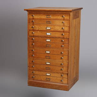
Sold2020Eight Drawer Oak Map, Art or Print File Cabinet, C 1910An antique map, art or print fining cabinet offers oak construction with eight drawers, brass pulls throughout, c1910. Measures- 45.5" H x 28" W x 22.75" D. ***IN-HOUSE SHIPPING & DELIVERY QUICK QUOTESee Sold Price
Sold2020Early Antique Oak 60- Drawer Type-Setting Print CabinetAn early antique type-setting, map or print cabinet offers paneled oak construction with 60 drawers, c1900.Measures- 53.5" H x 49" W x 21" D. ***IN-HOUSE SHIPPING & DELIVERY QUICK QUOTES AVAILABLE UPOSee Sold Price
Sold20241740 RUSSIA antique MAP 21 x 25" Matthaeus Seutter Mappae Imperii MoscoviticiMatthaeus Seutter Mappae Imperii Moscovitici circa 1740 Size overall 21 x 25 in. 100% original Very good condition Reserve: $194.00 Shipping: Domestic: Flat-rate of $25.00 to anywhere within the cSee Sold Price
Sold20241717 MAP of AMERICA antique authentic CALIFORNIA AS AN ISLAND L'AmeriqueAmericas. L'Amerique, Meridionale et Septentrionale Dressee Selon les Dernieres Relations et Suivant les Nouvelles Decouverte... by Fer (Nicholas de) (1646-1720) engraver Inselin, C. A Paris :b Chez lSee Sold Price
Sold2018Oversized Industrial Commercial Oak Map Print CheOversized Industrial Commercial Oak Map Print Chest. Metal handles, panel sides. Antique.-- Dimensions: H: 65.5 inches: W: 63 inches: D: 25 inches ---See Sold Price
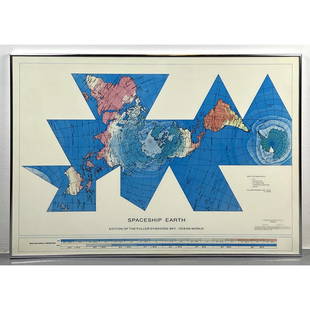
Sold2023Richard Buckminster Fuller Dymaxion World Map Print, 1980 FullerRichard Buckminster Fuller Dymaxion World Map Print, 1980 Fuller Dimensions: H: 22.5 inches: W: 34.5 inches --- -- We offer curbside delivery to NYC, Manhattan, Close Brooklyn, Hoboken about a week afSee Sold Price
Sold2024Matthaus Merian 1627 Antique Map Engraving "Virginia" from Theodore de Bry's "Grand Voyages" #1Antique 1627 map of Virginia by Matthaus Merian after John Smith's 1612 map, from Theodore de Bry's "Grand Voyages". Please see "The Philidelphia Print Shop" sheet shown in final photo. Good conditionSee Sold Price
Sold2023Collection of Antique Prints "Cities of the World"Antique prints and etchings depicting "Cities of the World" - including Harper's Weekly illustrations, landscapes, antique maps, depictions of notable landmarks and famous cities such as Paris, New YoSee Sold Price
Sold2023Assorted Antique Greco-Roman Prints & EngravingsAntique 18th-20th Century Greco-Roman prints and engravings, including Classical depictions of figures and architecture; antique maps; arts and design; anatomical drawings; and more. Approximately 75See Sold Price
Sold2017Lot of 6 Antique Celestial MapsLot of 6 Antique Celestial Maps. Inscribed "Drawn by W. Newton - W. Clarke Arch." These prints are further inscribed "Edward Stanford - London (publisher)". Dated "Noanno 1830". They remain in very niSee Sold Price
Sold20231782 COPPERPLATE ENGRAVED MAP OF EUROPEOriginal antique copperplate engraved map of “Europe” engraved for Baldwins New Complete and Universal System of Geography. Published by Thomas Conder circa 1782.Professionally framed andSee Sold Price
Sold2021Merian Antique Botanical Insect Print Set (6)Maria Sibylla Merian (1647-1717). 6 natural history prints. Flowers butterflies. Metamorphosis Insectorum Surinamensium. Amsterdam: 1705. Hand-colored engravings. Early manuscript scientific notes inSee Sold Price
Sold2022Large Antique French 1748 D'anville Map of South America in a set of 3Jean-Baptiste Bourguignon d’Anville (1697-1782) was one of the foremost French geographers of the eighteenth century. He carried out rigorous research in order to create his maps, which greatlySee Sold Price
Sold2024De Jode, Rare, pub. 1593 - Map of the Holy Land (Descriptio Et Situs Terrae Sanctae Alio NomineThis map of the Holy Land is entitled Descriptio Et Situs Terrae Sanctae Alio Nomine Palestina Multis Preclaris Historys Et Miraculis Utriusque Testamenti A Christo Salvatore nobilitata. The map is beSee Sold Price
Sold2016Map of Bermuda, by Hondius 1633Map of Bermuda, by Hondius 1633. Original hand colored copper engraving. Showing the "tribes" that were granted by the gentleman onboard the shipwreck that force the European settlement of the island.See Sold Price
Sold2024De Jode, Rare, pub. 1593 - Map of Kingdom of Napoli, Italy (Neapolitani Regni exacta ac diligensThis truly significant map is from one of the rarest atlases ever published, Gerard and Cornelis de Jode's Speculum orbis Terrae. The work was published in Antwerp in 1593 by Arnold Coninx for the widSee Sold Price
Sold2024Ptolemy & Magini, pub. 1620 - Double Hemisphere Map of the WorldThis early map engraving is from Claudius Ptolemaeus (Ptolemy) and Giovanni Antonio Magini's Geografia cio? Descrittione Universale della Terra Partita in due volumni, Nel Primo de' quali si contengonSee Sold Price
Sold2024De Jode, Rare, pub. 1593 - Map of Germany (Germaniae Totius, Nostrae Europae celeberrimae regionis,This truly significant map is from one of the rarest atlases ever published, Gerard and Cornelis de Jode's Speculum orbis Terrae. The work was published in Antwerp in 1593 by Arnold Coninx for the widSee Sold Price
Sold2024Kohler & Weigel - Map of the World with North and South Pole viewsThis originally hand-colored engraving is from Johnn David Kohler's Schul- und Reisen-Atlas aller zu Erlernung der alten, mittlern und neuen Geographie dienlichen Universal- und Particular-Charten...See Sold Price
2 days LeftSimpson Galleries, LLC.MATTHAUS SEUTTER (1678-1757) A MAP OF THE HOLY LAND AND TWELVE TRIBES, "Terra Sancta Vocatta QueUS$150(1 bid)
Jun 15Riverfront Auctions'1785 Bocage Map of the City of Athens in Ancient Greece' Par M. Barbié du BocageUS$5(1 bid)
Crawford Family Auctions LLCFramed print of Map of Part of the Island of Hawaii & Sandwich Islands, w/COAUS$20(1 bid)
2 days LeftTrillium Antique Prints & Rare BooksKohler & Weigel - Map of Louisiana Territory or Eastern United States (extends from New Mexico toUS$120(4 bids)
2 days LeftTrillium Antique Prints & Rare BooksSanson - Map of North America with California as an IslandUS$130(4 bids)
2 days LeftTrillium Antique Prints & Rare BooksSanson - Map of California as an Island, Mexico (Audience de Guadalajara)US$160(4 bids)
2 days LeftTrillium Antique Prints & Rare BooksKohler & Weigel - Map of Sicily and SardiniaUS$85(2 bids)