Sold2019Delamarche, Felix 1829 Group of 3 Maps of EuropeEurope at the time of the Charlemagne Empire and Invasions of the Barbarians. Copper Engraved Maps Published 1829, Paris for "Atlas de La Geographie..." by Felix Delamarche. Contemporary outline handSee Sold Price
Sold2019Delamarche, Felix 1829 Pair of Maps. Europe Charlemagne"L'Europe a l'Epoque du demembrement de l'Empire de Charlemagne" and "L'Europe divisee en ses differens Etats sous Charlemagne" Copper Engraved Maps Published 1829, Paris for "Atlas de La Geographie..See Sold Price
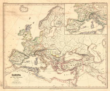
Sold2018Menke: Antique Map of Europe at time of OdovacarsTitle/Content of Map: Europa Zur Zeit Odovacars (476-493.) Date Printed: 1874 Cartographer: MENKE, TH. Publisher: JUSTUS PERTHES 1874 GOTHA Size: Quarto – 12.80 H x 15.75 W Inches "Von Th. Menke..."See Sold Price
Sold2016Map of Empire of Charlemagne. Europe. 1854.Print of hand colored steel engraving titled „Carte du Partage de L’Empire de Charlemagne“.Drawn by L. Dussieux.Engraved by unknown.From „Atlas General De Geographie physique, politique et hisSee Sold Price
Sold2023Central Europe. Germany Poland Czechoslovakia Carpathian Ruthenia TIMES 1922 mapTITLE/CONTENT OF MAP: 'Central European states - Political' Czechoslovakia includes Carpathian Ruthenia, which it administered until it was occupied and annexed by Hungary in 1939; it was subsequentlySee Sold Price
Sold2023Eastern Europe Italian Albania Czechosolvakia Carpathian Ruthenia TIMES 1922 mapTITLE/CONTENT OF MAP: 'Eastern Europe - Communications' Czechoslovakia includes Carpathian Ruthenia, which it administered until it was occupied and annexed by Hungary in 1939; it was subsequently occSee Sold Price
Sold2023EUROPE/HOLY ROMAN EMPIRE. at the time of the Third Crusade 1190 1902 old mapTITLE/CONTENT OF MAP: 'Europe at the time of the Third Crusade 1190' DATE PRINTED: 1902 IMAGE SIZE: Approx 25.0 x 34.0cm, 9.75 x 13.5 inches (Large) TYPE: Antique colour map. This map was published inSee Sold Price
Sold2023HOLY ROMAN EMPIRE. Europe. Otto the Great 962. Spread of Christianity 1902 mapTITLE/CONTENT OF MAP: 'Europe at the time of the Restoration of The Empire in the West by Otto the Great 962; Inset map of Spread of Christianity about the year 1000' DATE PRINTED: 1902 IMAGE SIZE: ApSee Sold Price
Sold2021Europe In Napoleon's Time 1897Title/Content of Map: Europe In Napoleon's Time 1897 Date Printed: 1897 Cartographer: I.S. Clare Material/Medium: Paper Size: approx. 11x14 inches Additional Info: Cram's Universal Atlas Reserve: $30.See Sold Price
Sold2024HOLY ROMAN EMPIRE. Europe. Otto the Great 962. Spread of Christianity 1902 mapTITLE/CONTENT OF MAP: 'Europe at the time of the Restoration of The Empire in the West by Otto the Great 962; Inset map of Spread of Christianity about the year 1000' DATE PRINTED: 1902 IMAGE SIZE: ApSee Sold Price
Sold2024Eurasia. Europe & Asia political & relief. USSR. Trucial Oman. TIMES 1959 mapCAPTION PRINTED BELOW PICTURE: 'Eurasia' DATE PRINTED: 1959 IMAGE SIZE: Approx 47.5 x 59.5cm, 18.75 x 23.5 inches (Large); Please note that this is a folding map. TYPE: Vintage coloured map CONDITION:See Sold Price
Sold2019Delamarche, Felix 1829 Lot of 3 Maps. Europe & Germany"L'Europe a l'Epoque du demembrement de l'Empire de Charlemagne" "L'Europe avan l'Invasion des Barbares" and "Germania Antiqua et regiones Danubium" Copper Engraved Maps Published 1829, Paris for "AtlSee Sold Price
Sold2021Framed 17th C. German Engraved Map of France**First Time At Auction** Europe, German, 17th century. "Das Konigreich Franckreich" (The Kingdom of France) Nova Gallia Tabula - copper plate engraving, ca. 1630. A finely engraved map of the KingdomSee Sold Price
Sold201919th C. French Map - The Port of Vera Cruz Mexico100% of the Hammer price of all lots sold in this auction will be donated to Community Food Share by Artemis Gallery. $1.00 = 3 meals! **First Time At Auction** Europe, France, ca. 19th century CE.See Sold Price
Sold2019The Times 1895 Lot of 8 Maps of EuropeIncl Ethnographic Map of Europe, Holland, Belgium and Luxemburg, Denmark, Alsace/Bavaria, Ethnographic Map of Austria-Hungary, Hungary, and Norway/Sweden. Lithograph Maps Published 1895, London for "TSee Sold Price
Sold2019The Times 1895 Lot of 7 Maps of EuropeIncl Constantinople, Religions of Europe, Ethnographic Map of the Balkan Peninsula, Greece, Southern Scandinavia, Mediterranean Sea, and General Map of the Alps. Lithograph Maps Published 1895, LondonSee Sold Price
Sold2022Times Atlas 1895 Lot of 11 Maps of EuropeIncl Hungary, Bohemia, Mediterranean, Greece, Caucasus, Ireland, Holland, Belgium/Luxemburg, South Scandinavia, and Sweden/Norway. Lithograph Map Published 1895, London for "The Times Atlas" Two withSee Sold Price
Sold2019Bartholomew, John 1922 Lot of 4 Large Maps of EuropeLarge Lithograph Maps Published 1922 by The Times, London for "The Times Survey Atlas of the World" Maps by John George Bartholomew of the Edinburgh Geographical Institute. Centre fold as issued. PapeSee Sold Price
Sold2019The Times 1895 Lot of 8 European MapsIncl German States, France, Europe Continent, Austria-Hungary and European Russia. Lithograph Maps Published 1895, London for "The Times Atlas" Paper Size: 21 x 16.5 inch (54 x 42cm) A couple with minSee Sold Price
Sold2019Bartholomew, John 1922 Lot of 8 Large Maps of EuropeIncl Belgium/Holland, Spain/Portugal - East & West, Northern Italy/Austria, Southern Italy, Central European States, Germany - South & West. Large Lithograph Maps Published 1922 by The Times, London fSee Sold Price
Sold2021Bartholomew, John 1922 Lot of 4 LG Maps of EuropeLarge Lithograph Maps Published 1922 by The Times, London for "The Times Survey Atlas of the World" Maps by John George Bartholomew of the Edinburgh Geographical Institute. Centre fold as issued. PapeSee Sold Price
Sold2019Bartholomew, John 1922 Lot of 4 Maps of EuropeIncl Europe Political, Eastern Europe Political, Western Europe Political, and Europe Physical Features & Population. Large Lithograph Maps Published 1922 by The Times, London for "The Times Survey AtSee Sold Price
Sold2020Bartholomew, John 1922 Lot of 4 Large Maps. EuropeIncl Europe Political, Orography/Vegetation/Races/Population, Western Europe Politcal, Eastern Political. Large Lithograph Maps Published 1922 by The Times, London for "The Times Survey Atlas of the WSee Sold Price
Sold2020Bartholomew, John 1922 Lot of 4 Maps. EuropeIncl Europe Political, Orography/Vegetation/Races/Population, Western Europe Political, and Eastern Europe Political. Large Lithograph Maps Published 1922 by The Times, London for "The Times Survey AtSee Sold Price
2 days LeftJasper52Central America and West Indies. Nicaragua & Panama Canal. THE TIMES 1900 mapUS$30
2 days LeftJasper52Antilles. West Indies Cuba Jamaica Hispaniola Caribbean islands TIMES 1895 mapUS$40
6 days LeftGlobal Auctions CompanyHand Colored Engraved Map of Europe, Jean Baptiste Bourguignon Anville 1754US$450
22 hrs LeftBonhamsTULP, NICOLAES. 1593-1674. Observationum medicarum libri tres. Amsterdam: Lodewijk Elzevir, 1641.US$500
2 days LeftJasper52West Indies & Caribbean. Panama Canal. Relief. THE TIMES 1922 old antique mapUS$20
Jul 16BADO e MART AUCTIONSWorld Map. Plate with 18 time zones to construct a Terrestrial Globe.€2,500