Sold2024Exact Plan of Lisle,Title: Exact Plan of Lisle, Publication Date: c1708 Cartographer: BRODRICK, THOS./J. HARRIS Publisher: Height: 7 Width: 8.75 "is humbly dedicated to his Grace the Duke of Ormond by his Grace's most faSee Sold Price
Sold2020Netherlands 1747 Antique Map. Bergen-Op-Zoom"A New and Exact Plan of the Town and Fortifications of Bergen-Op-Zoom" Copper Engraved Map Published 1732-85, London for "The London Magazine" Folds as issued. Paper Size: 10.5 x 8 inch (27 x 20cm) GSee Sold Price
Sold2017Didot: Antique Plan de l’Isle de Goree, 1747Map: Plan de l’Isle de Goree, sur les desseins du Sr. Compagnon Publication Date: 1747 Authors: Didot, Compagnon with Tardieu, sc. Publisher: Didot Size: Double Octavo – 7.6 H x 14.25 W Inches No.See Sold Price
Sold20231764 Bellin Map of Vache Island South of Haiti -- Plan de l'Isle a Vache a la Coste du Sud de S.Title: 1764 Bellin Map of Vache Island South of Haiti -- Plan de l'Isle a Vache a la Coste du Sud de S. Domingue Cartographer: J Bellin Year / Place: 1764, Paris Map Dimension (in.): 8.4 X 6.4 in. ThiSee Sold Price
Sold2017Bellin: Plan De L’Isle a Vache, 1764“Plan De L’Isle a Vache a la Coste du Sud de S. Domingue”, by J.N. Bellin, 1764 from “Le Petit Atlas Maritime…”. Fine, tinting, in matting and tagged to top margin, measures 9 x 12”. PleSee Sold Price
Sold2018Calmet: Antique Map of Malta, St Paul’s Shipwreck, 1728Map: Ancien Plan de l'Isle de Malte, ou S. Paul Aborda apres son Naufrage, Act XXVIII Cartographer: Calmet Place & Date: Paris / 1728 Size: 17" x 12" Condition: b&w; light overall age toning The verySee Sold Price
Sold2023Delisle Map of Paris, France, Hand Colored 1716Important Map of Paris by Guillaume De L'Isle, Full Title: Plan de la Ville et Fauxbourgs de Paris. Dressee sur les observations astronomiques de l'Academie Royale des Sciences et sur les operations gSee Sold Price
Sold2019Carte de l'isle O-Taïti. Tahiti, Moorea & Marquesas.TITLE/CONTENT OF MAP: '[Cook 3e Voyage] Carte de l'isle O-Taïti // Plan des Havres, situés au côté Nord d'Eimeo // Baye Matavai dans O-Tahïti // Carte des Marquises de Mendoce [Cook's 3rd VoyageSee Sold Price
Sold20221764 Bellin Map of Cap Haitien Bay in Haiti -- Plan du Port du Cap dans l'Isle de St. DomingueTitle: 1764 Bellin Map of Cap Haitien Bay in Haiti -- Plan du Port du Cap dans l'Isle de St. Domingue Cartographer: J Bellin Date/Place: 1764, Paris Dimensions: 9.1 X 14.1 in. Description: This handsoSee Sold Price
Sold2019Carte de la rivière de Cook. Cook Inlet & Alaska coast.TITLE/CONTENT OF MAP: '[Cook 3e Voyage] Carte de la rivière de Cook, dans la partie Nord-Ouest de l Amérique // Plan du Havre de Samgano odha, dans l'Isle de Oonalaska [Cook's 3rd Voyage - Map of CoSee Sold Price
Sold2017Bellin: Antique Map of Santiago de Cuba Bay, 1764Map: Plan de la Baye St. Yago dans l'Isle de Cube Cartographer: Bellin Place & Date: Paris / 1764 Size: 6 1/4" x 8 1/4" Condition: wash color; light overall age toning, very light water stain in wideSee Sold Price
Sold2018Bellin: Antique Plan of Santiago, Cuba, 1764Map: Plan de la Baye St. Yago dans l'Isle de Cube Cartographer: Bellin Place & Date: Paris / 1764 Size: 6 1/4" x 8 1/4" Condition: wash color; a beautifully preserved exemplar Bellin's charming plan oSee Sold Price
Sold20221764 Bellin plan of Cap Haitien, Haiti -- Ville du Cap dans l'Isle de St. DomingueTitle: 1764 Bellin plan of Cap Haitien, Haiti -- Ville du Cap dans l'Isle de St. Domingue Cartographer: J Bellin Year / Place: 1764, Paris Map Dimension (in.): 8.8 X 13.8 in. This is a bird's-eye planSee Sold Price
Sold2017Bellin: Plan Du Port Carenage, 1763Map Title: Plan Du Port Carenage ou Petit Cul De Sac De L’Isle Se Lucie Maker: Jacques Bellin Printed in Paris Date: Circa 1763 Dimensions: 9 x 11.5 inches Jacques-Nicolas Bellin(1703-1772) was a FrSee Sold Price
Sold2021Bellin, Jacques-Nicolas - Plan du port et ville deBellin, Jacques-Nicolas (1703-1772) Plan du port et ville de Louisbourg dans l'Isle royale (1744) Description: P.N.B. Ing. de la M. 1744. Extract from the Petit atlas maritime published in Paris in 17See Sold Price
Sold20231764 Bellin Map of Castries in St. Lucia, Lesser Antilles -- Plan du Port du Carenage ou Petit CulTitle: 1764 Bellin Map of Castries in St. Lucia, Lesser Antilles -- Plan du Port du Carenage ou Petit Cul de Sac de l'Isle Se Lucie Cartographer: J Bellin Year / Place: 1764, Paris Map Dimension (in.)See Sold Price
Sold20221764 Bellin Map of Castries, St Lucia in Lesser Antilles -- Plan du Port et du Carenage de CariacouaTitle: 1764 Bellin Map of Castries, St Lucia in Lesser Antilles -- Plan du Port et du Carenage de Cariacoua Situe dans la Partie du Sud de l'Isle de St. Vincent Cartographer: J Bellin Date/Place: 1764See Sold Price
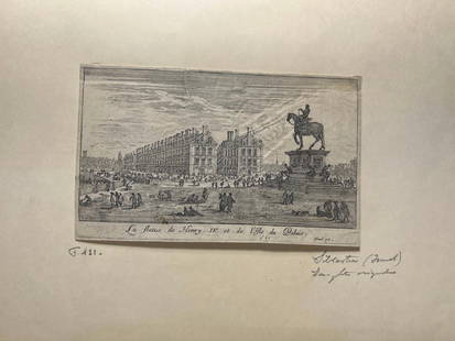
Sold2024'La statue de Henry IV et l'Isle du Palais' Copperplate Engraving, c. 1621France, 17th century. A copperplate engraving by Israel Silvestre (1621-1691). On lined paper with a watermark, partially of a heart. Exact copies held by the Royal Collection Trust and the Louvre. MSee Sold Price
Sold2016Callejo Y Angulo, Description de l'Isle de SicileCallejo Y Angulo Pierre (del), Description de l'Isle de Sicile, et de ses cotes maritimes, avec les plans de toutes ses forteresses... Amsterdam: Wetstein & G. Smith, 1734. In-8° (mm 193x113). PagSee Sold Price
Sold2024Barthelemy, Jean 1790 Map. Greece - L'Attique la Megaride et Partie de L'Isle d'EubeeCopper Engraved Map Published 1790, Paris for "Recueil de Cartes Geographiques, Plans, Vues et Medailles de L'Ancienne Grece, Relatifs Au Voyage du Jeune Anacharsis" by Jean Jacques Barthelemy. CentreSee Sold Price
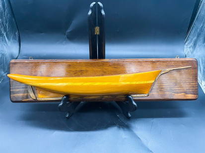
Sold2022Mounted Ship Half Hull From Nautical Art EstateA Carved Wooden Half Hull Model Ship. Half Hulls are exact models of ships hulls, without the mast and rigging, that were used by shipwrights to plan the design of the ship and make sure everything waSee Sold Price
Sold20171764 Map of Port At St. Vincent BellinCopper Plate Engraved Map “plan Du Port Et Du Carenage De Cariacoua Situe Dans La Partie Du Sud De L'isle De St. Vincent”, Bellin's "le Petit Atlas Maritime, Ou Recueil De Cartes Et De Plans Des QSee Sold Price
Sold2022[Americana] (Ellicott, Andrew) Russell, J(ohn). (engraver) Plan of the City of Washington, in the[Americana] (Ellicott, Andrew) Russell, J(ohn). (engraver) Plan of the City of Washington, in the Territory of Columbia, ceded by the States of Virginia and Maryland to the United States of America...See Sold Price
6 days LeftJasper52Détroit de Magellan. Strait of Magellan. Chile. BONNE 1790 old antique mapUS$30
6 days LeftJasper52Détroit de Magellan. Strait of Magellan. Chile. BONNE 1788 old antique mapUS$30
Jun 05Lion Heart AutographsMagnificent Signed Frank Lloyd Wright Architectural Plan for the Wilson Shelton HouseUS$2,000
Jun 05Lion Heart AutographsSigned Frank Lloyd Wright Architectural Plan and Drawings for the Gillin House in DallasUS$1,800
Jun 07Freeman's | Hindman[MAP]. SARTINE, Antoine Plan de la Barre et du Havre de Charles-Town...1778. RARE REVOLUTIONARY WARUS$1,000(1 bid)
4 days LeftLuther AuctionsAlbert Meda for Luce Plan Berenice - Italy - table lamp with Ikea converter (not working)US$100
6 days LeftForum AuctionsJudaica.- Israeli Defense Force (Educational Department) [Plan of The Temple Mount, or Haram£400
Jun 08AUTOMOBILIA LADENBURG AUCTIONmixed lot with 7 pieces, among it racing flyers with route plan Grand Prix Belgium 1966, race€50
5 days LeftJasper52VERY RARE. Washington D.C. Plan for Reclamation of the Marshes. From a Supreme Court Exhibit,US$400
5 days LeftJasper521874 Holmes Plan of New York's Upper East Side -- Map of the Common Lands from 76th to 93rd StreetUS$750
6 days LeftForum AuctionsLondon, Whitechapel.- Manning (Joseph, surveyor) A Plan of an Estate situate in the Parish of St£600
6 days LeftBidhausChristian Dior Dior Women's Tote Bag Plan de Paris Book Medium Jacquard Canvas Black EmbroideryUS$620(2 bids)


![Carte de l'isle O-Taïti. Tahiti, Moorea & Marquesas.: TITLE/CONTENT OF MAP: '[Cook 3e Voyage] Carte de l'isle O-Taïti // Plan des Havres, situés au côté Nord d'Eimeo // Baye Matavai dans O-Tahïti // Carte des Marquises de Mendoce [Cook's 3rd Voyage](https://p1.liveauctioneers.com/5584/154902/78199490_1_x.jpg?height=310&quality=70&version=1574201574)

![Carte de la rivière de Cook. Cook Inlet & Alaska coast.: TITLE/CONTENT OF MAP: '[Cook 3e Voyage] Carte de la rivière de Cook, dans la partie Nord-Ouest de l Amérique // Plan du Havre de Samgano odha, dans l'Isle de Oonalaska [Cook's 3rd Voyage - Map of Co](https://p1.liveauctioneers.com/5584/147595/74587318_1_x.jpg?height=310&quality=70&version=1565730371)


![[Americana] (Ellicott, Andrew) Russell, J(ohn). (engraver) Plan of the City of Washington, in the: [Americana] (Ellicott, Andrew) Russell, J(ohn). (engraver) Plan of the City of Washington, in the Territory of Columbia, ceded by the States of Virginia and Maryland to the United States of America...](https://p1.liveauctioneers.com/65/259470/135047466_1_x.jpg?height=310&quality=70&version=1661539042)


![[MAP]. SARTINE, Antoine Plan de la Barre et du Havre de Charles-Town...1778. RARE REVOLUTIONARY WAR (1 of 1)](https://p1.liveauctioneers.com/197/329395/177650540_1_x.jpg?height=282&quality=70&version=1715364962)


