Sold2024Excellent example 1852 Map of the State of TexasVery clean, comprehensive map of Texas, showing the new boundaries after the Compromise of 1850, with inset maps of the panhandle and Galveston. Locates Apaches in the western part of the state, ComanSee Sold Price
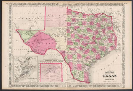
Sold2023Excellent example of Johnson’s Texas, 1866Authentic and impressive vintage map of Texas. One of the more collectible maps to be produced in the mid-19th century. A highly desirable map that details the state in full. Shows the elevated TableSee Sold Price
Sold20171852 S.A. MITCHELL MAP OF THE STATE OF TEXASFramed "Map of the State of Texas, Engraved to Illustrate Mitchell's School and Family Geography", 1852 by S.A. Mitchell (Samuel Augustus Mitchell, Philadelphia, 1790-1868), engraved by J.H. Young, haSee Sold Price
Sold20191852 map of Monterey Harbor, U. S. Coast SurveyDetailed hand-colored map of the Monterey coast in 1852. Very clean and bright with extremely light toning at vertical fold. Excellent example. Very short separation at top and bottom centerfold. FoldSee Sold Price
Sold2022Colton’s Illinois, Iowa & Missouri 1860s school mapExcellent example of an 1860s school atlas map of these Midwestern states. Clean and sound with good ink impression. Shows railroads, roads, towns, cities, rivers, etc. Insets of Vicinity of St. LouisSee Sold Price
Sold20201852 HAND TINTED OLD ANTIQUE MAP of TEXAS, MITCHELL s1852 HAND TINTED OLD ANTIQUE MAP of TEXAS, MITCHELL s SCHOOL & FAMILY GEOGRAPHY 1852 Antique Map by S. Augustus Mitchell of Pennsylvania. ??No. 13 - MAP OF THE STATE OF TEXAS. Engraved to Illustrate MSee Sold Price
Sold2019Samuel Augustus Mitchell (1790-1868), "Map of the StateSamuel Augustus Mitchell (1790-1868), "Map of the State of Texas," 1852, No. 13, hand colored, H. -9 in., W. - 15 3/8 in.See Sold Price
Sold2017Johnson & Ward: Antique Map of Texas, 1865JohnsonÂ’s New Map of the State of Texas, Johnson & Ward, 1865. This is an exceptionally clean example of Johnson and Ward's highly desirable 1865 map of Texas. Because of the high acidity in the pSee Sold Price
Sold2020County Map of the State of Texas, 1886Excellent and detailed map of Texas colored by county and showing most of Indian Territory and New Mexico. In this map the Texas counties are still incomplete in the West. Features a large inset planSee Sold Price
Sold2017Mitchell: Antique County Map of Texas, 1873Excellent 1873 County Map of Texas by S. Augustus Mitchell. Impressive two-page County Map of the State of Texas. Map image much larger than earlier Mitchell maps. Designed and engraved by W. H. GamblSee Sold Price
Sold20211852 Cowperthwait, Desilver, Butler map of TexasThe horizontal layout not commonly seen. “No. 13 Map of the State of Texas Engraved to Illustrate Mitchell’s School and Family Geography.” Nicely detailed with original hand-coloringSee Sold Price
Sold2022Great Colton map of MissouriExcellent 1855 first edition example of Colton's map of Missouri. Covers the entire state as well as adjacent parts of Illinois and Kansas. In Kansas, various Indian tribes are noted including the CheSee Sold Price
Sold2022Great Colton map of IowaAn excellent 1855 first edition example of Colton's map of Iowa. Like most of Colton's state maps, this map was derived from an earlier wall map of North America produced by Colton and D. Griffing JohSee Sold Price
Sold20211863 Map of Mexico including TexasBeautiful example of Johnson’s 1863 map of Mexico which includes nearly the full state of Texas. Bright and clean with decent margins. Vivid original hand coloring. New Mexico and Arizona are in earSee Sold Price
Sold20181852 Mitchell Map of Texas -- No.13 Map of the State ofTitle/Content of Map: 1852 Mitchell Map of Texas -- No.13 Map of the State of Texas Date: 1852, Philadelphia Cartographer: S Mitchell Size: 8 X 10.5 in. This is a very nice map of Texas from its earlySee Sold Price
Sold2017Mitchell: Antique Map of Texas, 1852Map: 1852 Mitchell Map of Texas -- Map of the State of Texas Date Printed: 1852, Philadelphia Cartographer: S Mitchell Size: 8 x 10.5 in. Condition: Very good. Toning and finger soiling, mostly in theSee Sold Price
Sold20201846 Mitchell Map of Texas -- No. 13 Map of the StateTitle/Content of Map: 1846 Mitchell Map of Texas -- No. 13 Map of the State of Texas Cartographer: S Mitchell Year/Place: 1846, Philadelphia Size: 10.3 X 8 in. This is an excellent map of Texas featurSee Sold Price
Sold20201858 Mitchell Map of Texas -- No. 13 Map of the StateTitle/Content of Map: 1858 Mitchell Map of Texas -- No. 13 Map of the State of Texas Cartographer: S Mitchell Year/Place: 1858, Philadelphia Size: 8.1 X 10.6 in. This is an excellent map of Texas, filSee Sold Price
Sold20221833 Finley map of North America – excellent exampleA fascinating antique map of North America, showing immense Russian Possessions (Alaska) down to the United States. Buenaventura River extends from the Rockies to San Francisco Bay. The Rocky MountainSee Sold Price
Sold2019Civil War Military Map of the U.S. - 1862Excellent example of the more desirable of the two extant variants of this map. This variant, showing a layout of the states rather than military zones, offers a wonderful insight into the political sSee Sold Price
Sold20231st edition map of the South Pole, or Antarctica by ColtonExcellent 1855 first edition example of J. H. Colton’s map of the South Pole, Antarctica or Southern Polar Regions. The map gives an excellent overview of the state of Antarctic exploration andSee Sold Price
Sold20181852 Mitchell Antique Map of TexasTitle/Content of Map: 1852 Mitchell Map of Texas -- No. 13 Map of the State of Texas Date Printed: 1852 Philadelphia Cartographer: S Mitchell / Cowperthwait & Co. Size: 8 x 10.4 in. A nice pre-Civil WSee Sold Price
Sold2023VINTAGE STATE MAPS / TRAVEL EPHEMERA, UNCOUNTED LOTVINTAGE STATE MAPS / TRAVEL EPHEMERA, UNCOUNTED LOT,for states Texas, Tennessee including Memphis, and South Dakota, with Phillip's 66 and Standard examples.20th century. Provenance: From the Dean andSee Sold Price
Sold20207 Maps incl North America and PanamaIncludes Panama to Guayaquil (Thomas Kitchin), Mexico & Gautemala (Thomas Coperthwait & Co., 1850), Utah & Nevada (Mitchell), California (Mitchell, 1874), State of Texas (Mitchell, 1852), North AmericSee Sold Price
1083 Lots AwayMynt AuctionsStately by State House Sterling Silver Steak Knife Set 4pc Texas Sized CustomUS$10
23 hrs LeftPotter & Potter AuctionsSTORM, Mark. Official Texas Brags Map of North America. 194...US$200(1 bid)
Jun 01Richmond Auctions1933 Texaco Agent The Texas Company SSP Truck Keyhole Sign "Black T"US$25(1 bid)
6 days LeftJasper521898 Rand McNally Map of Texas [verso] Indian Territory and Oklahoma -- Texas [verso] Oklahoma andUS$70
Jun 29JM Hobby Supply and Railroad Artifact AuctionsMissouri-Kansas-Texas RR Handlan Switch LampUS$100
Jun 12Dan Morphy AuctionsLOT OF 2 MAPS: LANDS IN THE COUNTIES OF RUNNELS & TOM GREEN RUNNELS COUNTY TEXAS MAPS.US$200
8 hrs LeftJasper52BALKAN PENINSULA Greece Austria Rumili Servia Turkey Romania STANFORD 1904 mapUS$40
8 hrs LeftJasper52BALKAN PENINSULA Greece Austria Rumili Servia Turkey Romania STANFORD 1894 mapUS$45
8 hrs LeftJasper52BALKAN PENINSULA Greece Austria Rumili Servia Turkey Romania STANFORD 1896 mapUS$45
6 days LeftJasper521866 Johnson Map of Wisconsin and Michigan -- Johnson's Michigan and WisconsinUS$55


![1898 Rand McNally Map of Texas [verso] Indian Territory and Oklahoma -- Texas [verso] Oklahoma and (1 of 2)](https://p1.liveauctioneers.com/5584/329422/177662173_1_x.jpg?height=282&quality=70&version=1715717898)


