Sold20191792 Elwe Map of Italy -- LTitle: 1792 Elwe Map of Italy -- L'Italie Dressee sur les Observations de Mrs. de l'Academie Royale des SciencesÂ… Date: 1792, Amsterdam Medium: J Elwe Size: 18.2 X 21.6 in. Additional Information:See Sold Price
Sold2023FRAMED CIRCA 1750 HANDCOLORED MAP OF ITALY: L'ITALIE, VAUGONDY DIDIER ROBERT, Circa 1750. - FramedFRAMED CIRCA 1750 HANDCOLORED MAP OF ITALY: L'ITALIE, VAUGONDY DIDIER ROBERT, Circa 1750. Handcolored, of the period, Vaugondy Didier Robert map of Italy. Framed in wooden moulding with green mat. SigSee Sold Price
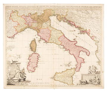
Sold2022Nicolas Sansom, map of Italy, 1701Nicolas Sansom, map of Italy, 1701, "L'Italie Divisee Suivant l'Estendue de Toutes ses Sourverainetes…", Pieter Schenk, Amsterdam, 1701, hand-colored copper plate engraving on laid paper, 20.25"See Sold Price
Sold2021Nicolas Sansom, map of Italy, 1701Nicolas Sansom, map of Italy, 1701, "L'Italie Divisee Suivant l'Estendue de Toutes ses Sourverainetes…", Pieter Schenk, Amsterdam, 1701, hand-colored copper plate engraving on laid paper, 20.25"See Sold Price
Sold2018Bonne: Antique Map of Italy, 1780TITLE/CONTENT OF MAP: 'L'Italie' A map of Italy DATE PRINTED: 1780 IMAGE SIZE: Approx 34.0 x 23.0cm, 13.25 x 9 inches (Large); Please note that this is a folding map. TYPE: Antique copperplate engraveSee Sold Price
Sold2018Brue: Antique Map of Northern Italy & the Alps, 1875TITLE/CONTENT OF MAP: 'Carte Physique et Politique de l'Italie de la Region des Alpes et des Provinces Autrichiennes sur l'Adriatique' A physical and political map of Northern Italy and the Alps incluSee Sold Price
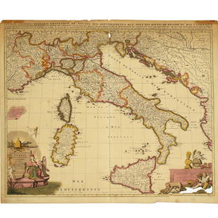
Sold2016C. 1695 Giacomo Cantelli map of Italy by BARBEY[Italy] Giocomo Cantelli engraved map of Italy, c. 1695: "L'Italia con Le sue Poste e Strade Principali descritta da Giacomo Cantelli da Vignola." Engraved by Antonio Barbey, map shows the Adriatic, sSee Sold Price
Sold2023Baedeker, Karl 1901 Lot of 38 Antique Maps. ItalyLithograph Maps Published 1901, Leipzig for "L'Italie des Alpes a Naples" by Karl Baedeker. Folds as issued. Paper Size: Up to 13 x 12 inch (33 x 31cm) Good ConditionSee Sold Price
Sold2021De L'Isle Philippe Buache engraved map of Antique ItalyDe L'Isle Philippe Buache Double hemisphere map of Antique Italy 1800 Important map of Guillaume de L'Isle corrected by Philippe Buache and edited by Dezauche in 1800 ,This one is not revised by DezauSee Sold Price
Sold20201720 Chatelain Map of Italy -- Nouvelle Carte De L'EtatTitle: 1720 Chatelain Map of Italy -- Nouvelle Carte De L'Etat Present De L'Italie Pur Parvenir par Une Methode Nouvelle A La Connoissance De La Geographie Et De L'Histoire. . . Cartographer: H ChatelSee Sold Price
Sold2019Historical Map of ScotlandTitle: Historical Map of Scotland Publication Date: 1952 Cartographer: BULLOCK, L. G. Publisher: JOHN BARTHOLOMEW & SON Size: 36.5 X 24.25 Vividly colored maps showing historic sites surrounded by armSee Sold Price
Sold2019Sanson map of Italy 1701Heading: Author: Sanson, Nicolas Title: L'Italie Divisee Suivant l'Estendue de Toutes ses Sourverainetes... Place Published: Amsterdam Publisher:Pieter Schenk Date Published: 1701 DescSee Sold Price
Sold2022LARGE HAND-COLORED MAP OF ASIA 20” x 24” sight. Framed 29.5” x 33.5”.LARGE HAND-COLORED MAP OF ASIA“Asia, Concinnata Secundum Observationes Academia Regalis Scientiarum et nonnullas alias, et juxta annotations recentissimas per G. de L'Isle”, Tobias ConradSee Sold Price
Sold2024Janvier Map of Italy - Italian Peninsula - Corsica, Sardinia"L'Italie divisee en ses differents etats Royaumes et Republiques" A beautiful example of Le Sieur Janvier's decorative map of Italy. Janvier's map covers from the Gulf of eyon eastward to include allSee Sold Price
Sold2023De L'Isle Philippe Buache engraved map of Italy 1802Important map of Guillaume de L'Isle corrected by Philippe Buache and edited by Dezauche in 1800 ,the Venetian Republic is still intact , The city state suffered defeats from the navy of the Ottoman ESee Sold Price
Sold2017Map of Italy Posts & Roads,1695 by Giacomo da CantelliItaly with its Posts and Highways described by Giacomo da Vignola Cantelli Geographer Serenis the Lord Duke of Modena, c.1695. L'Italia con le sue Poste e Strade Principali descritta da Giacomo CantelSee Sold Price
Sold2017Millar: Map of Italy, 1768Map: 1768 Millar Map of Italy -- A New and Correct Map of Italy from the Latest Improvements and Regulated by Astronomical Observations Cartographer: G Millar Year/Place: 1768 (penciled) Dimensions: 1See Sold Price
Sold2024Tardie Map of Italy, 1874Tardie Map of Italy Provenance: 'Atlas Universel de Geographie ancienne et moderne', by A. Tardieu and A. Vuillemin for 'L'Intelligence de la Geographie Universelle de Malte-Brun LaVallee, Paris, 1874See Sold Price
Sold2024Bonne & Desmarest - 4 Maps of Italy or surrounding IslandsThis fine map engraving is from Rigobert Bonne and Nicolas Desmarest's Atlas encyclop?dique, contenant la g?ographie ancienne, et quelques cartes sur la g?ographie du moyen age, la g?ographie moderneSee Sold Price
Sold20191838 Map of Italy and SicilyCarte de L'Italie Ancienne and de L'Illyrie et de La Sicilie par Delamanche 1838See Sold Price
Sold2019Fenning & Collyer 1765 Map of ItalyCopper Engraved Map Published 1764-65, London for "A New System of Geography: or, A General Description of the World" by Daniel Fenning & Joseph Collyer. Maps by G. Rollos, J. Gibson and others, mostlSee Sold Price
Sold2019Fenning & Collyer 1765 Map of ItalyCopper Engraved Map Published 1764-65, London for "A New System of Geography: or, A General Description of the World" by Daniel Fenning & Joseph Collyer. Maps by G. Rollos, J. Gibson and others, mostlSee Sold Price
May 09Hunt and Peck Estate Services, Inc.G. De L'Isle/Covens & Mortier Map Of Congo And The Country Of The CafresUS$140
Featured2 days LeftJasper521792 Elwe Map of Southern Russia in Europe -- Partie Meridionale de Moscovie Dresse par G. De L'IsleUS$190
May 09Hunt and Peck Estate Services, Inc.G. De L'Isle/Covens & Mortier Map Of Egypt, Nubia, And AbissiniaUS$140
May 09Hunt and Peck Estate Services, Inc.G. De L'Isle/Covens & Mortier Africa Geographic Table MapUS$140
2 days LeftJasper521719 Chatelain Map of the Adriatic and Venice Republic -- Carte de Geographie des Differents EtatsUS$190
May 17Ni-Cola Classics - Automobilia Auction & Classic Car SalesBuch 33-parts Italian books from the 50s-2010s€50
3 days LeftDoyle New YorkHenderson and Hume's Lahore to Yarkand, with bird plates by KeuelemansUS$300


![C. 1695 Giacomo Cantelli map of Italy by BARBEY: [Italy] Giocomo Cantelli engraved map of Italy, c. 1695: "L'Italia con Le sue Poste e Strade Principali descritta da Giacomo Cantelli da Vignola." Engraved by Antonio Barbey, map shows the Adriatic, s](https://p1.liveauctioneers.com/179/85723/44107979_1_x.jpg?height=310&quality=70&version=1457208230)