Sold2024West Indies Caribbean Florida Bahamas Cuba ADMIRALTY chart 1876 (1949) old mapTITLE/CONTENT OF MAP: 'West Indian Islands and Caribbean Sea - Sheet I - Comprising Florida Strait, Bahama Islands and the Greater Antilles' DATE PRINTED: Surveyed to 1948. Published 1876. New editionSee Sold Price
Sold2023De Eylanden van Pehou' by VAN KEULEN. Penghu Islands Taiwan. VOC chart 1753 mapTitle: De Eylanden van Pehou' by VAN KEULEN. Penghu Islands Taiwan. VOC chart 1753 map Description: De Eylanden van Pehou' by Johannes van Keulen (1753). Early 18th century Dutch sea chart with old coSee Sold Price
Sold2017De Wit Portolan Sea Chart of EuropeTotius Europae Victoria... Frederic De Wit (1630-1706). Engraved map with original hand color. Amsterdam, 1675. 20 x 35 1/2 inches sheet, 27 1/2 x 43 inches framed. “The most striking and decorativeSee Sold Price
Sold2019Bahamian Governor William Shirley Writes of EspionageShirley William Manuscript Document Signed "W Shirley" as Governor of the Bahamas, 2 pages, 9" x 14.25", front and verso. New Providence, Bahama Islands, August 27, 1762. Also signed by the author ofSee Sold Price
Sold2016Vestie Davis. Yard Long View of Coney Island.Vestie Davis. Yard Long View of Coney Island. 1968. Signed and dated. Oil on canvas. Excellent condtion. Great example of Davis’ work with many figures and lots of action. 36”w x 12”h with frameSee Sold Price
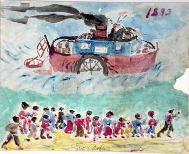
Sold2021Sam Doyle. Red Cross Boat To Sea Island.Sam Doyle. The Red Cross Boat Responding To the Sea Island Hurricane of 1893. Signed. Watercolor and graphite on found paper. Minor foxing and loss at middle right, otherwise great environmental condiSee Sold Price
Sold202370304: A Marshall Islands Navigation Map Micronesia, 1A Marshall Islands Navigation Map Micronesia, 19th century Constructed of coconut palm leaf midribs and shells. Such maps or charts were for navigating specific atolls and islands in MicrSee Sold Price
Sold2023DALE CHIHULY ( AMERICAN, B. 1941).Large Glass Sea Form Vase. Signed on the base. From a Great Neck, Long Island, NY estate. - Dimensions: 9 h x 8.5" w x 9" d.See Sold Price
Sold2015Joseph Yoakum, (American, 1886-1972), Mt Yeboa inJoseph Yoakum, (American, 1886-1972), Mt Yeboa in Julian Alps in Yugoslava on Medeterranian Sea, 1968, watercolor and pencil on paper, signed, titled and dated upper left, 14" x 22"See Sold Price
Sold2015Leonard Foujita (1886 - 1968) Collage Signed.Watercolor and gouache , pencil and collage / Paper on board. 28" x 31". Very interesting piece. A similar piece was auctioned at Christies 2/7/2014 in London. This piece emcompasses many similar partSee Sold Price
Sold2020Leonard Tsuguharu Foujita (1886 - 1968)Leonard Tsuguharu Foujita (1886 - 1968) French-Japanese painter. Ink on Paper. Measure 10"in H x 22"in W and 15 1/2"in H x 27 1/2"in W with frame. Immediately after graduating secondary school, FoujitSee Sold Price
Sold2024The Virgin Islands Map from English Danish SurveysAntique reproduction full color example on paper of the map of The Virgin Islands from The West India Atlas by Thomas Jeffreys, the geographer to the King. Shows anchorages, soundings, shoals and chanSee Sold Price
Sold2020Japanese Mixed Media on Paper, Two CatsProbably Leonard Tsuguharu Foujita, (Japanese, 1886-1968) Signed Foujita 13"h x 17-1/2"wSee Sold Price
Sold2022FOUJITA, TSUGUHARU. 1886-1968. A Book of Cats. New York: Covici Friede, 1930.FOUJITA, TSUGUHARU. 1886-1968. A Book of Cats. New York: Covici Friede, 1930. 4to (330 x 250 mm). 20 plates printed on hand-made Arches paper, stamped 'Made in France'; additional suite of 20 etchedSee Sold Price
Sold2023Léonard Tsuguharu Foujita (French/Japanese, 1886-1968) Collotypes on Handmade Arches Paper, 193Léonard Tsuguharu Foujita (French/Japanese, 1886-1968) Collotypes on Handmade Arches Paper, 1930, "Book of Cats", H 7.75" W 10.1" | Eighteen (of Twenty Works). Each work is signed and dated in thSee Sold Price
Sold2023Catesby, Folio - Laurel-Tree of Carolina (Magnolia). 2-61We are pleased to offer this remarkable, originally hand-colored engraving from Mark Catesby’s The Natural History of Carolina, Florida and the Bahama Islands: Containing the Figures of Birds,See Sold Price
Sold2022LARGE ARCHITECTS PRINT / MAP / CHART CABINETFantastic very large Architectural draftsman/chart/map/print flat file - George III-Style mahogany with satinwood inlay, inset tooled leather top. 8 Drawer over 4 drawer. from the Audubon Gallery, KinSee Sold Price
Sold2022Mark Catesby Engraving(British, 1679-1749) T. 67 Rudiscilla Americana, from The Natural History of Carolina, Florida and The Bahama Islands, 1731-1743 edition hand colored engraving on laid paper, sheet 20-5/8 x 14-1/4 in.See Sold Price
Sold2024Catesby, Folio - Horned Caterpillar with Pigeon Plum. 2-94We are pleased to offer this stunning originally hand-colored engraving from Mark Catesby?s The Natural History of Carolina, Florida and the Bahama Islands: Containing the Figures of Birds, Beasts, FiSee Sold Price
Sold2020A COLLECTION OF MORE THAN 600 RAILROAD PASSESAn archive of 615 passes dated from 1904 to 1921 for Mr. Graham G. Lacy, President of St. Joseph and Grand Island Railway. Railroads represented include The Pullman Company, Burlington Route, Kansas CSee Sold Price
Sold2023PHILCO TONE POWER FOREIGN RECEPTION MAPGreat canvas advertising map for Philco Radios. It showed the Countries that got reception from its radios. Great colors. Map partial loose at bottom. 58"x40" Very Good-ExcellentSee Sold Price
Sold2021Claude Conover (OH, 1907-1994) TUCUB, Ceramic StoolProperty from a Private Collection, Sea Island, GA Description: Claude Conover (Ohio, 1907 - 1994) TUCUB, Ceramic Stool, of circular form, signed 'Claude Conover' and titled 'TUCUB' on base, overaSee Sold Price
Sold2022Two 18K Gold Necklaces and One 14K Gold NecklaceProperty from a Private Collection, Sea Island, GA Description: Two 18K Gold Necklaces and One 14K Gold Necklace, comprising a 17 in. 18K gold wide chain necklace marked 'Italy, 18Kt' on clasp, aSee Sold Price
2021GREAT NORTHERN’S 2 GREAT TRAINS SYSTEM MAP.Huge dramatic reverse glass advertising Great Northern's two great trains, Empire Builder and Western Star. In script just below Great Northern logo it states "Steamliners twice a day, each way, betweSee Sold Price
Featured4 days LeftJasper52Marshall Islands North Pacific Ocean Micronesia ADMIRALTY chart 1891 (1953) mapUS$120
4 mins LeftTrillium Antique Prints & Rare BooksCatesby, Folio - Pied-Billed Dobchick. 1-91US$200(1 bid)
4 mins LeftTrillium Antique Prints & Rare BooksCatesby, Folio - Green Spotted Snake with Wild Unction. 2-53US$200
4 mins LeftTrillium Antique Prints & Rare BooksCatesby, Folio - Mancaneel Tree with two Butterflies. 2-95US$200
4 mins LeftTrillium Antique Prints & Rare BooksCatesby, Folio - Tiger Swallow-Tail with Wafer Ash. 2-83US$200
Jun 27Rail & Road AuctionsGroup of Ninety Post Cereal Railroad Tins - Rock Island, Reading, Great Northern, Wabash, MilwaukeeUS$30
3 days LeftLoon EstatesLeonard Tsuguharu Foujita, Little Girl with Rag Doll Ukiyo-e Woodblock PrintUS$120(2 bids)
4 mins LeftTrillium Antique Prints & Rare BooksDe Jode, Rare, pub. 1593 - Map of Islands including Sicily, Corsica, Sardinia, Cyprus, Candia,US$210(3 bids)
Jun 27Capsule AuctionsHiroshi Yoshida - Three Little Islands (from series The Inland Sea, second series)US$100
4 mins LeftTrillium Antique Prints & Rare BooksDe Jode, Rare, pub. 1593 - Maps of the Baltic, North Sea & Russia (Livoniae Provinciae Ac Eivs /US$100
Jun 23Schilb Antiquarian Rare Books1870 BEAUTIFUL Life of Jesus Christ Fleetwood Bible ART Miracles Jerusalem MapUS$92(5 bids)
Jun 23Schilb Antiquarian Rare Books1790 Life of Jesus Christ Fleetwood Bible ART Miracles Jerusalem MAP Holy LandUS$105(5 bids)
4 mins LeftTrillium Antique Prints & Rare BooksChatelain - 3 Engravings related to Madagascar and West Indies / Antilles IslandsUS$75(1 bid)


![[BAEDEKER] GUIDE BOOKS. LOT OF 8+1 SOLD TOGETHER (1 of 2)](https://p1.liveauctioneers.com/8124/333020/179782282_1_x.jpg?height=282&quality=70&version=1718115761)


![[Duckworth (John Thomas)] (1 of 2)](https://p1.liveauctioneers.com/1569/331836/179014938_1_x.jpg?height=282&quality=70&version=1717415535)


